
Smarts Mountain Loop Hike
A Loop Hike Over the Lambert Ridge to the Summit of Smarts Mountain.
Smarts Mountain Loop Hike
A Loop Hike Over the Lambert Ridge to the Summit of Smarts Mountain.
Details
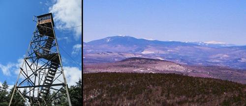
Join me for a modest 7.6 mile loop hike to the summit of Smarts Mountain in the Upper Valley. Although its elevation is a mere 3240 feet, it has a feel similar to higher peaks in the White Mountains. It offers a boreal forest, open quartzite ledges and an old fire tower on its summit. The firetower was abandoned in 1976, but is still accessible. Other points of interest include the Ranger Cabin (now used as a backpacking shelter) and the ruins of an old garage where rangers parked near the end of a jeep trail. There are ample views across the surrounding countryside and mountains...as well as over the Reservoir and Cummins Ponds. We will be taking the steeper Lambert Ridge Trail for the ascent and returning via the Ranger Trail...the current and former portions of the Appalachian Trails, respectively.
Total Distance and Elevation Gain: Approximately 7.6 miles with 2130 ft elevation gain. The portion of the trail just prior to the summit is modestly steep.
Total Time: 6.5 hours depending on breaks and group's speed.
Rain or harsh weather may postpone to another date or cancel, as appropriate.
What to Bring: Typical early spring hiking gear should be appropriate: convertible hiking pants, good sturdy hiking boots with thick socks, a windbreaker/raingear and extra layers (e.g. fleece). Also bring along lunch, snacks and plenty of water (at least 2-L). Optionally, pack sunscreen, bug spray, and anything else that you may require for a day hike. NOTE: Significant snow and ice and, therefore, traction should not be an issue with the week's warm up.
Carpooling: Contact other participants or the trip leader to arrange for a rideshare to the trailhead.
Afterwards: If there is sufficient interest, we will have drinks and/or dinner in the area afterwards.
Directions
From Vermont: Take Exit 14 off of I-91 and follow VT-113 E and East Thetford Road to Dorchester Road in Lyme. This is approximately 8 miles (20 minutes).
From Concord, NH and points east and south: From Rte. 93, turn onto Route 89 and continue to Exit 18 (Route 120 North). Continue for 4.9 miles, turning right onto Lyme Road. At the traffic circle, continue straight onto Rt. 10 (Lyme Road). Follow Rt 10 and turn right onto the common and then right onto Dorchester Road. This is approximately 78.6 miles (89 minutes).
NOTE: Follow the signs for the Dartmouth Skiway from the common to Dorchester Road. The parking lot is on the left just before the iron bridge over Grant Brook. The AT crosses the road here.
Look for a gray Hyundai Elantra.
For GPS Users: 43.797073, -72.071751 (346-390 Dorchester Rd; Lyme, NH 03768)
About this event
Join me for a modest 7.6 mile loop hike to the summit of Smarts Mountain in the Upper Valley. Although its elevation is a mere 3240 feet, it has a feel similar to higher peaks in the White Mountains. It offers a boreal forest, open quartzite ledges and an old fire tower on its summit. The firetower was abandoned in 1976, but is still accessible. Other points of interest include the Ranger Cabin (now used as a backpacking shelter) and the ruins of an old garage where rangers parked near the end of a jeep trail. There are ample views across the surrounding countryside and mountains...as well as over the Reservoir and Cummins Ponds. We will be taking the steeper Lambert Ridge Trail for the ascent and returning via the Ranger Trail...the current and former portions of the Appalachian Trails, respectively.
Total Distance and Elevation Gain: Approximately 7.6 miles with 2130 ft elevation gain. The portion of the trail just prior to the summit is modestly steep.
Total Time: 6.5 hours depending on breaks and group's speed.
Rain or harsh weather may postpone to another date or cancel, as appropriate.
What to Bring: Typical early spring hiking gear should be appropriate: convertible hiking pants, good sturdy hiking boots with thick socks, a windbreaker/raingear and extra layers (e.g. fleece). Also bring along lunch, snacks and plenty of water (at least 2-L). Optionally, pack sunscreen, bug spray, and anything else that you may require for a day hike. NOTE: Significant snow and ice and, therefore, traction should not be an issue with the week's warm up.
Carpooling: Contact other participants or the trip leader to arrange for a rideshare to the trailhead.
Afterwards: If there is sufficient interest, we will have drinks and/or dinner in the area afterwards.
Directions to the trailhead
Get directionsFrom Vermont: Take Exit 14 off of I-91 and follow VT-113 E and East Thetford Road to Dorchester Road in Lyme. This is approximately 8 miles (20 minutes).
From Concord, NH and points east and south: From Rte. 93, turn onto Route 89 and continue to Exit 18 (Route 120 North). Continue for 4.9 miles, turning right onto Lyme Road. At the traffic circle, continue straight onto Rt. 10 (Lyme Road). Follow Rt 10 and turn right onto the common and then right onto Dorchester Road. This is approximately 78.6 miles (89 minutes).
NOTE: Follow the signs for the Dartmouth Skiway from the common to Dorchester Road. The parking lot is on the left just before the iron bridge over Grant Brook. The AT crosses the road here.
Look for a gray Hyundai Elantra.
For GPS Users: 43.797073, -72.071751 (346-390 Dorchester Rd; Lyme, NH 03768)
Who's going (2)


Questions about this event?
Reach out to the host, shep5, for route details, carpooling, or what to bring.
Email the hostYou can also ask in the event discussion below.
Event discussion
Log in to join the conversation.