
Mts.Gunstock, Belknap & Piper Hike
Join us for a fun, 5 mile loop in the Belknap Range!
Mts.Gunstock, Belknap & Piper Hike
Join us for a fun, 5 mile loop in the Belknap Range!
Details
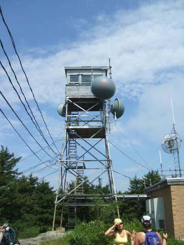
This moderate hike and invigorating climb will bring us to magnificent views of Lake Winnipesaukee. On a clear day, the Ossipee Mountain Range rises from the shores of Winnipesauke and Mount Washington can be spotted in the distance. Belknap Mountain has a firetower that is sometimes manned on weekends.
It's a 5 mile loop with 1,400 feet of elevation gain. It's a good loop because once we summit Gunstock, we stay pretty high. A lot of bang for our buck!
We'll start at the bottom of the Carriage Road and take the Gunstock Mountain Trail to its summit [2,240']. We'll then hook up with a variety of trails to reach the Belknap Mountain firetower [2,382'] where we'll have lunch. We'll again use a variety of trails to reach Piper Mountain [2,044'] and check out its stone chairs. We'll then head back using the Piper Mountain Trail down to the bottom of the Carriage Road where we began.
Dress properly for the hike. Cotton shirts, walking pants or shorts, and hiking shoes with appropriate socks are recommended. Wear a daypack to place your lunch, water, extra shirt/sweater, and rain jacket into. You'll get bonus points for bringing matches with firestarter, first aid kit, flashlight, compass, map and/or guidebook,and pocketknife.
It should take 4-5 hours to complete this hike. We start as a group and finish as a group. We wait at all trail junctions and summits. This trip isn't for you if you are faster than the group and don't want to hike with us, if you want to head off on your own, or if you are slower than the group and expect us to constantly wait for you.
After the hike, we'll find an ice cream stand to enjoy our first ice cream cone of the season!
Directions
From the West
- From I-93 take Exit 20 and from the exit ramp turn easterly onto Rt. 3 North
- Follow Rt. 3 for approximately 9.7 miles and at the intersection wih Rt. 11A, turn right onto Rt. 11A
- Follow Rt. 11A for 2.2 miles, then, in Gilford village, turn right onto Belknap Mountain Road. Follow Belknap Mountain Road, bearing left after 0.8 mile,and right at 1.4 mile. After another 1.0 mile you will reach a fork.
- Bear left at the fork onto Belknap Carriage Road and follow the road for 1.5 miles. Park in the lot at the end of road.
- We will be driving a blue Toyota FJ Cruiser.
From the Southeast
- From Rt. 16 in Rochester, follow Rt. 11 north to the junction with Rt. 11A in West Alton. Then turn onto Rt. 11A and follow the road for approximately 7.7 miles. In Gilford village, turn onto Belknap Mountain Road.
- Pick up the remaining directions from above.
About this event
This moderate hike and invigorating climb will bring us to magnificent views of Lake Winnipesaukee. On a clear day, the Ossipee Mountain Range rises from the shores of Winnipesauke and Mount Washington can be spotted in the distance. Belknap Mountain has a firetower that is sometimes manned on weekends.
It's a 5 mile loop with 1,400 feet of elevation gain. It's a good loop because once we summit Gunstock, we stay pretty high. A lot of bang for our buck!
We'll start at the bottom of the Carriage Road and take the Gunstock Mountain Trail to its summit [2,240']. We'll then hook up with a variety of trails to reach the Belknap Mountain firetower [2,382'] where we'll have lunch. We'll again use a variety of trails to reach Piper Mountain [2,044'] and check out its stone chairs. We'll then head back using the Piper Mountain Trail down to the bottom of the Carriage Road where we began.
Dress properly for the hike. Cotton shirts, walking pants or shorts, and hiking shoes with appropriate socks are recommended. Wear a daypack to place your lunch, water, extra shirt/sweater, and rain jacket into. You'll get bonus points for bringing matches with firestarter, first aid kit, flashlight, compass, map and/or guidebook,and pocketknife.
It should take 4-5 hours to complete this hike. We start as a group and finish as a group. We wait at all trail junctions and summits. This trip isn't for you if you are faster than the group and don't want to hike with us, if you want to head off on your own, or if you are slower than the group and expect us to constantly wait for you.
After the hike, we'll find an ice cream stand to enjoy our first ice cream cone of the season!
Directions to the trailhead
Get directionsFrom the West
- From I-93 take Exit 20 and from the exit ramp turn easterly onto Rt. 3 North
- Follow Rt. 3 for approximately 9.7 miles and at the intersection wih Rt. 11A, turn right onto Rt. 11A
- Follow Rt. 11A for 2.2 miles, then, in Gilford village, turn right onto Belknap Mountain Road. Follow Belknap Mountain Road, bearing left after 0.8 mile,and right at 1.4 mile. After another 1.0 mile you will reach a fork.
- Bear left at the fork onto Belknap Carriage Road and follow the road for 1.5 miles. Park in the lot at the end of road.
- We will be driving a blue Toyota FJ Cruiser.
From the Southeast
- From Rt. 16 in Rochester, follow Rt. 11 north to the junction with Rt. 11A in West Alton. Then turn onto Rt. 11A and follow the road for approximately 7.7 miles. In Gilford village, turn onto Belknap Mountain Road.
- Pick up the remaining directions from above.
Who's going (5)



Questions about this event?
Reach out to the host, Gandalf, for route details, carpooling, or what to bring.
Email the hostYou can also ask in the event discussion below.
Event discussion
No comments yet.
Log in to join the conversation.