
Stunt High Trail to Saddle Peak
Panoramic Views and Dramatic Sandstone Formations
Stunt High Trail to Saddle Peak
Panoramic Views and Dramatic Sandstone Formations
Details
Date: March 29, 2014
Time: 9:30 a.m.
Near: Calabasas, CA 91302
Distance: 8 miles round trip
Elevation gain: 1677’
Hike time: 4 1/2 hours
Difficulty: Moderate
Hike Type: Out and Back
Summary: Stunt High Trail begins with a pleasant shaded walk along Cold Creek Canyon and is one of the secret treasures of the Santa Monica Mountains. A year-round stream and a protected north-facing canyon provide a rich variety of ferns and flowering plants in the 600-acre preserve.
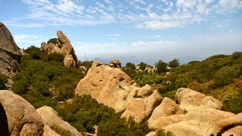
This hike has a terrific payoff at the end of a long steady climb in the way of panoramic views and dramatic sandstone formations at the top of Saddle Peak. Saddle Peak is the sixth tallest summit in the Santa Monica Mountain range at 2805 feet. We will follow along the creek and make a left at the trail junction and pass an oak grove. We continue our steady ascent on Stunt High Trail until we access a trail that meets up with the Backbone Trail. Along the way we will hike through chaparral and Manzanita. Turn left onto the Backbone Trail going to Saddle Peak. This hike provides a steady aerobic workout.
Directions
Trailhead:
From 101 North, exit Topanga Canyon Blvd South (CA-27), go 1.6 miles, turn right at Mulholland DR for .5 miles, turn left at Mulholland HWY and go 5.3 miles, turn left at Stunt RD for 1.0 mile to the pullout on the right.
From 101 South, exit on Las Virgenes Road and head south for 3 miles to Mulholland Highway. Turn left and continue 4 miles to Stunt Road. Turn right and drive 1 mile to the pullout on the right.
From Santa Monica, drive north on PCH/Highway 1 to Topanga Canyon Blvd (CA-27) and go 4.3 miles. Turn left at Old Topanga Canyon RD, go 3.7 miles. Turn left to stay on Old Topanga Canyon for 1.6 miles. Turn left to stay on Old Topanga Canyon Rd for .4 miles. Turn left at Mulholland Hwy for 3.6 miles. Turn left at Stunt Rd for 1.0 mile to the pullout on the right. We will gather at the parking lot. I will be driving a gray Subaru Outback.
What to Bring: Good hiking boots/shoes. A hiking/trekking pole may be useful for the occasional step ascent/descent on the trail, but not necessary. Pack a lunch, snacks and bring plenty of water. Bring a hat/cap and sunscreen.
Carpooling: Contact other members to carpool; share the conversation and travel expenses.
After the hike, we can have lunch at Wolf Creek Restaurant & Brewing Company: 26787 Agoura Road, Calabasas, CA 91302
http://www.wolfcreekbrewingco.com/locations.html#Calabasas
Rain Cancels.
About this event
Date: March 29, 2014
Time: 9:30 a.m.
Near: Calabasas, CA 91302
Distance: 8 miles round trip
Elevation gain: 1677’
Hike time: 4 1/2 hours
Difficulty: Moderate
Hike Type: Out and Back
Summary: Stunt High Trail begins with a pleasant shaded walk along Cold Creek Canyon and is one of the secret treasures of the Santa Monica Mountains. A year-round stream and a protected north-facing canyon provide a rich variety of ferns and flowering plants in the 600-acre preserve.
This hike has a terrific payoff at the end of a long steady climb in the way of panoramic views and dramatic sandstone formations at the top of Saddle Peak. Saddle Peak is the sixth tallest summit in the Santa Monica Mountain range at 2805 feet. We will follow along the creek and make a left at the trail junction and pass an oak grove. We continue our steady ascent on Stunt High Trail until we access a trail that meets up with the Backbone Trail. Along the way we will hike through chaparral and Manzanita. Turn left onto the Backbone Trail going to Saddle Peak. This hike provides a steady aerobic workout.
Directions to the trailhead
Get directionsTrailhead:
From 101 North, exit Topanga Canyon Blvd South (CA-27), go 1.6 miles, turn right at Mulholland DR for .5 miles, turn left at Mulholland HWY and go 5.3 miles, turn left at Stunt RD for 1.0 mile to the pullout on the right.
From 101 South, exit on Las Virgenes Road and head south for 3 miles to Mulholland Highway. Turn left and continue 4 miles to Stunt Road. Turn right and drive 1 mile to the pullout on the right.
From Santa Monica, drive north on PCH/Highway 1 to Topanga Canyon Blvd (CA-27) and go 4.3 miles. Turn left at Old Topanga Canyon RD, go 3.7 miles. Turn left to stay on Old Topanga Canyon for 1.6 miles. Turn left to stay on Old Topanga Canyon Rd for .4 miles. Turn left at Mulholland Hwy for 3.6 miles. Turn left at Stunt Rd for 1.0 mile to the pullout on the right. We will gather at the parking lot. I will be driving a gray Subaru Outback.
What to Bring: Good hiking boots/shoes. A hiking/trekking pole may be useful for the occasional step ascent/descent on the trail, but not necessary. Pack a lunch, snacks and bring plenty of water. Bring a hat/cap and sunscreen.
Carpooling: Contact other members to carpool; share the conversation and travel expenses.
After the hike, we can have lunch at Wolf Creek Restaurant & Brewing Company: 26787 Agoura Road, Calabasas, CA 91302
http://www.wolfcreekbrewingco.com/locations.html#Calabasas
Rain Cancels.
Who's going (1)
Questions about this event?
Questions for the host, Menard, about route details, carpooling, or what to bring? Ask in the event discussion below.
Event discussion
No comments yet.
Log in to join the conversation.