
All events
Share
Moderate to Strenuous
Mts. Jackson and Webster Hike
Mt. Jackson at 4,052 has the best view in the Southern Presidentials; and Mt. Webster awesome view into Crawford Notch!
Mts. Jackson and Webster Hike
Mt. Jackson at 4,052 has the best view in the Southern Presidentials; and Mt. Webster awesome view into Crawford Notch!
Details
Mt. Jackson at 4,052 has the best view in the Southern Presidentials; and Mt. Webster awesome view into Crawford Notch! We will start on the Webster-Jackson Trail and take time to enjoy the views from Elephant Head and Bugle Cliff on the ascent. After 1.4 miles we'll take the left fork to first climb the summit of Mt. Jackson. We will be going clockwise, going up to Mt. Jackson[4052'] then over to Mt. Webster [3910']. Steep pitches may be icy or crusty, and the final scramble up the ledges on the cone can be tricky. The ridge walk to Mt. Webster is a winter wonderland, although this trail, may be hard to follow if there is deep, wind-drifted snow. The descent after Mt. Webster is steady back to the cars.
This is a dog friendly hike.
We will hike about 6.5 miles with a 2,400' elevation gain. It should take us 5.5 hours to complete this trip ~ this estimate is adjusted to allow for slower travel during winter because of heavier packs, includes time for changing clothing to regulate temperature and putting on/taking off snowshoes or microspikes along the way.
This trip is considered MODERATE TO STRENUOUS because of the pace, distance, and elevation gain. You should become self-reliant by becoming familiar with the route, terrain, and potential hazards since you are ultimately responsible for your own safety.
We could alter our plans because of fatigue, weather, and/or other conditions and there is no guarantee that we will complete the entire event as described here [e.g. we might not reach the summits]. While the objective of this event is to enjoy ourselves ~ your safety and the safety of the group is the most important thing. If you underestimate the demands of the trip' overestimate your experience, knowledge, skills or abilities; or come unprepared you may put yourself or others at risk ~ consider this before you decide to participate.
Hiking safely is about being prepared to respond to an emergency situation or being able to spend a night in the woods if you have to. Bring your own stuff and know how to use it. Bring snowshoes [we may not need them but have them in your car], traction, and hand warmers for your gloves. Wear winter-insulated boots on your feet, warm socks, dress in layers [no cotton], gloves [mittens are best], warm hat and headlamp/flashlight. Some guys like to have a scarf/neck gaiter to keep their neck warm, gaiters for their boots to keep snow off their boots, ski poles and small thermos for something hot to drink. Don't forget water, lunch and snacks.
After The Hike: Everyone is welcome back at our house in Waterville Valley to socialize around the fireplace and enjoy a home cooked meal with dessert! It's BYOB and it costs $5 per person.
Lodging Option: We have 8 bunks available at our house near Waterville Valley, NH for Saturday night at $20 per night. Coffee/bagels each morning and linen/blankets/towels are provided. We have limited space in the fridge to store your beverages/food so it's best to bring a small cooler. Space is limited so email us ASAP to reserve a bunk!
Directions
From the traffic lights at the intersection of U.S. Highways 3 and 302 in Twin Mountain, turn east on US 302. Drive 8.6 miles and meet us at the AMC Highland Center parking lot. We'll be driving a blue FJ Cruiser.
About this event
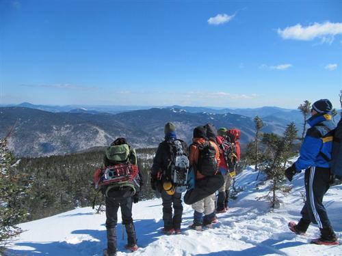
Mt. Jackson at 4,052 has the best view in the Southern Presidentials; and Mt. Webster awesome view into Crawford Notch! We will start on the Webster-Jackson Trail and take time to enjoy the views from Elephant Head and Bugle Cliff on the ascent. After 1.4 miles we'll take the left fork to first climb the summit of Mt. Jackson. We will be going clockwise, going up to Mt. Jackson[4052'] then over to Mt. Webster [3910']. Steep pitches may be icy or crusty, and the final scramble up the ledges on the cone can be tricky. The ridge walk to Mt. Webster is a winter wonderland, although this trail, may be hard to follow if there is deep, wind-drifted snow. The descent after Mt. Webster is steady back to the cars.
This is a dog friendly hike.
We will hike about 6.5 miles with a 2,400' elevation gain. It should take us 5.5 hours to complete this trip ~ this estimate is adjusted to allow for slower travel during winter because of heavier packs, includes time for changing clothing to regulate temperature and putting on/taking off snowshoes or microspikes along the way.
This trip is considered MODERATE TO STRENUOUS because of the pace, distance, and elevation gain. You should become self-reliant by becoming familiar with the route, terrain, and potential hazards since you are ultimately responsible for your own safety.
We could alter our plans because of fatigue, weather, and/or other conditions and there is no guarantee that we will complete the entire event as described here [e.g. we might not reach the summits]. While the objective of this event is to enjoy ourselves ~ your safety and the safety of the group is the most important thing. If you underestimate the demands of the trip' overestimate your experience, knowledge, skills or abilities; or come unprepared you may put yourself or others at risk ~ consider this before you decide to participate.
Hiking safely is about being prepared to respond to an emergency situation or being able to spend a night in the woods if you have to. Bring your own stuff and know how to use it. Bring snowshoes [we may not need them but have them in your car], traction, and hand warmers for your gloves. Wear winter-insulated boots on your feet, warm socks, dress in layers [no cotton], gloves [mittens are best], warm hat and headlamp/flashlight. Some guys like to have a scarf/neck gaiter to keep their neck warm, gaiters for their boots to keep snow off their boots, ski poles and small thermos for something hot to drink. Don't forget water, lunch and snacks.
After The Hike: Everyone is welcome back at our house in Waterville Valley to socialize around the fireplace and enjoy a home cooked meal with dessert! It's BYOB and it costs $5 per person.
Lodging Option: We have 8 bunks available at our house near Waterville Valley, NH for Saturday night at $20 per night. Coffee/bagels each morning and linen/blankets/towels are provided. We have limited space in the fridge to store your beverages/food so it's best to bring a small cooler. Space is limited so email us ASAP to reserve a bunk!
Directions to the trailhead
Get directions Opens turn-by-turn directions to Bretton Woods, NH, 03575 in Google Maps (new tab).
From the traffic lights at the intersection of U.S. Highways 3 and 302 in Twin Mountain, turn east on US 302. Drive 8.6 miles and meet us at the AMC Highland Center parking lot. We'll be driving a blue FJ Cruiser.
Who's going (1)
 SUSTAINING
 Questions about this event?
Reach out to the host, Gandalf, for route details, carpooling, or what to bring.
Email the hostYou can also ask in the event discussion below.
Event discussion
Log in to join the conversation.