
Osceolas Hike
An Out-And-Back Hike Over the Osceolas.
Details
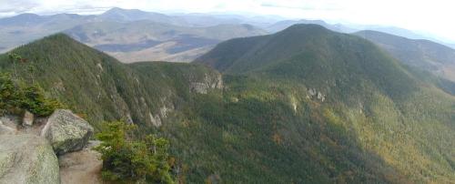
Join me for this 7.6 mile out-and-back hike up over East Osceola (4156') and onto Mt. Osceola (4340'). This trip is via the Greeley Ponds and Osceola Trails from Rt. 112 (Kancamagus Highway). The Osceolas make up the northern peaks, which encircle Waterville Valley and they provide good views over the ridge between the two and down into the valley from the open ledge on Mt. Osceola. Note: East Osceola's summit is in the trees; however, there is a ledge with views of the northern side of the ridge prior to reaching the summit. There are short portions of the trail, which will be steep and rocky.
Total Distance and Elevation Gain: 7.6 miles with approximately 3040 feet in accumulative elevation gain.
Total Time: 6-7 hours depending on breaks and group's speed.
Rain or harsh weather will postpone to another date or cancel, as appropriate.
What to Bring: Typical fall hiking gear should be appropriate: convertible hiking pants, good sturdy hiking boots with thick socks, a windbreaker/raingear and extra layers (e.g. fleece). Also bring along lunch, snacks and plenty of water (at least 2-L). Optionally, pack sunscreen and anything else that you may require for a day hike.
Carpooling: Contact other participants or the trip leader to arrange for a rideshare to the trailhead.
Afterwards: If there is sufficient interest, we will have drinks and/or dinner in the Lincoln/Woodstock area.
Directions
Due to the small parking lot at the trailhead, we will meet at Licoln Woods and commute up to the trailhead.
From the Rte. 93 Lincoln/North Woodstock exit (Exit 32 - junction with Rte. 112), take Rte 112 East (Kancamagus Hwy) for 5.1 miles. You will pass the Hancock Campground on your right and cross the East Branch Pemigewasset River just prior to reaching the parking area. The trailhead parking will be on your left (large lot...well-marked). Look for a grey Hyundai Elantra.
If coming from Conway and points east (at the junction of 16/112), Lincoln Woods will be approximately 30 miles and will be on your right...just past the Big Rock Campground.
For GPS Users: Lincoln Woods Parking Lot (44.06366,-71.588473).
About this event
Join me for this 7.6 mile out-and-back hike up over East Osceola (4156') and onto Mt. Osceola (4340'). This trip is via the Greeley Ponds and Osceola Trails from Rt. 112 (Kancamagus Highway). The Osceolas make up the northern peaks, which encircle Waterville Valley and they provide good views over the ridge between the two and down into the valley from the open ledge on Mt. Osceola. Note: East Osceola's summit is in the trees; however, there is a ledge with views of the northern side of the ridge prior to reaching the summit. There are short portions of the trail, which will be steep and rocky.
Total Distance and Elevation Gain: 7.6 miles with approximately 3040 feet in accumulative elevation gain.
Total Time: 6-7 hours depending on breaks and group's speed.
Rain or harsh weather will postpone to another date or cancel, as appropriate.
What to Bring: Typical fall hiking gear should be appropriate: convertible hiking pants, good sturdy hiking boots with thick socks, a windbreaker/raingear and extra layers (e.g. fleece). Also bring along lunch, snacks and plenty of water (at least 2-L). Optionally, pack sunscreen and anything else that you may require for a day hike.
Carpooling: Contact other participants or the trip leader to arrange for a rideshare to the trailhead.
Afterwards: If there is sufficient interest, we will have drinks and/or dinner in the Lincoln/Woodstock area.
Directions to the trailhead
Get directionsDue to the small parking lot at the trailhead, we will meet at Licoln Woods and commute up to the trailhead.
From the Rte. 93 Lincoln/North Woodstock exit (Exit 32 - junction with Rte. 112), take Rte 112 East (Kancamagus Hwy) for 5.1 miles. You will pass the Hancock Campground on your right and cross the East Branch Pemigewasset River just prior to reaching the parking area. The trailhead parking will be on your left (large lot...well-marked). Look for a grey Hyundai Elantra.
If coming from Conway and points east (at the junction of 16/112), Lincoln Woods will be approximately 30 miles and will be on your right...just past the Big Rock Campground.
For GPS Users: Lincoln Woods Parking Lot (44.06366,-71.588473).
Who's going (2)


Questions about this event?
Reach out to the host, shep5, for route details, carpooling, or what to bring.
Email the hostYou can also ask in the event discussion below.
Event discussion
Log in to join the conversation.