
Mts Eisenhower, Pierce and Jackson Hike
Columbus Day Weekend/Fall Foliage Hike over Mts. Eisenhower, Pierce and Jackson via the Edmands Path.
Mts Eisenhower, Pierce and Jackson Hike
Columbus Day Weekend/Fall Foliage Hike over Mts. Eisenhower, Pierce and Jackson via the Edmands Path.
Details
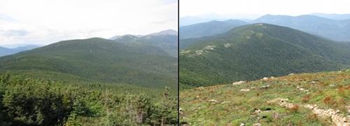
We'll ascend up to Mt. Eisenhower by way of the Edmands Path. This is mostly moderate in grade until it emerges from the woods and begins a steep rocky ascent of Eisenhower (4760'). On a clear day from the summit, there are excellent views of the Presidential Range and into the Dry River Wilderness. We'll continue onto Mt. Pierce (4312'), taking the Webster Cliff Trail. On the descent from Pierce we'll stop off at the Mizpah Spring Hut and then continue on to Mt. Jackson (4053') with its beautiful views back along the path we've traversed. We'll return via the Jackson/Webster-Jackson Trails.
Total Distance and Elevation Gain: About 10 miles with 3750 feet in accumulative elevation gain.
Total Time: Approximately 8 hours depending on breaks and lunch.
Rain or harsh weather will postpone to another date, as appropriate.
What to Bring: Typical fall hiking gear should be appropriate: convertible hiking pants or shorts (only if unusually warm...it will be chilly on the ridge/summits), good sturdy hiking boots with thick socks, extra layer(s) (as needed) and a windbreaker/raingear (just in case). Also bring along lunch, snacks and plenty of water (at least 2-L). Optionally, pack bug repellent and sunscreen and anything else that you may require for a day hike. Note: Pack your headlamp, just in case.
Afterwards: We should be completed with the hike by 5/5:30PM. If there is sufficient interest, we can grab dinner/drinks in Bretton Woods (Fabians).
Directions
We'll meet up at the hiking parking lot off Mt. Clinton Road across the road from the AMC Highland Center. This is 8.2 miles east along Route 302 from the intersection of Routes 3 and 302 in Twin Mountain. Mt. Clinton Road is here direction north of the Highland Center. Once on Mt. Clinton Road turn left into the parking lot. Look for a grey Hyundai Elantra.
After we've all gathered we will carpool further up the road to the other trailhead.
For GPS Users: Mt Clinton Road (44.223091,-71.411569).
About this event
We'll ascend up to Mt. Eisenhower by way of the Edmands Path. This is mostly moderate in grade until it emerges from the woods and begins a steep rocky ascent of Eisenhower (4760'). On a clear day from the summit, there are excellent views of the Presidential Range and into the Dry River Wilderness. We'll continue onto Mt. Pierce (4312'), taking the Webster Cliff Trail. On the descent from Pierce we'll stop off at the Mizpah Spring Hut and then continue on to Mt. Jackson (4053') with its beautiful views back along the path we've traversed. We'll return via the Jackson/Webster-Jackson Trails.
Total Distance and Elevation Gain: About 10 miles with 3750 feet in accumulative elevation gain.
Total Time: Approximately 8 hours depending on breaks and lunch.
Rain or harsh weather will postpone to another date, as appropriate.
What to Bring: Typical fall hiking gear should be appropriate: convertible hiking pants or shorts (only if unusually warm...it will be chilly on the ridge/summits), good sturdy hiking boots with thick socks, extra layer(s) (as needed) and a windbreaker/raingear (just in case). Also bring along lunch, snacks and plenty of water (at least 2-L). Optionally, pack bug repellent and sunscreen and anything else that you may require for a day hike. Note: Pack your headlamp, just in case.
Afterwards: We should be completed with the hike by 5/5:30PM. If there is sufficient interest, we can grab dinner/drinks in Bretton Woods (Fabians).
Directions to the trailhead
Get directionsWe'll meet up at the hiking parking lot off Mt. Clinton Road across the road from the AMC Highland Center. This is 8.2 miles east along Route 302 from the intersection of Routes 3 and 302 in Twin Mountain. Mt. Clinton Road is here direction north of the Highland Center. Once on Mt. Clinton Road turn left into the parking lot. Look for a grey Hyundai Elantra.
After we've all gathered we will carpool further up the road to the other trailhead.
For GPS Users: Mt Clinton Road (44.223091,-71.411569).
Who's going (2)
 GUEST MEMBER
 GUEST MEMBER
Questions about this event?
Reach out to the host, shep5, for route details, carpooling, or what to bring.
Email the hostYou can also ask in the event discussion below.
Event discussion
No comments yet.
Log in to join the conversation.