
Indian Head & Twin Mntns Loop Hike
Another Hike along the Devil's Path...this time to the Dramatic Twin and Indian Head Mountains.
Indian Head & Twin Mntns Loop Hike
Another Hike along the Devil's Path...this time to the Dramatic Twin and Indian Head Mountains.
Details
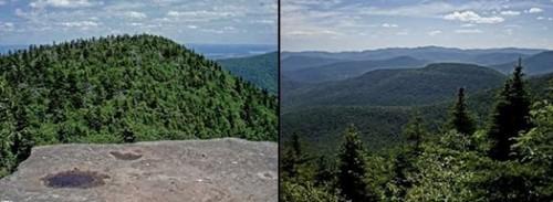
Join me for this loop hike over the Indian Head Mountain Range and its Devil's Path...Twin and Indian Head Mountains. We'll start from the Prediger Road Trailhead ascending Twin Mountain (3640') via the Jimmy Dolan Notch, where we'll utilize the famous Devil's Path for the ascent up Twin Mountain. After tagging the summit we'll return to the same notch and continue along the Devil's Path for the climb up and over Indian Head (3573') on our way over to Sherman's Lookout and the return. There are views into the Indian Head Wilderness near both summits as well as from the shoulder at various points out to Sherman's Lookout.
This hike utilizes the Devil's Path along a ridge that connects Twin and Indian Head Mountains. This entire path is difficult and steep in sections. It is famous for its big rocks and cliffs to climb, rock chimneys, and loose/slippery rocks. Good footwear is a must!
Total Distance and Elevation Gain: 8.8 miles with approximately 3474 feet of accumulative elevation gain.
Total Time: 8 hours or more depending on breaks and lunch.
Rain or harsh weather will postpone to another date, as appropriate.
Camping Option: Contact me, if you're interested in camping Friday and/or Saturday night. I would be happy to set something up or provide details to share my site.
What to Bring: Typical summer hiking gear should be appropriate: convertible hiking pants or shorts, good sturdy hiking boots with thick socks, extra layer(s) (as needed) and a windbreaker/raingear (just in case). Also bring along lunch, snacks and plenty of water (at least 2-L). Optionally, pack bug repellent and sunscreen and anything else that you may require for a day hike.
Afterwards: We should be completed with the hike by 5:00PM. If there is sufficient interest, we can grab dinner/drinks in Tannersville (possibly Last Chance).
Directions
Take Exit 20 off the Thruway (I-87) and take Route 32N for 5.8 miles. Turn left for Route 32A and follow for 1.9 miles. Take a left for Route 23A West and continue for 6.9 miles. Turn left onto Railroad Ave in Tannersville. Follow this for 5.7 miles as Railroad Ave becomes Spruce Street and then subsequently County Road 16. At Prediger Road, turn left and follow to the end.
Look for a grey Hyundai Elantra.
For GPS Users: 42.134147,-74.103752 (trailhead on Prediger Road).
About this event
Join me for this loop hike over the Indian Head Mountain Range and its Devil's Path...Twin and Indian Head Mountains. We'll start from the Prediger Road Trailhead ascending Twin Mountain (3640') via the Jimmy Dolan Notch, where we'll utilize the famous Devil's Path for the ascent up Twin Mountain. After tagging the summit we'll return to the same notch and continue along the Devil's Path for the climb up and over Indian Head (3573') on our way over to Sherman's Lookout and the return. There are views into the Indian Head Wilderness near both summits as well as from the shoulder at various points out to Sherman's Lookout.
This hike utilizes the Devil's Path along a ridge that connects Twin and Indian Head Mountains. This entire path is difficult and steep in sections. It is famous for its big rocks and cliffs to climb, rock chimneys, and loose/slippery rocks. Good footwear is a must!
Total Distance and Elevation Gain: 8.8 miles with approximately 3474 feet of accumulative elevation gain.
Total Time: 8 hours or more depending on breaks and lunch.
Rain or harsh weather will postpone to another date, as appropriate.
Camping Option: Contact me, if you're interested in camping Friday and/or Saturday night. I would be happy to set something up or provide details to share my site.
What to Bring: Typical summer hiking gear should be appropriate: convertible hiking pants or shorts, good sturdy hiking boots with thick socks, extra layer(s) (as needed) and a windbreaker/raingear (just in case). Also bring along lunch, snacks and plenty of water (at least 2-L). Optionally, pack bug repellent and sunscreen and anything else that you may require for a day hike.
Afterwards: We should be completed with the hike by 5:00PM. If there is sufficient interest, we can grab dinner/drinks in Tannersville (possibly Last Chance).
Directions to the trailhead
Get directionsTake Exit 20 off the Thruway (I-87) and take Route 32N for 5.8 miles. Turn left for Route 32A and follow for 1.9 miles. Take a left for Route 23A West and continue for 6.9 miles. Turn left onto Railroad Ave in Tannersville. Follow this for 5.7 miles as Railroad Ave becomes Spruce Street and then subsequently County Road 16. At Prediger Road, turn left and follow to the end.
Look for a grey Hyundai Elantra.
For GPS Users: 42.134147,-74.103752 (trailhead on Prediger Road).
Who's going (2)


Questions about this event?
Reach out to the host, shep5, for route details, carpooling, or what to bring.
Email the hostYou can also ask in the event discussion below.
Event discussion
No comments yet.
Log in to join the conversation.