
Mt Moriah & North Carter Hike
A Point-to-Point Hike Over Mt Surprise, Mt Moriah and North Carter Peak with Ample Views along the Way.
Mt Moriah & North Carter Hike
A Point-to-Point Hike Over Mt Surprise, Mt Moriah and North Carter Peak with Ample Views along the Way.
Details
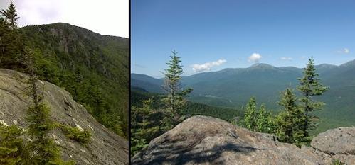
Join me for this impressive 12.8 mile hike with plenty of open views along the way. We'll ascend over Mt. Surprise (2194') on our way to the open summit of Mt. Moriah (4049') with its panoramic views in all directions. Upon descending Moriah, we'll continue along the AT (still the Carter-Moriah Trail) and descend along open ledges with beautiful views of the Carter and Presidential Ranges as well as the rugged back side of Moriah. On our way to North Carter we'll skirt around Imp Mountain as we glimpse the steep ascent of North Carter, which lies before us. At the steepest point of ascent there is an amazing view back towards Mt. Moriah just before the trail heads into the woods again. North Carter is mostly treed, but has a couple of ledges with views into the Wild River Wilderness and eastward into Maine. While North Carter is 4530 feet, it is not a recognized 4000-footer, as there is insufficient prominence to the neighboring Middle Carter. Afterwards, we'll descend via the Imp Face with its grand view of the Presidentials.
Total Distance and Elevation Gain: 12.8 miles and 4770 feet in elevation gain. NOTE: This is a strenuous+ hike with a steep ascent of North Carter and a short steep ascent of Moriah. The terrain otherwise is modest in grade for much of the hike.
Total Time: 8-9 hours or more depending on breaks and group's speed.
Rain or harsh weather will postpone until another date, as appropriate.
Camping Option: Contact me, if you're interested in camping Friday and/or Saturday night. I would be happy to set something up or provide details to share my site.
What to Bring: Typical summer hiking gear should be appropriate: convertible hiking pants or shorts, good sturdy hiking boots with thick socks, extra layer(s) (as needed) and a windbreaker/raingear (just in case). Also bring along lunch, snacks and plenty of water (at least 2-L). Optionally, pack bug repellent and sunscreen and anything else that you may require for a day hike.
Afterwards: We should be completed with the hike by 5:00/6:00PM. If there is sufficient interest, we can grab dinner/drinks at the Red Fox Bar and Grille in Jackson...or someplace to be determined in Gorham.
Directions
FROM THE NORTH: The trailhead is approximately 5.4 miles south of Gorham, NH along Route 16. FROM THE SOUTH: The trailhead is approximately 17.1 miles north of Glen, NH along Route 16.
The trailhead is well signed and is on the east side of the road.
For GPS Users: 44.322349,-71.217137 (trailhead).
Look for a grey Hyundai Elantra.
This hike requires car spotting...Once we've all met up, we'll drive to the other trailhead off Bangor Road in Gorham.
About this event
Join me for this impressive 12.8 mile hike with plenty of open views along the way. We'll ascend over Mt. Surprise (2194') on our way to the open summit of Mt. Moriah (4049') with its panoramic views in all directions. Upon descending Moriah, we'll continue along the AT (still the Carter-Moriah Trail) and descend along open ledges with beautiful views of the Carter and Presidential Ranges as well as the rugged back side of Moriah. On our way to North Carter we'll skirt around Imp Mountain as we glimpse the steep ascent of North Carter, which lies before us. At the steepest point of ascent there is an amazing view back towards Mt. Moriah just before the trail heads into the woods again. North Carter is mostly treed, but has a couple of ledges with views into the Wild River Wilderness and eastward into Maine. While North Carter is 4530 feet, it is not a recognized 4000-footer, as there is insufficient prominence to the neighboring Middle Carter. Afterwards, we'll descend via the Imp Face with its grand view of the Presidentials.
Total Distance and Elevation Gain: 12.8 miles and 4770 feet in elevation gain. NOTE: This is a strenuous+ hike with a steep ascent of North Carter and a short steep ascent of Moriah. The terrain otherwise is modest in grade for much of the hike.
Total Time: 8-9 hours or more depending on breaks and group's speed.
Rain or harsh weather will postpone until another date, as appropriate.
Camping Option: Contact me, if you're interested in camping Friday and/or Saturday night. I would be happy to set something up or provide details to share my site.
What to Bring: Typical summer hiking gear should be appropriate: convertible hiking pants or shorts, good sturdy hiking boots with thick socks, extra layer(s) (as needed) and a windbreaker/raingear (just in case). Also bring along lunch, snacks and plenty of water (at least 2-L). Optionally, pack bug repellent and sunscreen and anything else that you may require for a day hike.
Afterwards: We should be completed with the hike by 5:00/6:00PM. If there is sufficient interest, we can grab dinner/drinks at the Red Fox Bar and Grille in Jackson...or someplace to be determined in Gorham.
Directions to the trailhead
Get directionsFROM THE NORTH: The trailhead is approximately 5.4 miles south of Gorham, NH along Route 16. FROM THE SOUTH: The trailhead is approximately 17.1 miles north of Glen, NH along Route 16.
The trailhead is well signed and is on the east side of the road.
For GPS Users: 44.322349,-71.217137 (trailhead).
Look for a grey Hyundai Elantra.
This hike requires car spotting...Once we've all met up, we'll drive to the other trailhead off Bangor Road in Gorham.
Who's going (2)

Questions about this event?
Reach out to the host, shep5, for route details, carpooling, or what to bring.
Email the hostYou can also ask in the event discussion below.
Event discussion
No comments yet.
Log in to join the conversation.