Detour Travel Gay Travel Tours
All events Share Moderate to Strenuous

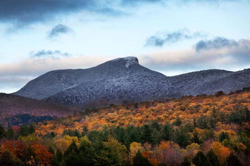
Camels Hump Fall Hike

This will be a Fall time hike up one of Vermonts Alpine mountains

Camels Hump Fall Hike

This will be a Fall time hike up one of Vermonts Alpine mountains

Details

We will be taking the Monroe trail, an approach to the summit from the East. From the Monroe trail the Alpine trail will be pick-up with two added bonus; multiple views of the Alpine summit and the viewing of WW2 error wreckage of a B-24 bomber. From the Alpine trail we will access the famous Vermont Long Trail from which the summit will be reached. The summit is an Alpine ecosystem which always presents an interesting array of plants, birds and insects. The descent will take us back down the Monroe trail. The approximate length of the hike is 6.1 miles with some rock scrambling and a 2,600ft gain in elevation. Also of note this time of year the Alpine summit can have frozen precipitation or conditions especially in the early part of the day. After the hike time for some brews....any suggestions?

Directions

Trailhead with coordinates:

3508 Camels Hump Rd
Duxbury, VT 05676

44.316264,-72.849565

The trailhead can be reached off I-89 at Exit 9 and by taking Rt. 2
west into Jonesville. At that point take a left onto Cochran and
another left at Duxbury Road. Turn right onto Camel's Hump Road and
proceed to the parking area.
Saturday, October 12, 2013
Duxbury, VT · Directions
Meet at 9:00 AM
Hosted by dewhurstt
5/15 signed up
Camels Hump Fall Hike

About this event

We will be taking the Monroe trail, an approach to the summit from the East. From the Monroe trail the Alpine trail will be pick-up with two added bonus; multiple views of the Alpine summit and the viewing of WW2 error wreckage of a B-24 bomber. From the Alpine trail we will access the famous Vermont Long Trail from which the summit will be reached. The summit is an Alpine ecosystem which always presents an interesting array of plants, birds and insects. The descent will take us back down the Monroe trail. The approximate length of the hike is 6.1 miles with some rock scrambling and a 2,600ft gain in elevation. Also of note this time of year the Alpine summit can have frozen precipitation or conditions especially in the early part of the day. After the hike time for some brews....any suggestions?

Directions to the trailhead

Get directions
Opens turn-by-turn directions to Duxbury, VT, 05676 in Google Maps (new tab).

Trailhead with coordinates:

3508 Camels Hump Rd
Duxbury, VT 05676

44.316264,-72.849565

The trailhead can be reached off I-89 at Exit 9 and by taking Rt. 2
west into Jonesville. At that point take a left onto Cochran and
another left at Duxbury Road. Turn right onto Camel's Hump Road and
proceed to the parking area.

Who's going (5)

shep5 GUEST MEMBER
shep5
Jaffrey, NH
HikerLegs SUSTAINING
HikerLegs
South Burlington, VT
wildcat GUEST MEMBER
wildcat
Portland, OR
georgep GUEST MEMBER
georgep
Hooksett, NH
TonyNH GUEST MEMBER
TonyNH
Grantham, NH

Questions about this event?

Questions for the host, dewhurstt, about route details, carpooling, or what to bring? Ask in the event discussion below.

Event discussion

vtfred · Oct 5, 2013
Arrgh! Called to work on this date, removing myself to reduce waitlist - have fun, guys! Best, Fred
HikerLegs · Oct 10, 2013
Just a reminder to try to carpool if you can. Camel's Hump is a very popular hike and I'm sure the trailhead parking lot will be very crowded. There are two parking lots for the Monroe Trail, the upper and lower lots, three tenths of a mile apart. The upper lot may be full, but if you park in the lower lot just walk the short distance to the upper lot and the Monroe trail head.

Log in to join the conversation.

Stay Connected with GayOutdoors

Receive outdoorsy tips, community updates, volunteer opportunities, event announcements, and trip reports.

We respect your privacy — unsubscribe anytime.