
Mt. Washington via Ammonoosuc ravine
Hike Mt. Washington via the Ammonoosuc ravine, and down the Jewell Trail
Mt. Washington via Ammonoosuc ravine
Hike Mt. Washington via the Ammonoosuc ravine, and down the Jewell Trail
Details
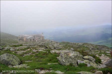
This is one of those classic hikes which while offering stunning views of Mt. Washington and the Presidentials, can be quite tough, and depending on weather, rather unforgiving. We will hike up the Ammonoosuc ravine trail, which starts at the train depot for the cog railway. This trail can be tough in sections, but it offers the most protected route up to the Lakes of the Clouds Hut, right below the summit of Mt. Washington. After a short break at the Hut, we will continue up to the summit for a short visit (you do not want to linger there, as it is full of tourists). From there we will continue down the Gulfside trail to the top of the Jewell Trail, and down back to the train depot. A good portion of this hike will be above treeline, and since we will be hiking to the top of the highest mountain in the Northeast (6,288 ft) we will be subjected to potentially quick changes in weather. Even in sunny weather, the Presidential ridge can be windy and chilly. So, come prepared, and carry a rain/wind proof parka, pants, and at least a medium fleece. You can buy food at the Hut and at the summit (and also fill up with water), but I recommend carrying your own food, and plenty of water. This is a strenuous hike, as the total mileage will be 9.6, with a 3,788 foot ascent. Please note that if the weather looks bad I will either cancel this hike, or turn back from the Hut if the AMC crew suggests doing so. (photos of the Lakes of the Clouds Hut and the summit, courtesy of the Mt. Washington Observatory website).
Directions
We will meet by the cog railway depot (by the museum entrance) at the end of Base Rd. The best way to get there is off Rt. 302 at Fabyan's. Whether coming from the north or the south, you will see Fabyan's restaurant and gas station at the junction of 302 with Base Rd. There will be a gigantic sign directing you to the cog railway, so make a turn onto Base Rd. as the sign directs you, and follow Base Rd. all the way to the end, where you will see the depot. There is parking at the depot, but is somewhat steep for hikers. About a mile prior to reaching the depot, there is a hikers parking lot which charges the usual WMNF $3. I plan to park at the train depot, and will meet all of you there. Feel free to park at the WMNF lot, as we can all ride my car back after finishing the hike. However, that means that you will still be adding another mile to this hike if you do so.
About this event
This is one of those classic hikes which while offering stunning views of Mt. Washington and the Presidentials, can be quite tough, and depending on weather, rather unforgiving. We will hike up the Ammonoosuc ravine trail, which starts at the train depot for the cog railway. This trail can be tough in sections, but it offers the most protected route up to the Lakes of the Clouds Hut, right below the summit of Mt. Washington. After a short break at the Hut, we will continue up to the summit for a short visit (you do not want to linger there, as it is full of tourists). From there we will continue down the Gulfside trail to the top of the Jewell Trail, and down back to the train depot. A good portion of this hike will be above treeline, and since we will be hiking to the top of the highest mountain in the Northeast (6,288 ft) we will be subjected to potentially quick changes in weather. Even in sunny weather, the Presidential ridge can be windy and chilly. So, come prepared, and carry a rain/wind proof parka, pants, and at least a medium fleece. You can buy food at the Hut and at the summit (and also fill up with water), but I recommend carrying your own food, and plenty of water. This is a strenuous hike, as the total mileage will be 9.6, with a 3,788 foot ascent. Please note that if the weather looks bad I will either cancel this hike, or turn back from the Hut if the AMC crew suggests doing so. (photos of the Lakes of the Clouds Hut and the summit, courtesy of the Mt. Washington Observatory website).
Directions to the trailhead
Get directionsWe will meet by the cog railway depot (by the museum entrance) at the end of Base Rd. The best way to get there is off Rt. 302 at Fabyan's. Whether coming from the north or the south, you will see Fabyan's restaurant and gas station at the junction of 302 with Base Rd. There will be a gigantic sign directing you to the cog railway, so make a turn onto Base Rd. as the sign directs you, and follow Base Rd. all the way to the end, where you will see the depot. There is parking at the depot, but is somewhat steep for hikers. About a mile prior to reaching the depot, there is a hikers parking lot which charges the usual WMNF $3. I plan to park at the train depot, and will meet all of you there. Feel free to park at the WMNF lot, as we can all ride my car back after finishing the hike. However, that means that you will still be adding another mile to this hike if you do so.
Who's going (4)
 SUSTAINING
 GUEST MEMBER
 GUEST MEMBER
 SUSTAINING
Questions about this event?
Reach out to the host, JPHiker, for route details, carpooling, or what to bring.
Email the hostYou can also ask in the event discussion below.
Event discussion
Log in to join the conversation.