
Mt. Flume/Liberty via Flume Slide Trail
Rock slides + exposed ledges + 2 four thousand footers + spectacular vistas + loop hike + fall foliage = ADVENTURE!
Mt. Flume/Liberty via Flume Slide Trail
Rock slides + exposed ledges + 2 four thousand footers + spectacular vistas + loop hike + fall foliage = ADVENTURE!
Details
Rock slides + exposed ledges + 2 four thousand footers + spectacular vistas + loop hike + fall foliage = ADVENTURE!!!
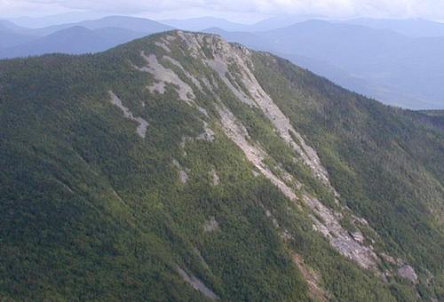
Flume Slide Trail is the most direct approach to the Mt. Flume Summit with the upper portion extremely steep and difficult as it follows the route of one of the mountain's old slides. Because many of the rock slabs which the route passes are extremely dangerous when wet, this route is not recommended in times of wet weather. Members not comfortable with such steep terrain are advised not to sign up. If you are a fast hiker and don't like to stick with the group either up or down, then please do not sign up. GROUP SAFETY IS OUR MOST IMPORTANT CONCERN.
Flume Slide to Summit
Appearing as a rocky pinnacle to drivers and passengers northbound on I-93 and US 3 beyond Lincoln, Mount Flume sets the style for the Franconia Ridge. Perhaps you've turned into the Flume Visitor Center for information and hiked into the Flume Gorge. We will actually be starting at the Flume Visitor Center and take the bike path to the Liberty Spring Trail.
The Liberty Spring Trail, a section of the Appalachian Trail, will take us up fairly steeply through a leafy forest, and in 0.5 mile we'll take a right on the Flume Slide Trail. We'll be descending using the Liberty Spring Trail making this a loop hike.Taking the Flume Slide Trail from this junction, we'll begin a woods walk for almost 3 miles to the base of the mountain.
For more than 0.5 mile, we'll face the side of the mountain where once an avalanche of rocks and gravel poured down. At the top of the slide we'll keep left as the trail enters spruces and firs, climbing to the junction with the Franconia Ridge Trail. We'll follow the Franconia Ridge Trail left up into the spruce scrub to the edge of open cliffs and reach the summit of 4,328 feet. Northward we'll see the barren and rocky crests of Mount Liberty, Mount Lincoln and Mount Lafayette, highest in the range.
Fraconia Ridge Trail to Mt. Lincoln/Liberty Springs Trail
We'll continue on to Mount Liberty [4,459 feet] down and up about 1.1 miles that overlooks the great forests to the east in the Pemigewasset Wilderness. Beyond the peak we'll descend a bit over 3.5 miles down the Liberty Spring Trail, to the bike path and then back to our cars.
Type: Loop
Duration: 8 hours
Elevation Gain: 3,367 feet
Mileage: 10 miles
This is not a dog friendly hike.
After The Hike: Everyone is welcome back at our house for dinner. Bring a change of clothing and take a shower to freshen up...we have plenty of towels. It's BYOB and the cost is $5 to pay for food costs.
Lodging Option: We have 8 bunks available with linen for Friday and/or Saturday night at our house in Waterville Valley for $20. You can use the kitchen facilities and store beverages/food in the fridge. I serve coffee in the morning and a continental breakfast. Contact me to RSVP. SPACE IS LIMITED TO EIGHT GUYS.
Directions
Take Exit 34A off the Franconia Notch Parkway. As you drive into the Flume Visitor Center, bear left to the north end parking area where the bike path begins. We'll be driving a blue Toyota FJ Cruiser.
About this event
Rock slides + exposed ledges + 2 four thousand footers + spectacular vistas + loop hike + fall foliage = ADVENTURE!!!
Flume Slide Trail is the most direct approach to the Mt. Flume Summit with the upper portion extremely steep and difficult as it follows the route of one of the mountain's old slides. Because many of the rock slabs which the route passes are extremely dangerous when wet, this route is not recommended in times of wet weather. Members not comfortable with such steep terrain are advised not to sign up. If you are a fast hiker and don't like to stick with the group either up or down, then please do not sign up. GROUP SAFETY IS OUR MOST IMPORTANT CONCERN.
Flume Slide to Summit
Appearing as a rocky pinnacle to drivers and passengers northbound on I-93 and US 3 beyond Lincoln, Mount Flume sets the style for the Franconia Ridge. Perhaps you've turned into the Flume Visitor Center for information and hiked into the Flume Gorge. We will actually be starting at the Flume Visitor Center and take the bike path to the Liberty Spring Trail.
The Liberty Spring Trail, a section of the Appalachian Trail, will take us up fairly steeply through a leafy forest, and in 0.5 mile we'll take a right on the Flume Slide Trail. We'll be descending using the Liberty Spring Trail making this a loop hike.Taking the Flume Slide Trail from this junction, we'll begin a woods walk for almost 3 miles to the base of the mountain.
For more than 0.5 mile, we'll face the side of the mountain where once an avalanche of rocks and gravel poured down. At the top of the slide we'll keep left as the trail enters spruces and firs, climbing to the junction with the Franconia Ridge Trail. We'll follow the Franconia Ridge Trail left up into the spruce scrub to the edge of open cliffs and reach the summit of 4,328 feet. Northward we'll see the barren and rocky crests of Mount Liberty, Mount Lincoln and Mount Lafayette, highest in the range.
Fraconia Ridge Trail to Mt. Lincoln/Liberty Springs Trail
We'll continue on to Mount Liberty [4,459 feet] down and up about 1.1 miles that overlooks the great forests to the east in the Pemigewasset Wilderness. Beyond the peak we'll descend a bit over 3.5 miles down the Liberty Spring Trail, to the bike path and then back to our cars.
Type: Loop
Duration: 8 hours
Elevation Gain: 3,367 feet
Mileage: 10 miles
This is not a dog friendly hike.
After The Hike: Everyone is welcome back at our house for dinner. Bring a change of clothing and take a shower to freshen up...we have plenty of towels. It's BYOB and the cost is $5 to pay for food costs.
Lodging Option: We have 8 bunks available with linen for Friday and/or Saturday night at our house in Waterville Valley for $20. You can use the kitchen facilities and store beverages/food in the fridge. I serve coffee in the morning and a continental breakfast. Contact me to RSVP. SPACE IS LIMITED TO EIGHT GUYS.
Directions to the trailhead
Get directionsTake Exit 34A off the Franconia Notch Parkway. As you drive into the Flume Visitor Center, bear left to the north end parking area where the bike path begins. We'll be driving a blue Toyota FJ Cruiser.
Who's going (4)
 SUSTAINING
 GUEST MEMBER
 GUEST MEMBER
 GUEST MEMBER
Questions about this event?
Reach out to the host, Gandalf, for route details, carpooling, or what to bring.
Email the hostYou can also ask in the event discussion below.
Event discussion
Log in to join the conversation.