
Mt Frissell Hike via Bear Mtn
A Hike to Mt Frissell, Bear Mountain and Round Mountain...taking in Connecticut's Highest Peak and Highpoint!
Mt Frissell Hike via Bear Mtn
A Hike to Mt Frissell, Bear Mountain and Round Mountain...taking in Connecticut's Highest Peak and Highpoint!
Details
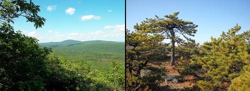
Join me for this hike over Connecticut's highest mountain, in addition to its high point. Bear Mountain, at an elevation of 2323 feet is the highest peak; however, the high point in the state is on the shoulder of Massachusetts' Mount Frissell (2454'). Along the way we'll also traverse the open summit of Round Mountain (2296'). There are views from the summits and ledges of all three, although Mt Frissell's summit is densely wooded (view points are provided on the approach). The trails used for this hike will weave in and out of Massachusetts and Connecticut. On the return we'll bypass the summit Bear Mountain, making this hike somewhat of a loop.
Distance and Elevation Gain: Approximately 9.6 miles and 2500 feet in elevation gain.
Rain or harsh weather will postpone until Sunday or another date, as appropriate.
What to Bring: Typical summer hiking gear should be appropriate: convertible hiking pants or shorts, good sturdy hiking boots with thick socks, extra layer(s) and a windbreaker/raingear (just in case). Also bring along lunch, snacks and plenty of water. Optionally, pack bug repellent and sunscreen and anything else that you may require for a day hike.
Afterwards: We should be completed with the hike by 4:00/5:00PM. If there is sufficient interest, we can grab dinner/drinks in Great Barrington or Salisbury, depending on the preferred direction and convenience of participants.
Directions
From the Mass Pike Exit 1 (West Stockbridge) take Route 41 South for 23.9 miles (approximately 35 minutes). The trailhead is on this road (also known as Undermountain Road in CT). It will be about 9.5 miles south of the MA/CT border. You will encounter Beaver Dam and Foot Hill Roads just prior to coming up on the trailhead.
From Salisbury, CT the trailhead will be approximately 3.4 miles along Route 41 North. It will be just beyond Westmount Road.
Look for a grey Hyundai Elantra.
About this event
Join me for this hike over Connecticut's highest mountain, in addition to its high point. Bear Mountain, at an elevation of 2323 feet is the highest peak; however, the high point in the state is on the shoulder of Massachusetts' Mount Frissell (2454'). Along the way we'll also traverse the open summit of Round Mountain (2296'). There are views from the summits and ledges of all three, although Mt Frissell's summit is densely wooded (view points are provided on the approach). The trails used for this hike will weave in and out of Massachusetts and Connecticut. On the return we'll bypass the summit Bear Mountain, making this hike somewhat of a loop.
Distance and Elevation Gain: Approximately 9.6 miles and 2500 feet in elevation gain.
Rain or harsh weather will postpone until Sunday or another date, as appropriate.
What to Bring: Typical summer hiking gear should be appropriate: convertible hiking pants or shorts, good sturdy hiking boots with thick socks, extra layer(s) and a windbreaker/raingear (just in case). Also bring along lunch, snacks and plenty of water. Optionally, pack bug repellent and sunscreen and anything else that you may require for a day hike.
Afterwards: We should be completed with the hike by 4:00/5:00PM. If there is sufficient interest, we can grab dinner/drinks in Great Barrington or Salisbury, depending on the preferred direction and convenience of participants.
Directions to the trailhead
Get directionsFrom the Mass Pike Exit 1 (West Stockbridge) take Route 41 South for 23.9 miles (approximately 35 minutes). The trailhead is on this road (also known as Undermountain Road in CT). It will be about 9.5 miles south of the MA/CT border. You will encounter Beaver Dam and Foot Hill Roads just prior to coming up on the trailhead.
From Salisbury, CT the trailhead will be approximately 3.4 miles along Route 41 North. It will be just beyond Westmount Road.
Look for a grey Hyundai Elantra.
Who's going (3)

Questions about this event?
Reach out to the host, shep5, for route details, carpooling, or what to bring.
Email the hostYou can also ask in the event discussion below.
Event discussion
Log in to join the conversation.