
Crane Mountain Loop Hike
A Picturesque Loop Hike around Crane Mountain and Crane Mountain Pond
Crane Mountain Loop Hike
A Picturesque Loop Hike around Crane Mountain and Crane Mountain Pond
Details
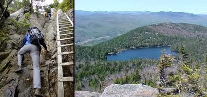
Join me for a modest 5 mile loop hike taking in the summit of Crane Mountain (3255') and the shores of the picturesque Crane Mountain Pond. This is a very popular mountain given the views from the top and its relative proximity to more populated areas in the Adirondacks. Along the way, there will be a very steep approach to the summit using a ladder (for those not wanting to try the raw rock scramble). On the summit there are good views into the surrounding area, as well as to the High Peaks to the north. We'll return off of the other side of the summit and descend down towards the shore of the pond and then return via the Putnam Brook Trail, where the trail goes over a natural stone bridge.
Distance and Elevation Gain: Approximately 5.0 miles and 1155 feet in elevation gain.
Rain or harsh weather will postpone until Sunday or another date, as appropriate.
What to Bring: Typical late spring/summer hiking gear should be appropriate: convertible hiking pants or shorts, good sturdy hiking boots with thick socks, extra layer(s) and a windbreaker/raingear (just in case). Also bring along lunch, snacks and plenty of water. Optionally, pack bug repellent and sunscreen and anything else that you may require for a day hike.
Afterwards: We should be completed with the hike by 2:00/2:30PM. If there is sufficient interest, we can get drinks or ice cream somewhere locally.
Directions
From the Northway (Route 87) take Exit 23 and head west on Route 9. In 0.8 miles, turn LEFT onto Richards Avenue and after crossing the Schroon River, turn RIGHT onto River Street (Route 418). After about 3.5 miles, turn RIGHT onto Athol Road (County Road 4). Follow this road as it changes to High Street and in another 3.5 miles turn RIGHT onto Mountain Road. In 4.1 miles and after the road changes to Valley Road, take a LEFT onto Garnet Lake Road. Follow this for 1.2 miles and veer RIGHT onto Ski Hill Road. The trailhead parking will be at the end of this road (DEC signs will lead you the rest of the way). Go slow, some of this road may be rough. Look for a grey Hyundai Elantra.
From the Northway in Warrensburg, it will take approximately 15.4 miles or 33 minutes.
For GPS users: The trailhead is at the end of Ski Hill Road in Johnsburg, NY (43.537661,-73.968043).
About this event
Join me for a modest 5 mile loop hike taking in the summit of Crane Mountain (3255') and the shores of the picturesque Crane Mountain Pond. This is a very popular mountain given the views from the top and its relative proximity to more populated areas in the Adirondacks. Along the way, there will be a very steep approach to the summit using a ladder (for those not wanting to try the raw rock scramble). On the summit there are good views into the surrounding area, as well as to the High Peaks to the north. We'll return off of the other side of the summit and descend down towards the shore of the pond and then return via the Putnam Brook Trail, where the trail goes over a natural stone bridge.
Distance and Elevation Gain: Approximately 5.0 miles and 1155 feet in elevation gain.
Rain or harsh weather will postpone until Sunday or another date, as appropriate.
What to Bring: Typical late spring/summer hiking gear should be appropriate: convertible hiking pants or shorts, good sturdy hiking boots with thick socks, extra layer(s) and a windbreaker/raingear (just in case). Also bring along lunch, snacks and plenty of water. Optionally, pack bug repellent and sunscreen and anything else that you may require for a day hike.
Afterwards: We should be completed with the hike by 2:00/2:30PM. If there is sufficient interest, we can get drinks or ice cream somewhere locally.
Directions to the trailhead
Get directionsFrom the Northway (Route 87) take Exit 23 and head west on Route 9. In 0.8 miles, turn LEFT onto Richards Avenue and after crossing the Schroon River, turn RIGHT onto River Street (Route 418). After about 3.5 miles, turn RIGHT onto Athol Road (County Road 4). Follow this road as it changes to High Street and in another 3.5 miles turn RIGHT onto Mountain Road. In 4.1 miles and after the road changes to Valley Road, take a LEFT onto Garnet Lake Road. Follow this for 1.2 miles and veer RIGHT onto Ski Hill Road. The trailhead parking will be at the end of this road (DEC signs will lead you the rest of the way). Go slow, some of this road may be rough. Look for a grey Hyundai Elantra.
From the Northway in Warrensburg, it will take approximately 15.4 miles or 33 minutes.
For GPS users: The trailhead is at the end of Ski Hill Road in Johnsburg, NY (43.537661,-73.968043).
Who's going (1)
 GUEST MEMBER
Questions about this event?
Reach out to the host, shep5, for route details, carpooling, or what to bring.
Email the hostYou can also ask in the event discussion below.
Event discussion
No comments yet.
Log in to join the conversation.