
Mts. Lafayette and Lincoln
Hike to one of the most magnificent peaks in the White Mountains!
Mts. Lafayette and Lincoln
Hike to one of the most magnificent peaks in the White Mountains!
Details
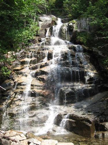
Mount Lafayette [5,260'], located just east of I-93 in Franconia Notch, is the crown jewel of the Franconia Ridge and the highest peak outside the Presidential Range. It is the sixth highest peak in New Hampshire's White Mountains and one of the most magnificent for hiking due to its dramatic ridge above treeline, excellent views and gorgeous waterfalls/cascade on the Falling Waters Trail.
Our favorite method of hiking Mount Lafayette is the Fraconia Ridge traverse that consists of a loop hike linking 3 summits [Lafayette, Lincoln [5089'] and Little Haystack [4780']. The itinerary starts and ends at Lafayette Place, the trailhead for the Old Bridle Path and Falling Waters Trail. Hiking north to south we will start at Lafayette Place [1780'] and head up the Old Bridle Path reaching Greenleaf Hut [4220'] in 2.9 miles.
From there we continue east 1.1 miles on the Greenleaf Trail to the summit of Mt. Lafayette. Leaving the summit, we travel south on the dramatic Franconia Ridge Trail 1.7 miles up and over Mount Lincoln and then to Little Haystack Mountain [4780']. We then hike down 3.2 miles on the Falling Waters Trail taking time to gaze at its amazing waterfalls and cascades back to Layatte Place.
This hike is rated strenuous because of its length, elevation gain and exposure above treeline. It's recommended for experienced hikers only. We recommend you carry at least 3 liters of water, lunch, snacks, light fleece, and rain protection.
Approximate length is 8.9 miles with 3,900' elevation gain. We will take breaks and have lunch on the summit. Because of the length we need to start by 9AM sharp.
After The Hike: Everyone is welcome back at our house in Waterville Valley to socialize around the deck and enjoy a home cooked meal with dessert! It's BYOB and it costs $5 per person.
Lodging Option: Bunk beds are available at my house near Waterville Valley, NH for Friday and Saturday night for $20 per night. Coffee/bagels each morning and linen/blankets/towels are provided. We have limited space in the fridge to store your beverages/food so it's best to bring a small cooler. Space is limited so email me ASAP to reserve a bunk!
Directions
Driving north on I-93 entering the Franconia Notch Parkway, note your mileage as you pass Exit 34A. Continue on the parkway for about 4 miles to an exit with signs for Trailhead Parking. If you are driving south on the Parkway, take the exit for the Lafayette Place Campground and Trailhead Parking, about 2 miles south of Exit 34B for the Cannon Mountain Tramway. A pedestrain underpass connects parking on either side of the parkway. We are driving a blue FJ Cruiser and will meet you at the trailhead.
About this event
Mount Lafayette [5,260'], located just east of I-93 in Franconia Notch, is the crown jewel of the Franconia Ridge and the highest peak outside the Presidential Range. It is the sixth highest peak in New Hampshire's White Mountains and one of the most magnificent for hiking due to its dramatic ridge above treeline, excellent views and gorgeous waterfalls/cascade on the Falling Waters Trail.
Our favorite method of hiking Mount Lafayette is the Fraconia Ridge traverse that consists of a loop hike linking 3 summits [Lafayette, Lincoln [5089'] and Little Haystack [4780']. The itinerary starts and ends at Lafayette Place, the trailhead for the Old Bridle Path and Falling Waters Trail. Hiking north to south we will start at Lafayette Place [1780'] and head up the Old Bridle Path reaching Greenleaf Hut [4220'] in 2.9 miles.
From there we continue east 1.1 miles on the Greenleaf Trail to the summit of Mt. Lafayette. Leaving the summit, we travel south on the dramatic Franconia Ridge Trail 1.7 miles up and over Mount Lincoln and then to Little Haystack Mountain [4780']. We then hike down 3.2 miles on the Falling Waters Trail taking time to gaze at its amazing waterfalls and cascades back to Layatte Place.
This hike is rated strenuous because of its length, elevation gain and exposure above treeline. It's recommended for experienced hikers only. We recommend you carry at least 3 liters of water, lunch, snacks, light fleece, and rain protection.
Approximate length is 8.9 miles with 3,900' elevation gain. We will take breaks and have lunch on the summit. Because of the length we need to start by 9AM sharp.
After The Hike: Everyone is welcome back at our house in Waterville Valley to socialize around the deck and enjoy a home cooked meal with dessert! It's BYOB and it costs $5 per person.
Lodging Option: Bunk beds are available at my house near Waterville Valley, NH for Friday and Saturday night for $20 per night. Coffee/bagels each morning and linen/blankets/towels are provided. We have limited space in the fridge to store your beverages/food so it's best to bring a small cooler. Space is limited so email me ASAP to reserve a bunk!
Directions to the trailhead
Get directionsDriving north on I-93 entering the Franconia Notch Parkway, note your mileage as you pass Exit 34A. Continue on the parkway for about 4 miles to an exit with signs for Trailhead Parking. If you are driving south on the Parkway, take the exit for the Lafayette Place Campground and Trailhead Parking, about 2 miles south of Exit 34B for the Cannon Mountain Tramway. A pedestrain underpass connects parking on either side of the parkway. We are driving a blue FJ Cruiser and will meet you at the trailhead.
Who's going (5)
 SUSTAINING
 SUSTAINING
 SUSTAINING
 GUEST MEMBER
Questions about this event?
Reach out to the host, Gandalf, for route details, carpooling, or what to bring.
Email the hostYou can also ask in the event discussion below.
Event discussion
Log in to join the conversation.