
Mt Roberts Hike
Hiking Mt Roberts @ Castle in the Clouds
Details
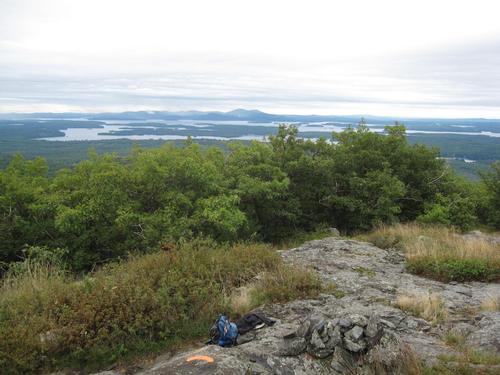
Please join me for my annual NH spring hike, still in the Ossipee Mtns but this year hiking to the 2582' summit of Mt Roberts. We'll hike up to the east of the peak and aproach it from the north; then descend via a series of ledges with spectacular views of Lake Winnipesaukee. Total walking distance should be 6+ miles, total elevation gain around 1500'. Please bring water, snacks + lunch; wear sturdy walking shoes/boots and clothing appropriate for the weather conditions that day.
Directions
We'll meet in the parking lot on the right hand side just inside the bus tour gate house entrance to Castle in the Clouds property:
From Rt. 16:
- From Rt. 16 in Ossipee, take Rt. 171 west (Old Granite Road which turns into Water Village Road and then Mountain Road after crossing route 28).
- After crossing Route 28, stay on Rte 171 for 13 miles to Ossipee Park Road; this will be about 2 miles past the original (now car tourist) entrance to Castle in the Clouds.
- Turn right onto Ossipee Park Road and proceed steadily and sometimes steeply up for about 1.2 miles to the parking area.
From I-93:
- Take exit 23 off of I-93 and follow Rt. 104 east for about 8 miles until it ends in Meredith.
- Turn left onto Rt. 3 and go about 0.8 mile to a traffic light just beyond the public docks.
- Turn right onto Rt. 25 and travel 10.1 miles passing through Moltonborough village.
- Turn right onto Rt. 109 and go 2.2 miles.
- Turn left onto Rt. 171 east and proceed for half a mile.
- Turn left onto Ossipee Park Road and proceed steadily and sometimes steeply up for about 1.2 miles to the parking area.
About this event
Please join me for my annual NH spring hike, still in the Ossipee Mtns but this year hiking to the 2582' summit of Mt Roberts. We'll hike up to the east of the peak and aproach it from the north; then descend via a series of ledges with spectacular views of Lake Winnipesaukee. Total walking distance should be 6+ miles, total elevation gain around 1500'. Please bring water, snacks + lunch; wear sturdy walking shoes/boots and clothing appropriate for the weather conditions that day.
Directions to the trailhead
Get directionsWe'll meet in the parking lot on the right hand side just inside the bus tour gate house entrance to Castle in the Clouds property:
From Rt. 16:
- From Rt. 16 in Ossipee, take Rt. 171 west (Old Granite Road which turns into Water Village Road and then Mountain Road after crossing route 28).
- After crossing Route 28, stay on Rte 171 for 13 miles to Ossipee Park Road; this will be about 2 miles past the original (now car tourist) entrance to Castle in the Clouds.
- Turn right onto Ossipee Park Road and proceed steadily and sometimes steeply up for about 1.2 miles to the parking area.
From I-93:
- Take exit 23 off of I-93 and follow Rt. 104 east for about 8 miles until it ends in Meredith.
- Turn left onto Rt. 3 and go about 0.8 mile to a traffic light just beyond the public docks.
- Turn right onto Rt. 25 and travel 10.1 miles passing through Moltonborough village.
- Turn right onto Rt. 109 and go 2.2 miles.
- Turn left onto Rt. 171 east and proceed for half a mile.
- Turn left onto Ossipee Park Road and proceed steadily and sometimes steeply up for about 1.2 miles to the parking area.
Who's going (9)
 SUSTAINING
 SUSTAINING
 SUSTAINING
 GUEST MEMBER
 GUEST MEMBER
 SUSTAINING
 GUEST MEMBER
Questions about this event?
Reach out to the host, jonathanclark, for route details, carpooling, or what to bring.
Email the hostYou can also ask in the event discussion below.
Event discussion
Log in to join the conversation.