
Mt. Osceola/East Peak Hike
<p>Join me on my last WINTER 4,000 footer...Mt. Osceola! This trip has two 4,000 footers.</p>
Mt. Osceola/East Peak Hike
<p>Join me on my last WINTER 4,000 footer...Mt. Osceola! This trip has two 4,000 footers.</p>
Details
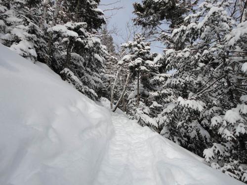
On this trip we will hike to East Osceolas (4,156' #34) and Mt Osceola (4340' #24) using the Greeley Pond trail off the Kancamagus Highway. Mount Osceola is among one the most climbed mountains in the Southern White Mountains. Though Mt. Osceola never reaches timberline, the two views from the summit are spectacular. East Peak on the other hand, does not have any views.
On any given clear, high visibility day you can see forty one of the of the other 4000's in New Hampshire from Mount Osceola and even faintly see Mt. Mansfield towards the west. We will be coming from the east and this climb can be very tough. At time the trail here can become Class 2 especially on part of the way up East Osceola and a section of the trail called the chimney between East Osceola and Mount Osceola. An ice axe is helpful but not necessary.
This is a moderate pace trip we will hike about 7.6 miles round trip with an elevation gain of 3232 ft. Book time is 5 hours 25 minutes not including breaks.
It could be cold and windy, it could snow, or it could be warm with blue skies. You will need warm layers, wind protection, traction, snowshoes among other things. Read my Winter Hiking 101 Article. If you don't know what to wear and/or bring with you or have any questions contact us. Do not rely on others to have extra items to share with you at the meeting spot or on the trail. You should know how to use all of your equipment - test and adjust it prior to this trip.
Dogs are permitted on this hike provided they are experienced "hikers", well-behaved, you bring a leash in case you need to use it, and you have a copy of their most recent rabies vaccination. Be sure to indicate in your RSVP if you will be bringing a dog.
This event is considered to be STRENUOUS because of the pace, distance, and elevation gain. We could alter our plans because of fatigue, weather, and/or other conditions and there is no guarantee that we will complete the entire event as described here (i.e. we might not reach the summit).
I did my research using the Appalachian Mountain Club's "White Mountain Guide", a trail map, and the Internet. You need to become self-reliant by becoming familiar with the route, terrain, and potential hazards since you are ultimately responsible for your own safety. >>Click Here For Current Trail Conditions
Weather
It is winter in the mountains - expect cold and windy conditions. Temperatures drop 3-5 degrees for every 1,000 feet of elevation gained. Dangerous weather conditions will cancel this hike - We will post an and/or send an email to all confirmed participants a day or two before this event. Mountain weather is subject to rapid changes and extreme conditions. We will assess travel and weather conditions during the hike and make changes to our planned trip as necessary. >>Click Here For Current Weather Forecast For This Trip
After The Hike: Everyone is welcome back at our house in Waterville Valley to socialize around the fireplace and enjoy a home cooked meal with dessert! It's BYOB and it costs $5 per person.
Lodging Option: Bunk beds are available at our house near Waterville Valley, NH for Friday and/or Saturday night for $20 per night. Coffee/bagels each morning and linen/blankets/towels are provided. We have limited space in the fridge to store your beverages/food so it's best to bring a small cooler. Space is limited so email me ASAP to reserve a bunk!
Directions
We will begin this hike by meeting at Greeley Pond Trailhead at 10 AM. According to Google Maps this meeting spot is about 141 miles from Boston and it should take about, 2 hours 28 mins minutes to drive there.
Click Here for directions to the trailhead. [Enter your address as the point of departure.]
About this event
On this trip we will hike to East Osceolas (4,156' #34) and Mt Osceola (4340' #24) using the Greeley Pond trail off the Kancamagus Highway. Mount Osceola is among one the most climbed mountains in the Southern White Mountains. Though Mt. Osceola never reaches timberline, the two views from the summit are spectacular. East Peak on the other hand, does not have any views.
On any given clear, high visibility day you can see forty one of the of the other 4000's in New Hampshire from Mount Osceola and even faintly see Mt. Mansfield towards the west. We will be coming from the east and this climb can be very tough. At time the trail here can become Class 2 especially on part of the way up East Osceola and a section of the trail called the chimney between East Osceola and Mount Osceola. An ice axe is helpful but not necessary.
This is a moderate pace trip we will hike about 7.6 miles round trip with an elevation gain of 3232 ft. Book time is 5 hours 25 minutes not including breaks.
It could be cold and windy, it could snow, or it could be warm with blue skies. You will need warm layers, wind protection, traction, snowshoes among other things. Read my Winter Hiking 101 Article. If you don't know what to wear and/or bring with you or have any questions contact us. Do not rely on others to have extra items to share with you at the meeting spot or on the trail. You should know how to use all of your equipment - test and adjust it prior to this trip.
Dogs are permitted on this hike provided they are experienced "hikers", well-behaved, you bring a leash in case you need to use it, and you have a copy of their most recent rabies vaccination. Be sure to indicate in your RSVP if you will be bringing a dog.
This event is considered to be STRENUOUS because of the pace, distance, and elevation gain. We could alter our plans because of fatigue, weather, and/or other conditions and there is no guarantee that we will complete the entire event as described here (i.e. we might not reach the summit).
I did my research using the Appalachian Mountain Club's "White Mountain Guide", a trail map, and the Internet. You need to become self-reliant by becoming familiar with the route, terrain, and potential hazards since you are ultimately responsible for your own safety. >>Click Here For Current Trail Conditions
Weather
It is winter in the mountains - expect cold and windy conditions. Temperatures drop 3-5 degrees for every 1,000 feet of elevation gained. Dangerous weather conditions will cancel this hike - We will post an and/or send an email to all confirmed participants a day or two before this event. Mountain weather is subject to rapid changes and extreme conditions. We will assess travel and weather conditions during the hike and make changes to our planned trip as necessary. >>Click Here For Current Weather Forecast For This Trip
After The Hike: Everyone is welcome back at our house in Waterville Valley to socialize around the fireplace and enjoy a home cooked meal with dessert! It's BYOB and it costs $5 per person.
Lodging Option: Bunk beds are available at our house near Waterville Valley, NH for Friday and/or Saturday night for $20 per night. Coffee/bagels each morning and linen/blankets/towels are provided. We have limited space in the fridge to store your beverages/food so it's best to bring a small cooler. Space is limited so email me ASAP to reserve a bunk!
Directions to the trailhead
Get directionsWe will begin this hike by meeting at Greeley Pond Trailhead at 10 AM. According to Google Maps this meeting spot is about 141 miles from Boston and it should take about, 2 hours 28 mins minutes to drive there.
Click Here for directions to the trailhead. [Enter your address as the point of departure.]
Who's going (2)
 SUSTAINING
Questions about this event?
Reach out to the host, Gandalf, for route details, carpooling, or what to bring.
Email the hostYou can also ask in the event discussion below.
Event discussion
Log in to join the conversation.