
Hancock Loop Hike
<p>A moderate early fall, double peak bagger in the Pemi Wilderness. A great opportunity for those beginning or completing their NH 4K footers.</p>
Hancock Loop Hike
<p>A moderate early fall, double peak bagger in the Pemi Wilderness. A great opportunity for those beginning or completing their NH 4K footers.</p>
Details
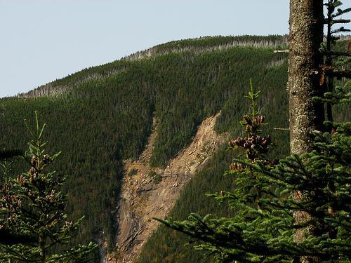
The Hancocks, North (4420') & South (4319") Peaks, are two official 4000 footers, which lie by themselves between Mt. Carrigan and the Pemigewasset Wilderness, just north of the Kancamagus Highway. Although neither peak promises great views from their wooded summits, there are several outlooks along the loop that offer a bowlful of eye candy. The experience is often touted as being more "Zen-like" than picturesque and the timing of this hike is almost surely to be in prime NE foliage season. As you climb you glimpse many familiar peaks around you, and the views you get give you the challenge of trying to figure out which mountains you have in sight. There is also a panoramic view towards the west and northwest from the lookout on the North Peak. The approach is easy to moderate, with a short but steep (strenuous) climb near the summits. The distance for this trip is 9.8 mile with an accumulative elevation gain of 2650'. The trail to these mountains is a loop trail known as the Hancock Loop Trail, which is reached from the Cedar Brook Trail and Hancock Notch Trail, starting at the Kancamagus Highway parking area as follows:
Hancock Notch Trail This trail leads from the Kancamagus Highway to the Sawyer River Road. For the Hancocks, follow this trail 1.8 miles to the Cedar Brook Trail. The trail has a gentle grade this entire length.
Cedar Brook Trail This trail leads from the Hancock Notch Trail to the Wilderness Trail in the Pemigewasset Wilderness. From the Hancock Notch Trail, follow the Cedar Brook trail .7 miles to the Hancock Loop Trail. This trail also has a gentle grade, with five stream crossings.
Hancock Loop Trial Actually, this is a lolipop trail. It rises gently (600 feet) for 1.1 miles to the trail split. To North Hancock, the trail runs .8 miles (1,150 feet) to the summit. To South Hancock the trail rises .5 miles (1,000 feet) to the summit. The trail runs 1.4 miles between the peaks, and rises and falls over three small false summits.
What toWear/ Bring: Lunch, high energy snacks and plenty (3L) of water. Sturdy hiking footwear and appropriate fall hiking apparel recommended. Avoid cotton/denim, bring rain gear in case of a sudden shower and plan for cooler temps with light layers. A small flashlight or headlamp, first aid kit and firestarter are also helpful for this type of hike.
Directions
From the west: Take exit 32 off I93 onto Route 112 east (Kancamagus Highway) in Lincoln. Follow R112 for about 11 miles to the Hancock Overlook area just after the hairpin turn. From the east: Following Route 16 (Spalding Turnpike) turn onto Route 112 west (Kancamagus Highway) in Conway. Follow R112 for about 23.5 miles to the Hancock Overlook area just before the hairpin turn. We will meet at the Hancock Overlook Pavilion. I will be driving a Gray Nissan Cube.
About this event
The Hancocks, North (4420') & South (4319") Peaks, are two official 4000 footers, which lie by themselves between Mt. Carrigan and the Pemigewasset Wilderness, just north of the Kancamagus Highway. Although neither peak promises great views from their wooded summits, there are several outlooks along the loop that offer a bowlful of eye candy. The experience is often touted as being more "Zen-like" than picturesque and the timing of this hike is almost surely to be in prime NE foliage season. As you climb you glimpse many familiar peaks around you, and the views you get give you the challenge of trying to figure out which mountains you have in sight. There is also a panoramic view towards the west and northwest from the lookout on the North Peak. The approach is easy to moderate, with a short but steep (strenuous) climb near the summits. The distance for this trip is 9.8 mile with an accumulative elevation gain of 2650'. The trail to these mountains is a loop trail known as the Hancock Loop Trail, which is reached from the Cedar Brook Trail and Hancock Notch Trail, starting at the Kancamagus Highway parking area as follows:
Hancock Notch Trail This trail leads from the Kancamagus Highway to the Sawyer River Road. For the Hancocks, follow this trail 1.8 miles to the Cedar Brook Trail. The trail has a gentle grade this entire length.
Cedar Brook Trail This trail leads from the Hancock Notch Trail to the Wilderness Trail in the Pemigewasset Wilderness. From the Hancock Notch Trail, follow the Cedar Brook trail .7 miles to the Hancock Loop Trail. This trail also has a gentle grade, with five stream crossings.
Hancock Loop Trial Actually, this is a lolipop trail. It rises gently (600 feet) for 1.1 miles to the trail split. To North Hancock, the trail runs .8 miles (1,150 feet) to the summit. To South Hancock the trail rises .5 miles (1,000 feet) to the summit. The trail runs 1.4 miles between the peaks, and rises and falls over three small false summits.
What toWear/ Bring: Lunch, high energy snacks and plenty (3L) of water. Sturdy hiking footwear and appropriate fall hiking apparel recommended. Avoid cotton/denim, bring rain gear in case of a sudden shower and plan for cooler temps with light layers. A small flashlight or headlamp, first aid kit and firestarter are also helpful for this type of hike.
Directions to the trailhead
Get directionsFrom the west: Take exit 32 off I93 onto Route 112 east (Kancamagus Highway) in Lincoln. Follow R112 for about 11 miles to the Hancock Overlook area just after the hairpin turn. From the east: Following Route 16 (Spalding Turnpike) turn onto Route 112 west (Kancamagus Highway) in Conway. Follow R112 for about 23.5 miles to the Hancock Overlook area just before the hairpin turn. We will meet at the Hancock Overlook Pavilion. I will be driving a Gray Nissan Cube.
Who's going (2)
 SUSTAINING
 GUEST MEMBER
Questions about this event?
Questions for the host, PineRiverPonder, about route details, carpooling, or what to bring? Ask in the event discussion below.
Event discussion
Log in to join the conversation.