
HE Travel Gay Travel Tours
All events Share Moderate

Great Smoky Mtn Natl Park- Big Creek Tr

<p><strong>Great Smoky Mtn Natl Park backpack to Walnut Bottoms backcountry campsite 37 for the weekend of September 8th and 9th.&nbsp;</strong></p>

Great Smoky Mtn Natl Park- Big Creek Tr

<p><strong>Great Smoky Mtn Natl Park backpack to Walnut Bottoms backcountry campsite 37 for the weekend of September 8th and 9th.&nbsp;</strong></p>

Details

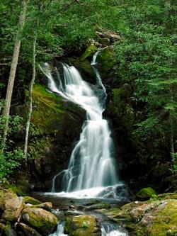
I have 5 backcountry camping spot permits reserved in the Big Creek area of the Great Smoky Mountain National Park for Saturday, September 8th and Sunday, September 9th. Big Creek is located right at the Tennessee and North Carolina border taking the Waterville exit (exit 451) off of Highway 40. The Big Creek Trail is 5.2 miles to backcountry group campsite 37. Along the trail is the popular swimming hole, Midnight Hole and the 45 foot tall Mouse Creek Falls with the hike gradually ascending never venturing from the sight and sound of rushing rapids and many more swimming holes. With the elevation gain of 1,300 foot spread out over 5 miles, it is a relatively gradual ascent to Walnut Bottoms which is the place to camp if you want to see bears. Walnut Bottoms is also the home to "Jumper" the bear. Jumper has been known to jump on to hanging packs in order to steal food. So, be bear prepared! Camp has bear pulleys and clips in place to hang our food out of reach. With so many beautiful sights it is a classic Smokies hike that shouldn't be raced or rushed through and hope to keep a casual pace. Today while hiking the same route, the water was so clear you could read a newspaper from the bottom of the stream over 20 foot below surface. Just one range over, in Cataloochee, they have reintroduced elk into the park which could hopefully be seen also. Many other hiking trails, geologic formations, swimming holes, waterfalls and preserved pioneer settlements in the immediate area make for potential side trips for those so inclined also. There is also whitewater rafting and horseback riding leaving from the same exit off of 40. I will have some room in the Jeep to carpool from Asheville, North Carolina. The plan is to leave the trailhead around 09:00 AM on Saturday.There are no dogs allowed anywhere in the GSMNP. Please reserve spot as i only have limited permits, thanks.
It had been really nice meeting some of my GObuds that were able, and also unable to go on my last backpack to Lost Cove / Gragg Prong. Hopefully by also posting this to the entire group along with some individual invitations it will allow more of us to meet and have a fantastic weekend in the deep forest together. Looking forward to hearing from you all! ~peace~
Chan

Directions

We will meet at the Big Creek Trail parking lot. The Big Creek area is accessed from the Waterville, TN exit 451 on Interstate 40, right near the border of North Carolina and Tennessee in the Great Smoky Mtn Natl Park. Take a left at end of exit 451 back under the interstate and follow until taking a left over a bridge and following the Pigeon River upstream. You will pass an old Progress Energy power plant and playground. Continue on aproximately 4 miles past an intersection with a tiny store going straight into the GSMNP. Follow past the big creek ranger station until it ends at parking lot for Big Creek Trail and tent campsites. I will be in my black Jeep Wrangler.
Saturday, September 8, 2012
Asheville, NC · Directions
Meet at 9:00 AM
Hosted by sos13
1/5 signed up
Great Smoky Mtn Natl Park- Big Creek Tr

About this event

I have 5 backcountry camping spot permits reserved in the Big Creek area of the Great Smoky Mountain National Park for Saturday, September 8th and Sunday, September 9th. Big Creek is located right at the Tennessee and North Carolina border taking the Waterville exit (exit 451) off of Highway 40. The Big Creek Trail is 5.2 miles to backcountry group campsite 37. Along the trail is the popular swimming hole, Midnight Hole and the 45 foot tall Mouse Creek Falls with the hike gradually ascending never venturing from the sight and sound of rushing rapids and many more swimming holes. With the elevation gain of 1,300 foot spread out over 5 miles, it is a relatively gradual ascent to Walnut Bottoms which is the place to camp if you want to see bears. Walnut Bottoms is also the home to "Jumper" the bear. Jumper has been known to jump on to hanging packs in order to steal food. So, be bear prepared! Camp has bear pulleys and clips in place to hang our food out of reach. With so many beautiful sights it is a classic Smokies hike that shouldn't be raced or rushed through and hope to keep a casual pace. Today while hiking the same route, the water was so clear you could read a newspaper from the bottom of the stream over 20 foot below surface. Just one range over, in Cataloochee, they have reintroduced elk into the park which could hopefully be seen also. Many other hiking trails, geologic formations, swimming holes, waterfalls and preserved pioneer settlements in the immediate area make for potential side trips for those so inclined also. There is also whitewater rafting and horseback riding leaving from the same exit off of 40. I will have some room in the Jeep to carpool from Asheville, North Carolina. The plan is to leave the trailhead around 09:00 AM on Saturday.There are no dogs allowed anywhere in the GSMNP. Please reserve spot as i only have limited permits, thanks.
It had been really nice meeting some of my GObuds that were able, and also unable to go on my last backpack to Lost Cove / Gragg Prong. Hopefully by also posting this to the entire group along with some individual invitations it will allow more of us to meet and have a fantastic weekend in the deep forest together. Looking forward to hearing from you all! ~peace~
Chan

Directions to the trailhead

Get directions
Opens turn-by-turn directions to Asheville, NC, 28814 in Google Maps (new tab).

We will meet at the Big Creek Trail parking lot. The Big Creek area is accessed from the Waterville, TN exit 451 on Interstate 40, right near the border of North Carolina and Tennessee in the Great Smoky Mtn Natl Park. Take a left at end of exit 451 back under the interstate and follow until taking a left over a bridge and following the Pigeon River upstream. You will pass an old Progress Energy power plant and playground. Continue on aproximately 4 miles past an intersection with a tiny store going straight into the GSMNP. Follow past the big creek ranger station until it ends at parking lot for Big Creek Trail and tent campsites. I will be in my black Jeep Wrangler.

Who's going (1)

A member
Profile hidden

Questions about this event?

Questions for the host, sos13, about route details, carpooling, or what to bring? Ask in the event discussion below.

Event discussion

No comments yet.

Log in to join the conversation.

Stay Connected with GayOutdoors

Receive outdoorsy tips, community updates, volunteer opportunities, event announcements, and trip reports.

We respect your privacy — unsubscribe anytime.