
All events
Share
Moderate
Los Liones Trail to Parker Mesa Overlook
<p><b><span style="font-size: 11pt; line-height: 115%; font-family: Arial; ">Beautiful Lush Canyon and Great Views of Pacific Ocean</span></b><!-EndFr-></p>
Los Liones Trail to Parker Mesa Overlook
<p><b><span style="font-size: 11pt; line-height: 115%; font-family: Arial; ">Beautiful Lush Canyon and Great Views of Pacific Ocean</span></b><!-EndFr-></p>
Details
Date: September 16, 2012
Time: 9:00 am
Near: Pacific Palisades, CA 90272
Distance: 7.2 miles round trip
Difficulty: Moderate
Elevation Gain: 1300 feet
Hike Time: 4.0 hours
Trail Type: Well maintained trail
Hike Type: Out and Back
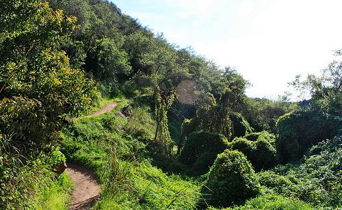
Summary: Los Liones Trail weaves through one of the lushest canyons in the Santa Monica Mountains. The trail meanders and ascends through chaparral and ivy covered trees and bushes. In parts, the entire canyon floor is covered in a carpet of ivy. The trail meets up with the system of fire roads in Topanga State Park, and makes a relentless ascent to Parker Mesa - 1525ft. On a clear day, you’ll get amazing panoramic views of the Santa Monica Bay, and often inland as far as the San Bernardino Mountains.
Directions
Trailhead: How To get There: From the Pacific Coast Highway, turn east onto Sunset Blvd. and left onto Los Liones Drive after 0.3 miles (the turn comes up quick, and it’s not a major intersection – so be careful!). The trailhead is clearly marked about 0.6 miles down Los Liones Drive. You do not need to pay to park on the street inside Topanga State Park here. We will meet at the trailhead at the end of the road.
What to Bring: Good hiking boots/shoes, snacks/lunch, plentyof water, hat/cap and sunscreen.
About this event
Date: September 16, 2012
Time: 9:00 am
Near: Pacific Palisades, CA 90272
Distance: 7.2 miles round trip
Difficulty: Moderate
Elevation Gain: 1300 feet
Hike Time: 4.0 hours
Trail Type: Well maintained trail
Hike Type: Out and Back
Summary: Los Liones Trail weaves through one of the lushest canyons in the Santa Monica Mountains. The trail meanders and ascends through chaparral and ivy covered trees and bushes. In parts, the entire canyon floor is covered in a carpet of ivy. The trail meets up with the system of fire roads in Topanga State Park, and makes a relentless ascent to Parker Mesa - 1525ft. On a clear day, you’ll get amazing panoramic views of the Santa Monica Bay, and often inland as far as the San Bernardino Mountains.
Directions to the trailhead
Get directions Opens turn-by-turn directions to Pacific Palisades, CA, 90272 in Google Maps (new tab).
Trailhead: How To get There: From the Pacific Coast Highway, turn east onto Sunset Blvd. and left onto Los Liones Drive after 0.3 miles (the turn comes up quick, and it’s not a major intersection – so be careful!). The trailhead is clearly marked about 0.6 miles down Los Liones Drive. You do not need to pay to park on the street inside Topanga State Park here. We will meet at the trailhead at the end of the road.
What to Bring: Good hiking boots/shoes, snacks/lunch, plentyof water, hat/cap and sunscreen.
Who's going (2)


Questions about this event?
Questions for the host, Menard, about route details, carpooling, or what to bring? Ask in the event discussion below.
Event discussion
No comments yet.
Log in to join the conversation.