
Wildcat Range
<p><span class="Apple-style-span" style="font-family: Verdana; ">Wildcat Traverse offering dramatic views of the Presidentials</span></p>
Wildcat Range
<p><span class="Apple-style-span" style="font-family: Verdana; ">Wildcat Traverse offering dramatic views of the Presidentials</span></p>
Details
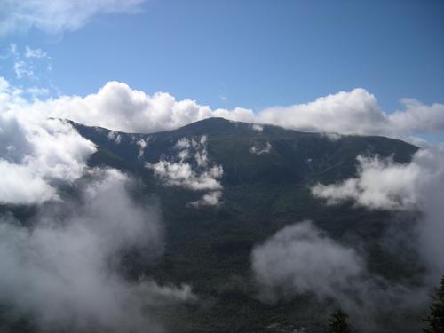
Trail Description: The Wildcat range offers some of the most dramatic views of Mt. Washington (see pic, taken right after a T-storm from Wildcat D). It traverses 5 peaks including two 4000 footers (Wildcat A & D).
The ascent to Wildcat E is very steep and quite long (actually considered one of the most strenuous climbs of the AT by thru-hikers), but the reward are the many ledges along the way offering the most scenic views of the Presidentials, including Tuckerman and Huntington ravines. Hiking time will be longer than the length of the trail or maps might suggest.
After spotting cars we'll start at the Glen Ellis parking lot. After a brief visit to Glen Ellis falls we'll take the AT to the top of Wildcat E. This is a long and strenuous climb over exposed rock. The AT then follows the Wildcat ridge over the various Wildcat peaks before descending steeply into Carter Notch. Depending on the group we might take a brief detour to Carter Notch Hut. From the Notch we'll hike out on the easier 19 Mile Brook trail.
Bring a lunch and plenty of water. We might experience the first fall like weather in late August, so bring an extra layer just in case. Total distance is 8.7 miles with and elevation gain of 3200 ft taking approximately 7 hours.
P.S.: On Aug. 23, 2003 I met two SOBO AT thru-hikers on top of Wildcat and that's where I go my trailname "Wildcat". Four years later I was thru-hiking. This is an anniversary hike for me and I thought it would be a great event for the GO community.
After the hike: We'll stop at the Red Fox Pub in Jackson, NH for Pub & Grub.
Directions
From North Conway, drive north on NH 16 past Pinkham Notch. The Nineteen Mile Brook traihead is on the right, 3.5 miles north of Pinkham Notch. It's a decent size parking lot and usually has a few vehicles parked. We'll spot cars after the group meets. Look for a silver Toyota Rav4.
About this event
Trail Description: The Wildcat range offers some of the most dramatic views of Mt. Washington (see pic, taken right after a T-storm from Wildcat D). It traverses 5 peaks including two 4000 footers (Wildcat A & D).
The ascent to Wildcat E is very steep and quite long (actually considered one of the most strenuous climbs of the AT by thru-hikers), but the reward are the many ledges along the way offering the most scenic views of the Presidentials, including Tuckerman and Huntington ravines. Hiking time will be longer than the length of the trail or maps might suggest.
After spotting cars we'll start at the Glen Ellis parking lot. After a brief visit to Glen Ellis falls we'll take the AT to the top of Wildcat E. This is a long and strenuous climb over exposed rock. The AT then follows the Wildcat ridge over the various Wildcat peaks before descending steeply into Carter Notch. Depending on the group we might take a brief detour to Carter Notch Hut. From the Notch we'll hike out on the easier 19 Mile Brook trail.
Bring a lunch and plenty of water. We might experience the first fall like weather in late August, so bring an extra layer just in case. Total distance is 8.7 miles with and elevation gain of 3200 ft taking approximately 7 hours.
P.S.: On Aug. 23, 2003 I met two SOBO AT thru-hikers on top of Wildcat and that's where I go my trailname "Wildcat". Four years later I was thru-hiking. This is an anniversary hike for me and I thought it would be a great event for the GO community.
After the hike: We'll stop at the Red Fox Pub in Jackson, NH for Pub & Grub.
Directions to the trailhead
Get directionsFrom North Conway, drive north on NH 16 past Pinkham Notch. The Nineteen Mile Brook traihead is on the right, 3.5 miles north of Pinkham Notch. It's a decent size parking lot and usually has a few vehicles parked. We'll spot cars after the group meets. Look for a silver Toyota Rav4.
Who's going (3)

Questions about this event?
Reach out to the host, wildcat, for route details, carpooling, or what to bring.
Email the hostYou can also ask in the event discussion below.
Event discussion
Log in to join the conversation.