
4 Day Grafton Loop Backpack
<p>Join us on the Grafton Loop Trail, a 38 mile backpack in Maine with 12,000 feet of total elevation gain.</p>
4 Day Grafton Loop Backpack
<p>Join us on the Grafton Loop Trail, a 38 mile backpack in Maine with 12,000 feet of total elevation gain.</p>
Details
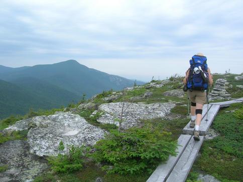
Join us on the Grafton Loop, a 38 mile backpack in the Grafton Notch State Park in Maine with 12,000 feet of total elevation gain. We will be covering 11 miles per day to complete the loop Thursday-Sunday, July 12-15.
Completed in 2001 the Loop is a relatively new trail which was created by a partnership of public and private organizations and if the first major new AMC project in the area since 1976. We will summit 6 peaks and cross a wide variety of terrain over four days and have great views from Old Speck [a 4,000 footer], Stowe, Long and the Baldpates Mountains!
There are plenty of steep, challenging sections on this route, which, combined with the backpack weight and equipment needs of an overnight trip, makes this a strenuous trip. We will maintain a steady hiking pace, stay together, and have ample rest breaks and take time to enjoy the magnificent views.
The backpack will begin where Rte. 26 meets the Appalachian Trail [AT] and we'll head south and climb up 2,760' elevation gain to Old Speck Mountain [4,170']. We'll then leave the AT and follow the Grafton Loop Trail [GLT] up to Sunday River Whitecap [3325'] and spend the night at Sargent Brook Camp. Total distance is 11.7 miles.
Day two we'll continue and find a spot to take a dip in a stream to cool off. After crossing Rte. 26 we'll climb to Puzzle Mountain [3142'] to enjoy the lovely vistas and set up our tents at the Stewart Campsite for the overnight. Total distance is 11.2 miles.
Day three is our easiest day where we'll have lunch at the Long Mountain viewpoint, find a swimming hole to take a dip and spend the night at East Baldpate Campsite. Total distance is 10.1 miles.
Day four we'll climb up to East Baldpate [3812'] and West Baldpate [3680'] with spectacular views. We'll meet up the Appalachian Trail once again to bring us back to our cars. We'll celebrate by having lunch at the Sunday River Brewing Company.
Click Here For Trail Map and Brochure
Lodging Option: Bunk beds are available at my house near Waterville Valley, NH for Wednesday night for $20 per night. Coffee/bagels each morning and linen/blankets/towels are provided. We have limited space in the fridge to store your beverages/food so it's best to bring a small cooler. Space is limited so email me ASAP to reserve a bunk!
Directions
The northern trailhead is located where the Appalachian Trail crosses Route 26 in Newry, Maine. From the junction of Route 2 and Route 26, travel North on Route 26 (towards Grafton Notch State Park) 13 miles from Bethel, Maine. There is large trailhead parking lot and we'll be driving a blue FJ Cruiser.
About this event
Join us on the Grafton Loop, a 38 mile backpack in the Grafton Notch State Park in Maine with 12,000 feet of total elevation gain. We will be covering 11 miles per day to complete the loop Thursday-Sunday, July 12-15.
Completed in 2001 the Loop is a relatively new trail which was created by a partnership of public and private organizations and if the first major new AMC project in the area since 1976. We will summit 6 peaks and cross a wide variety of terrain over four days and have great views from Old Speck [a 4,000 footer], Stowe, Long and the Baldpates Mountains!
There are plenty of steep, challenging sections on this route, which, combined with the backpack weight and equipment needs of an overnight trip, makes this a strenuous trip. We will maintain a steady hiking pace, stay together, and have ample rest breaks and take time to enjoy the magnificent views.
The backpack will begin where Rte. 26 meets the Appalachian Trail [AT] and we'll head south and climb up 2,760' elevation gain to Old Speck Mountain [4,170']. We'll then leave the AT and follow the Grafton Loop Trail [GLT] up to Sunday River Whitecap [3325'] and spend the night at Sargent Brook Camp. Total distance is 11.7 miles.
Day two we'll continue and find a spot to take a dip in a stream to cool off. After crossing Rte. 26 we'll climb to Puzzle Mountain [3142'] to enjoy the lovely vistas and set up our tents at the Stewart Campsite for the overnight. Total distance is 11.2 miles.
Day three is our easiest day where we'll have lunch at the Long Mountain viewpoint, find a swimming hole to take a dip and spend the night at East Baldpate Campsite. Total distance is 10.1 miles.
Day four we'll climb up to East Baldpate [3812'] and West Baldpate [3680'] with spectacular views. We'll meet up the Appalachian Trail once again to bring us back to our cars. We'll celebrate by having lunch at the Sunday River Brewing Company.
Click Here For Trail Map and Brochure
Lodging Option: Bunk beds are available at my house near Waterville Valley, NH for Wednesday night for $20 per night. Coffee/bagels each morning and linen/blankets/towels are provided. We have limited space in the fridge to store your beverages/food so it's best to bring a small cooler. Space is limited so email me ASAP to reserve a bunk!
Directions to the trailhead
Get directionsThe northern trailhead is located where the Appalachian Trail crosses Route 26 in Newry, Maine. From the junction of Route 2 and Route 26, travel North on Route 26 (towards Grafton Notch State Park) 13 miles from Bethel, Maine. There is large trailhead parking lot and we'll be driving a blue FJ Cruiser.
Who's going (2)

Questions about this event?
Reach out to the host, Gandalf, for route details, carpooling, or what to bring.
Email the hostYou can also ask in the event discussion below.
Event discussion
No comments yet.
Log in to join the conversation.