
Mt. Eisenhower Hike
<p>Our first hike of the summer...join us for Mt. Eisenhower!</p>
Mt. Eisenhower Hike
<p>Our first hike of the summer...join us for Mt. Eisenhower!</p>
Details
Our first hike of the summer...join us for Mt. Eisenhower! [Note: Please only sign up if you are sure you can go...we have had problems lately with members dropping out at the last minute after taking up a spot that someone else would have used. Thanks!]
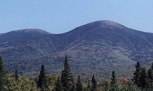
Mount Eisenhower is one of New Hampshire's 4000-footers and has only Mt. Monroe between it and Mt. Washington in the Presidential Range. It is the 12th highest of the NH 4000-footers at 4760 feet. It is a bald summit with 360 degree views of the southern Presidentials including Mt. Washington. This hike will follow the Edmand's Path for most of the hike with small stretches on the Mt. Eisenhower Loop trail and the Crawford Path [then return by Edmand's Path]. Most of the path is a very gradual climb but be aware that the final section [.2 miles] of the Edmand's Path and above are completely exposed the elements.
We will meet at the Edmand's Path trailhead on Mt. Clinton Road. Parking is $3.
Details:
What: Mount Eisenhower
Distance: 7.1 miles
Elevation Gain: 2750'
Pace: Moderate/Slow. Approximately 1.5 to 2.0 miles per hour.
Exposure: Fully exposed for the final .6 miles approaching the summit
Estimated Time: 6 hours including breaks
Is This Hike for Me?
This hike will be at a slow/moderate pace. We will make every attempt to keep the group together throughout the hike. The trail is never very steep and has good footing but is fully exposed approaching the summit.
To participate you should:
- Be comfortable hiking UPHILL at about 1.5 to 2.0 miles per hour at a 15% incline for about 4 miles.
- Be comfortable walking at least 8 miles on uneven terrain including roots, rocks, and granite ledges.
- Have sturdy hiking boots. No Sneakers!
- Have rain and wind protection. No Ponchos!
- Be able to carry at least 2-3 liters of water [3 strongly recommended]. [Remember, 1 liter weighs 2 pounds!]
- Be in good physical condition
Equipment List
- Synthetic shirt and pants. No cotton. No jeans.
- Sturdy hiking boots. No Sneakers.
- 2-3 liters of Water
- Headlamp
- Trail Snacks
- Lunch
Optional Gear:
- Hiking Poles
- Gaiters
- Sunscreen/Sunglasses
- Camera/Binoculars
No Jeans, Sneakers, or Cotton clothing on the hike!
After The Hike: Everyone is welcome back at our house in Waterville Valley to socialize around the deck and enjoy a home cooked meal with dessert! It's BYOB and it costs $5 per person.
Lodging Option: Bunk beds are available at my house near Waterville Valley, NH for Saturday night for $20 per night. Coffee/bagels each morning and linen/blankets/towels are provided. We have limited space in the fridge to store your beverages/food so it's best to bring a small cooler. Space is limited so email me ASAP to reserve a bunk!
Directions
From I-93 in NH, take exit 35 to Rt. 3 North to Twin Mountain. After about 10 miles [traffic light], turn right onto Rt. 302. Travel about 8 miles, then turn left onto Mt. Clinton Road. The entrance to Mt. Clinton Road is just below the AMC Highland Center, across Rt. 302. [If you reach or go past the AMC Highland Center on your right, turn around.] The Edmands Path trailhead and parking lot will be on your right, about 2.3 miles from Rt. 302.
About this event
Our first hike of the summer...join us for Mt. Eisenhower! [Note: Please only sign up if you are sure you can go...we have had problems lately with members dropping out at the last minute after taking up a spot that someone else would have used. Thanks!]
Mount Eisenhower is one of New Hampshire's 4000-footers and has only Mt. Monroe between it and Mt. Washington in the Presidential Range. It is the 12th highest of the NH 4000-footers at 4760 feet. It is a bald summit with 360 degree views of the southern Presidentials including Mt. Washington. This hike will follow the Edmand's Path for most of the hike with small stretches on the Mt. Eisenhower Loop trail and the Crawford Path [then return by Edmand's Path]. Most of the path is a very gradual climb but be aware that the final section [.2 miles] of the Edmand's Path and above are completely exposed the elements.
We will meet at the Edmand's Path trailhead on Mt. Clinton Road. Parking is $3.
Details:
What: Mount Eisenhower
Distance: 7.1 miles
Elevation Gain: 2750'
Pace: Moderate/Slow. Approximately 1.5 to 2.0 miles per hour.
Exposure: Fully exposed for the final .6 miles approaching the summit
Estimated Time: 6 hours including breaks
Is This Hike for Me?
This hike will be at a slow/moderate pace. We will make every attempt to keep the group together throughout the hike. The trail is never very steep and has good footing but is fully exposed approaching the summit.
To participate you should:
- Be comfortable hiking UPHILL at about 1.5 to 2.0 miles per hour at a 15% incline for about 4 miles.
- Be comfortable walking at least 8 miles on uneven terrain including roots, rocks, and granite ledges.
- Have sturdy hiking boots. No Sneakers!
- Have rain and wind protection. No Ponchos!
- Be able to carry at least 2-3 liters of water [3 strongly recommended]. [Remember, 1 liter weighs 2 pounds!]
- Be in good physical condition
Equipment List
- Synthetic shirt and pants. No cotton. No jeans.
- Sturdy hiking boots. No Sneakers.
- 2-3 liters of Water
- Headlamp
- Trail Snacks
- Lunch
Optional Gear:
- Hiking Poles
- Gaiters
- Sunscreen/Sunglasses
- Camera/Binoculars
No Jeans, Sneakers, or Cotton clothing on the hike!
After The Hike: Everyone is welcome back at our house in Waterville Valley to socialize around the deck and enjoy a home cooked meal with dessert! It's BYOB and it costs $5 per person.
Lodging Option: Bunk beds are available at my house near Waterville Valley, NH for Saturday night for $20 per night. Coffee/bagels each morning and linen/blankets/towels are provided. We have limited space in the fridge to store your beverages/food so it's best to bring a small cooler. Space is limited so email me ASAP to reserve a bunk!
Directions to the trailhead
Get directionsFrom I-93 in NH, take exit 35 to Rt. 3 North to Twin Mountain. After about 10 miles [traffic light], turn right onto Rt. 302. Travel about 8 miles, then turn left onto Mt. Clinton Road. The entrance to Mt. Clinton Road is just below the AMC Highland Center, across Rt. 302. [If you reach or go past the AMC Highland Center on your right, turn around.] The Edmands Path trailhead and parking lot will be on your right, about 2.3 miles from Rt. 302.
Who's going (7)
 SUSTAINING
 GUEST MEMBER
 GUEST MEMBER
 SUSTAINING
 GUEST MEMBER
 GUEST MEMBER
Questions about this event?
Reach out to the host, Gandalf, for route details, carpooling, or what to bring.
Email the hostYou can also ask in the event discussion below.
Event discussion
http://www.youtube.com/watch?v=vK7JD-XRMVk&list=HL1340625503&feature=mh_lolz
Log in to join the conversation.