
Mt. Greylock Loop Hike
<p>A loop hike around MA's highest peak from the Greylock Glen</p>
Mt. Greylock Loop Hike
<p>A loop hike around MA's highest peak from the Greylock Glen</p>
Details
Join me for this 6.5 - 7.0 mile loop hike to the summit of Mt. Greylock. This is Massachusetts' highest point at 3491 feet. Rising above the surrounding Berkshire landscape, dramatic views of 60-90 miles distant may be seen. It became Massachusetts' first wilderness state park, acquired by the Commonwealth in 1898.
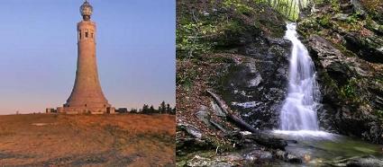
We will utilize the Bellows Pipe Trail on the ascent and return via the Gould Trail. Along the way on both trails there are dramatic waterfalls...in particular the Peck's Brook Falls with its three sections dropping approximately 72 feet. These will provide nice breaks to and from the summit. On the summit itself there are a collection of rustic CCC-built structures such as Bascom Lodge, as well as the 93-foot tall granite Massachusetts Veterans War Memorial Tower (all built in the 30's). There will be time to explore this open summit and this time of year, there should be no road traffic or crowds.
This is one of the more aggressive routes to the summit with about 2000 feet in elevation gain. Portions may be steep. While dogs are permitted in the park, this is probably not a dog-friendly hike.
Rain or harsh weather will postpone until Sunday, if appropriate.
What to Bring: Typical early spring hiking gear should be appropriate: convertible hiking pants, good sturdy hiking boots with thick socks, extra layer(s) and a windbreaker/raingear (just in case). Also bring along lunch, snacks and plenty of water. Optionally, pack bug repellent and sunscreen and anything else that you may require for a day hike.
Afterwards: We should be completed with the hike by 5PM. If there is sufficient interest, we'll cap the day off with dinner/drinks in Adams afterwards.
Directions
In Adams...just south of the intersection of Rts 8 (Commercial St) and 116 (Center St), turn west onto River Street. As the road crosses the river, this road will become Harmony Street and shortly thereafter will fork to the left as Fisk Street. Turn right onto West Road and very quickly turn left onto West Mountain Road. The Gould trailhead parking will be approximately 0.9 miles up this road. If you pass greenhouses, then you've gone too far. Look for a grey Hyundai Elantra. There is no fee for parking.
About this event
Join me for this 6.5 - 7.0 mile loop hike to the summit of Mt. Greylock. This is Massachusetts' highest point at 3491 feet. Rising above the surrounding Berkshire landscape, dramatic views of 60-90 miles distant may be seen. It became Massachusetts' first wilderness state park, acquired by the Commonwealth in 1898.
We will utilize the Bellows Pipe Trail on the ascent and return via the Gould Trail. Along the way on both trails there are dramatic waterfalls...in particular the Peck's Brook Falls with its three sections dropping approximately 72 feet. These will provide nice breaks to and from the summit. On the summit itself there are a collection of rustic CCC-built structures such as Bascom Lodge, as well as the 93-foot tall granite Massachusetts Veterans War Memorial Tower (all built in the 30's). There will be time to explore this open summit and this time of year, there should be no road traffic or crowds.
This is one of the more aggressive routes to the summit with about 2000 feet in elevation gain. Portions may be steep. While dogs are permitted in the park, this is probably not a dog-friendly hike.
Rain or harsh weather will postpone until Sunday, if appropriate.
What to Bring: Typical early spring hiking gear should be appropriate: convertible hiking pants, good sturdy hiking boots with thick socks, extra layer(s) and a windbreaker/raingear (just in case). Also bring along lunch, snacks and plenty of water. Optionally, pack bug repellent and sunscreen and anything else that you may require for a day hike.
Afterwards: We should be completed with the hike by 5PM. If there is sufficient interest, we'll cap the day off with dinner/drinks in Adams afterwards.
Directions to the trailhead
Get directionsIn Adams...just south of the intersection of Rts 8 (Commercial St) and 116 (Center St), turn west onto River Street. As the road crosses the river, this road will become Harmony Street and shortly thereafter will fork to the left as Fisk Street. Turn right onto West Road and very quickly turn left onto West Mountain Road. The Gould trailhead parking will be approximately 0.9 miles up this road. If you pass greenhouses, then you've gone too far. Look for a grey Hyundai Elantra. There is no fee for parking.
Who's going (3)
 GUEST MEMBER
 GUEST MEMBER
 SUSTAINING
Questions about this event?
Reach out to the host, shep5, for route details, carpooling, or what to bring.
Email the hostYou can also ask in the event discussion below.
Event discussion
No comments yet.
Log in to join the conversation.