
Welch-Dickey Hike
<p> Spring warm-up hike on the always popular Welch-Dickey loop trail.</p>
Welch-Dickey Hike
<p> Spring warm-up hike on the always popular Welch-Dickey loop trail.</p>
Details
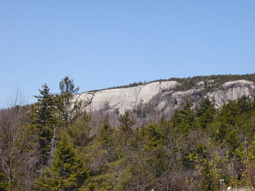
On the southern edge of NH's White Mountains, the Welch-Dickey trail is among the first to be clear of snow in the spring. It is also among the most popular trail in the Whites due to its relatively short length of 5 miles, and the spectacular views of the open ledges along most of the trail. Though technically below tree line (Mt. Dickey, the highest point is only 2,700 ft. high), it gets its Alpine ecology from the fact that the early English settlers used to burn the slopes in order to create pasture land for sheep. Given the unusually warm winter and spring we have been having here in New England, it is hard to predict the weather on this particular day, so bring warm layers to put on and take off as needed. If it is a nice warm day, we may linger at the "gay" lunch spot off the main trail, so bring a good lunch and snacks to share.
Inclement weather will cancel this event.
Directions
We will meet at the trailhead parking lot. Directions are as follows: Take I-93 exit 28 [Campton/Waterville Valley] and go east on Rt. 49, the Mad River Road. Approximately 4.5 miles after the intersection with Rt. 175 (the Campton dam & traffic light), turn left onto Upper Mad River road. In 0.7 mile turn right onto Orris Rd., there should be a Welch-Dickey hiker's sign there directing you to turn right, so you can't miss it. Drive another 0.6 mile to the parking lot on your right. I drive a gray Toyota Rav4, which is NOT a chick car...
About this event
On the southern edge of NH's White Mountains, the Welch-Dickey trail is among the first to be clear of snow in the spring. It is also among the most popular trail in the Whites due to its relatively short length of 5 miles, and the spectacular views of the open ledges along most of the trail. Though technically below tree line (Mt. Dickey, the highest point is only 2,700 ft. high), it gets its Alpine ecology from the fact that the early English settlers used to burn the slopes in order to create pasture land for sheep. Given the unusually warm winter and spring we have been having here in New England, it is hard to predict the weather on this particular day, so bring warm layers to put on and take off as needed. If it is a nice warm day, we may linger at the "gay" lunch spot off the main trail, so bring a good lunch and snacks to share.
Inclement weather will cancel this event.
Directions to the trailhead
Get directionsWe will meet at the trailhead parking lot. Directions are as follows: Take I-93 exit 28 [Campton/Waterville Valley] and go east on Rt. 49, the Mad River Road. Approximately 4.5 miles after the intersection with Rt. 175 (the Campton dam & traffic light), turn left onto Upper Mad River road. In 0.7 mile turn right onto Orris Rd., there should be a Welch-Dickey hiker's sign there directing you to turn right, so you can't miss it. Drive another 0.6 mile to the parking lot on your right. I drive a gray Toyota Rav4, which is NOT a chick car...
Who's going (7)
 SUSTAINING
 GUEST MEMBER
 SUSTAINING
 SUSTAINING
 SUSTAINING
 SUSTAINING
Questions about this event?
Reach out to the host, JPHiker, for route details, carpooling, or what to bring.
Email the hostYou can also ask in the event discussion below.
Event discussion
No comments yet.
Log in to join the conversation.