
South Moat Snowshoe
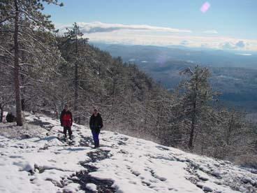
<p>A top-of-the-world feeling and unobstructed panaroma of peaks in every direction except north, where Middle and North Moat loom.</p>
South Moat Snowshoe
<p>A top-of-the-world feeling and unobstructed panaroma of peaks in every direction except north, where Middle and North Moat loom.</p>
Details
A top-of-the-world feeling and unobstructed panaroma of peaks in every direction except north, where Middle and North Moat loom.
A little under three hours from Boston, this bare cone [2770'] is almost as good a viewpoint as its higher ridgemate, North Moat.
Well-seen are the Presidentials, Carters, Evans Notch mountains, eastern Lakes Region, Sandwich Range, Hancock & Carrigain, and much more. It's south facing which means lots of sun!
Terrain: The first 1.5 miles is an easy, graded terrain. Then the trail becomes more steep and open with spectacular views east and west as we get within striking distance from the summit. You can reserve and rent snowshoes from your local outdoor outfitter such as REI, EMS, or from Ski Fanatics off Exit 28 on I-93.
Trail: This is an up and back hike using the relocated Moat Mountain trail until we reach the route of the original trail after 1.5 miles. The trail then becomes steep with rough footing where we pass an outlook to Mt. Chocorua. As we approach the summit we'll hike into beautiful red pines. [There will not be an official lunch stop. We'll be saving our appetite for the Moat Mountain Brewery].
Time/Distance: Hike time is approximately 4 hours. Round trip distance is 5.4 miles with 2,200 ft. elevation gain. We will take our time to enjoy the views, take pictures and have fun!
Gear List: Be sure to bring appropriate winter gear such as winter insulated boots, traction (micropikes, crampons, etc.), snowshoes (we have some to borrow so let us know), warm clothing (no cotton and blue jeans), water, lunch and snacks, etc.
After The Hike: Everyone is welcome back to join us in North Conway at the Moat Mountain Brewery. What better place to celebrate our adventure!
Lodging Option: Bunk beds are available at my house near Waterville Valley, NH for Saturday night for $20 per night. Coffee/bagels each morning and linen/blankets/towels are provided. We have limited space in the fridge to store your beverages/food so it's best to bring a small cooler. Space is limited so email me ASAP to reserve a bunk!
Carpooling: Contact other guys living near you for carpooling. If you are driving up I-93, meet Jon and I off the Exit 28 ramp at the Post Office parking lot for 11:30 A.M.
Directions
The southern terminus of the Moat Mountain Trailhead is located in Albany, New Hampshire, about 15 minutes northwest from Conway village.
From Rt. 16 in Conway:
- In Conway village, on Rt. 16, turn north onto Washington Street [traffic light] which is directly opposite the junction for Rt. 153 [a left-hand when traveling North; a right-hand turn when traveling south].
- After 0.2 mile, bear left onto West Side Road.
- Follow West Side for 0.7 mile, then bear left again [onto Still road].
- When that road ends after 0.6 mile, turn left onto Passaconaway Road which becomes Dugway Road.
- Travel 2.2 miles on Passaconaway Road, and then turn right into the Moat Mountain parking lot.
About this event
A top-of-the-world feeling and unobstructed panaroma of peaks in every direction except north, where Middle and North Moat loom.
A little under three hours from Boston, this bare cone [2770'] is almost as good a viewpoint as its higher ridgemate, North Moat.
Well-seen are the Presidentials, Carters, Evans Notch mountains, eastern Lakes Region, Sandwich Range, Hancock & Carrigain, and much more. It's south facing which means lots of sun!
Terrain: The first 1.5 miles is an easy, graded terrain. Then the trail becomes more steep and open with spectacular views east and west as we get within striking distance from the summit. You can reserve and rent snowshoes from your local outdoor outfitter such as REI, EMS, or from Ski Fanatics off Exit 28 on I-93.
Trail: This is an up and back hike using the relocated Moat Mountain trail until we reach the route of the original trail after 1.5 miles. The trail then becomes steep with rough footing where we pass an outlook to Mt. Chocorua. As we approach the summit we'll hike into beautiful red pines. [There will not be an official lunch stop. We'll be saving our appetite for the Moat Mountain Brewery].
Time/Distance: Hike time is approximately 4 hours. Round trip distance is 5.4 miles with 2,200 ft. elevation gain. We will take our time to enjoy the views, take pictures and have fun!
Gear List: Be sure to bring appropriate winter gear such as winter insulated boots, traction (micropikes, crampons, etc.), snowshoes (we have some to borrow so let us know), warm clothing (no cotton and blue jeans), water, lunch and snacks, etc.
After The Hike: Everyone is welcome back to join us in North Conway at the Moat Mountain Brewery. What better place to celebrate our adventure!
Lodging Option: Bunk beds are available at my house near Waterville Valley, NH for Saturday night for $20 per night. Coffee/bagels each morning and linen/blankets/towels are provided. We have limited space in the fridge to store your beverages/food so it's best to bring a small cooler. Space is limited so email me ASAP to reserve a bunk!
Carpooling: Contact other guys living near you for carpooling. If you are driving up I-93, meet Jon and I off the Exit 28 ramp at the Post Office parking lot for 11:30 A.M.
Directions to the trailhead
Get directionsThe southern terminus of the Moat Mountain Trailhead is located in Albany, New Hampshire, about 15 minutes northwest from Conway village.
From Rt. 16 in Conway:
- In Conway village, on Rt. 16, turn north onto Washington Street [traffic light] which is directly opposite the junction for Rt. 153 [a left-hand when traveling North; a right-hand turn when traveling south].
- After 0.2 mile, bear left onto West Side Road.
- Follow West Side for 0.7 mile, then bear left again [onto Still road].
- When that road ends after 0.6 mile, turn left onto Passaconaway Road which becomes Dugway Road.
- Travel 2.2 miles on Passaconaway Road, and then turn right into the Moat Mountain parking lot.
Who's going (6)



Questions about this event?
Reach out to the host, Gandalf, for route details, carpooling, or what to bring.
Email the hostYou can also ask in the event discussion below.
Event discussion
Luis
Log in to join the conversation.