
Detour Travel Gay Travel Tours
All events Share Moderate

Mt Crawford Snowshoe Hike

<p></p>

Mt Crawford Snowshoe Hike

<p></p>

Details

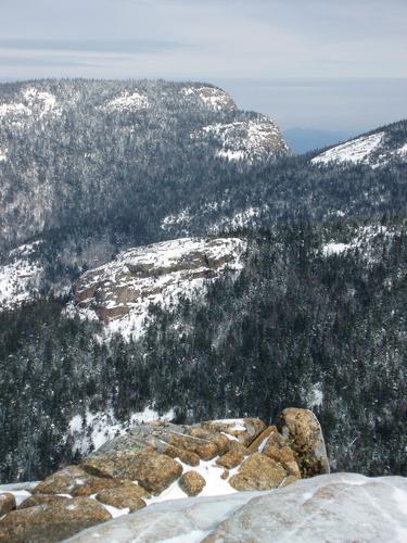
If you’re looking for a winter hike that offers a big mountain feel for a modest effort, this is your opportunity brotha! An ‘up and back’ trek with an elevation gain of 2100’, the 3,119-foot summit of Mount Crawford provides one of the most stunning vistas in the White Mountains, sort of like being up in a balloon enjoying an aerial view of the Presidentials, Frankenstein Cliff, Willey Range, and Mounts Carrigain and Tripyramid and is a relatively low peak just to the south of Crawford Notch. It is the first peak reached by hikers using the Davis Path, which makes a 15.0-mile ascent of Mount Washington through the Presidential Range–Dry River Wilderness Area. The hike up Mount Crawford begins along the banks of the Saco River, and climbs steadily to the summit, which has excellent 360-degree views. It is one of the oldest hiking trails in the White Mountains and provides a moderate to mildly strenuous ascent. The trail was completed by Nathaniel Davis in 1845 as a bridle path to the summit of Mount Washington. Davis was a son-in-law of Abel Crawford, the “Old Patriarch” of the Crawford family, who brought his family to the area in the 1790s. Abel built the Mount Crawford House near the current trailhead.  The trail fell into disuse in the 1850s and was brought back as a footpath in 1910 by the AMC. The total distance for the hike is 5 miles, alloting 5 hours to complete. This will give members ample time for viewing on the summit as well as casual breaks along the way.

What To Bring/Wear:  Be sure to bring appropriate winter gear such as winter insulated boots, additional/alternative traction (micropikes, crampons, etc.), snowshoes (I may have a pair to borrow if needed), warm clothing (dress in layers, cotton and blue jeans not recommended), water, lunch and snacks, etc.  After the hike we can gather for pub & grub in the Conway area if there is sufficient interest.

Directions

From the east take NH Rt 16N to Rt 302W and drive approx 12.7 miles. The Davis Path parking lot will be on your right. From the south or west, take I93N to exit 35 onto US Rt 3N toward Twin Mountain. Drive 10.3 miles to Rt 302E, then  drive approx 16.4 miles. The Davis Path parking lot will be on your left.
Sunday, March 4, 2012
Hart's Location (Bartlett), NH · Directions
Meet at 10:00 AM
Hosted by PineRiverPonder
5/12 signed up
Mt Crawford Snowshoe Hike

About this event

If you’re looking for a winter hike that offers a big mountain feel for a modest effort, this is your opportunity brotha! An ‘up and back’ trek with an elevation gain of 2100’, the 3,119-foot summit of Mount Crawford provides one of the most stunning vistas in the White Mountains, sort of like being up in a balloon enjoying an aerial view of the Presidentials, Frankenstein Cliff, Willey Range, and Mounts Carrigain and Tripyramid and is a relatively low peak just to the south of Crawford Notch. It is the first peak reached by hikers using the Davis Path, which makes a 15.0-mile ascent of Mount Washington through the Presidential Range–Dry River Wilderness Area. The hike up Mount Crawford begins along the banks of the Saco River, and climbs steadily to the summit, which has excellent 360-degree views. It is one of the oldest hiking trails in the White Mountains and provides a moderate to mildly strenuous ascent. The trail was completed by Nathaniel Davis in 1845 as a bridle path to the summit of Mount Washington. Davis was a son-in-law of Abel Crawford, the “Old Patriarch” of the Crawford family, who brought his family to the area in the 1790s. Abel built the Mount Crawford House near the current trailhead.  The trail fell into disuse in the 1850s and was brought back as a footpath in 1910 by the AMC. The total distance for the hike is 5 miles, alloting 5 hours to complete. This will give members ample time for viewing on the summit as well as casual breaks along the way.

What To Bring/Wear:  Be sure to bring appropriate winter gear such as winter insulated boots, additional/alternative traction (micropikes, crampons, etc.), snowshoes (I may have a pair to borrow if needed), warm clothing (dress in layers, cotton and blue jeans not recommended), water, lunch and snacks, etc.  After the hike we can gather for pub & grub in the Conway area if there is sufficient interest.

Directions to the trailhead

Get directions
Opens turn-by-turn directions to Hart's Location (Bartlett), NH, 03812 in Google Maps (new tab).

From the east take NH Rt 16N to Rt 302W and drive approx 12.7 miles. The Davis Path parking lot will be on your right. From the south or west, take I93N to exit 35 onto US Rt 3N toward Twin Mountain. Drive 10.3 miles to Rt 302E, then  drive approx 16.4 miles. The Davis Path parking lot will be on your left.

Who's going (5)

Vinnysca GUEST MEMBER
Vinnysca
Whitefield, NH
Attended
A member
Profile hidden
A member
Profile hidden
A member
Profile hidden
A member
Profile hidden

Questions about this event?

Questions for the host, PineRiverPonder, about route details, carpooling, or what to bring? Ask in the event discussion below.

Event discussion

Vinnysca · Mar 4, 2012
What a great hike with a group of awesome guys! Thanks, Kevin!
A member · Mar 4, 2012
Agreed! Great hike, good conditions. Smart move to reschedule. Nice job leading Kevin, thanks again.
-d
A member · Mar 5, 2012
Great hike, Kevin! I think the birds you spotted at the summit of Mt. Crawford were White-winged crossbills. They come south in winter when food is scarce up north and travel about erratically in search of Spruce cones. The male had a red head and body and both sexes have one or two distinctive white wingbars. Their spotting was a first for me so I was not sure what they were. We were lucky to see them. Great workout!

Log in to join the conversation.

Stay Connected with GayOutdoors

Receive outdoorsy tips, community updates, volunteer opportunities, event announcements, and trip reports.

We respect your privacy — unsubscribe anytime.