
Mt. Hedgehog Snowshoe Loop
<p></p>
Details
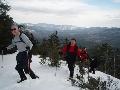
Summary: Located just north of Mt. Passaconaway in the Swift River Valley, Mt. Hedgehog separates the valley of the Oliverian Brook on its east from that of the Downes Brook on the west. The UNH Trail takes us to the summit of Mt. Hedgehog (2532') with a cumulative elevation gain of 1450' . The grade is moderate and only the final sections require a little extra effort. The advantage in taking the loop in a clockwise direction is to view the Presidential Range and Mt. Washington as we reach the summit from the south. Hedgehog is strikingly shaped with Allen's Ledge on the north, and the huge East ledges on Little Hedgehog. The vantage point from Allen's Ledge, which we'll visit on the way down after reaching the summit, affords remarkable views of Mt. Passaconaway, Mt. Chocorua, the Moats, the Presidential Range, the Carrigain Range, and many other eastern peaks. On a clear day even the observatory on top of Mt. Washington is visible. Although this is a popular trail and usually broken, snowshoes will be required. You can reserve and rent snowshoes from your local outdoor outfitter such as REI, EMS, etc. Total distance for this loop is 5 miles with 1,450 feet of elevation gain. It will take approximately 5 hours to complete allowing for a leisurely lunch at the summit or ledges and breaks.
What To Bring/Wear: Be sure to bring appropriate winter gear such as winter insulated boots, additional/alternative traction (micropikes, crampons, etc.), snowshoes (I may have a pair to borrow if needed), warm clothing (dress in layers, cotton and blue jeans not recommended), water, lunch and snacks, etc. After the hike we can gather for pub & grub in the Conway area if there is sufficient interest.
Directions
From the east, turn off NH Rt 16 in Conway onto Kancamagus Highway (NH 112) and drive about 14.3 miles. From the west on I-93, takeExit 32 in Lincoln and drive about 21.8 miles on the Kancamagus. You'll see a sign for the turn to the trailheads on the south side of the highway: the Downes Brook, UNH, and Mount Potash Trails. Turn here and drive in to the large parking area. I will be driving a green Honda Element.
About this event
Summary: Located just north of Mt. Passaconaway in the Swift River Valley, Mt. Hedgehog separates the valley of the Oliverian Brook on its east from that of the Downes Brook on the west. The UNH Trail takes us to the summit of Mt. Hedgehog (2532') with a cumulative elevation gain of 1450' . The grade is moderate and only the final sections require a little extra effort. The advantage in taking the loop in a clockwise direction is to view the Presidential Range and Mt. Washington as we reach the summit from the south. Hedgehog is strikingly shaped with Allen's Ledge on the north, and the huge East ledges on Little Hedgehog. The vantage point from Allen's Ledge, which we'll visit on the way down after reaching the summit, affords remarkable views of Mt. Passaconaway, Mt. Chocorua, the Moats, the Presidential Range, the Carrigain Range, and many other eastern peaks. On a clear day even the observatory on top of Mt. Washington is visible. Although this is a popular trail and usually broken, snowshoes will be required. You can reserve and rent snowshoes from your local outdoor outfitter such as REI, EMS, etc. Total distance for this loop is 5 miles with 1,450 feet of elevation gain. It will take approximately 5 hours to complete allowing for a leisurely lunch at the summit or ledges and breaks.
What To Bring/Wear: Be sure to bring appropriate winter gear such as winter insulated boots, additional/alternative traction (micropikes, crampons, etc.), snowshoes (I may have a pair to borrow if needed), warm clothing (dress in layers, cotton and blue jeans not recommended), water, lunch and snacks, etc. After the hike we can gather for pub & grub in the Conway area if there is sufficient interest.
Directions to the trailhead
Get directionsFrom the east, turn off NH Rt 16 in Conway onto Kancamagus Highway (NH 112) and drive about 14.3 miles. From the west on I-93, takeExit 32 in Lincoln and drive about 21.8 miles on the Kancamagus. You'll see a sign for the turn to the trailheads on the south side of the highway: the Downes Brook, UNH, and Mount Potash Trails. Turn here and drive in to the large parking area. I will be driving a green Honda Element.
Who's going (3)


Questions about this event?
Questions for the host, PineRiverPonder, about route details, carpooling, or what to bring? Ask in the event discussion below.
Event discussion
Log in to join the conversation.