
Tully Trail East
<p>Join me on this 11 mile hike, with excellent views, and numerous elaborate waterfalls!</p>
Tully Trail East
<p>Join me on this 11 mile hike, with excellent views, and numerous elaborate waterfalls!</p>
Details
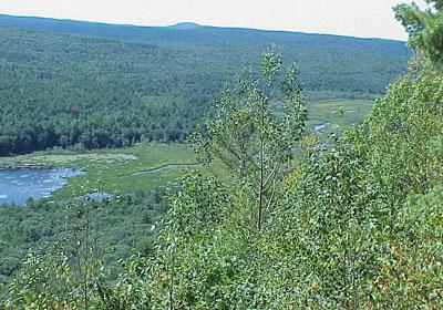
Come join me as I hike the Eastern side of the Tully Trail. This hike will bring us along numerous elaborate waterfalls, including Royalston Falls, Spirit Falls, and Doanes Falls. We will also get to see the scenic views from the ledges, Tully lake, and the Royalston Falls shelter. This will be an 11 mile hike, taking roughly 6 hours, and is rated as moderate to strenuous. The terrain will be fairly easy, follwing the rolling hills of Central MA, with a few climbs/descents of several hundred feet at a time.
This trail is in the Tully Lake conservation area, which was built by the U.S. Army Corps of Engineers in 1949. This section of trail follows a small riverbed which feeds Tully Lake from the North. Along this trail, there are signs of old farms, with occasional rusty farm equipment and vehicles left for decades.
This will be a one-way hike with spotted cars (I will pre arrange with one person on the hike). Please dress warmly, as this is a 6 hour hike in January. I also suggest you bring plenty of water and food as there are no stores nearby. Rain will cancel this event, snow will not unless it is enough to make the roads unsafe. Microspikes may be needed if there is ice/snow on the trails by January 8th, but I will advise as the time gets closer based upon weather conditions.
We will be doing an 11 mile section of the 22 mile Tully Trail loop. I am very familiar with this area and have hiked the entire trail, as well as different sections many times.
We may go out to seat somewhere locally afterwards if there is sufficient interest.
Directions
The hike will begin at the DCR Royalston Falls Parking lot, and end at the DCR Doanes Falls Parking Lot. I will pre arrange with someone on the hike to have a car parked at Doanes Falls to shuttle us back to Royalston Falls.
Directions to DCR Royalston Falls;
From Rt 2 in Mass, take exit 18, Rt 2A, follow West into Athol. At the intersection of Rts 2A/32 in Athol, cross Millers River bridge and bear right onto Chestnut Hill Rd. (Becomes Athol Rd) North towards Royalston. From Royalston Center, follow Rt. 68 North until it ends. Then follow Rt 32 North for 1.7 Miles until you see the Royalston Falls DCR entrance on the right.
(Please beware, sign bandits took some of the Rt 68 and Rt 32 signs, but you can still easily find your way)
From NH and VT, take Rt 119 to Richmond NH general store and 4 corners. Take Rt. 32 South, and look for the Royalston Falls DCR entrance on your left, less than 5 minutes after passing the MA/NH State line.
About this event
Come join me as I hike the Eastern side of the Tully Trail. This hike will bring us along numerous elaborate waterfalls, including Royalston Falls, Spirit Falls, and Doanes Falls. We will also get to see the scenic views from the ledges, Tully lake, and the Royalston Falls shelter. This will be an 11 mile hike, taking roughly 6 hours, and is rated as moderate to strenuous. The terrain will be fairly easy, follwing the rolling hills of Central MA, with a few climbs/descents of several hundred feet at a time.
This trail is in the Tully Lake conservation area, which was built by the U.S. Army Corps of Engineers in 1949. This section of trail follows a small riverbed which feeds Tully Lake from the North. Along this trail, there are signs of old farms, with occasional rusty farm equipment and vehicles left for decades.
This will be a one-way hike with spotted cars (I will pre arrange with one person on the hike). Please dress warmly, as this is a 6 hour hike in January. I also suggest you bring plenty of water and food as there are no stores nearby. Rain will cancel this event, snow will not unless it is enough to make the roads unsafe. Microspikes may be needed if there is ice/snow on the trails by January 8th, but I will advise as the time gets closer based upon weather conditions.
We will be doing an 11 mile section of the 22 mile Tully Trail loop. I am very familiar with this area and have hiked the entire trail, as well as different sections many times.
We may go out to seat somewhere locally afterwards if there is sufficient interest.
Directions to the trailhead
Get directionsThe hike will begin at the DCR Royalston Falls Parking lot, and end at the DCR Doanes Falls Parking Lot. I will pre arrange with someone on the hike to have a car parked at Doanes Falls to shuttle us back to Royalston Falls.
Directions to DCR Royalston Falls;
From Rt 2 in Mass, take exit 18, Rt 2A, follow West into Athol. At the intersection of Rts 2A/32 in Athol, cross Millers River bridge and bear right onto Chestnut Hill Rd. (Becomes Athol Rd) North towards Royalston. From Royalston Center, follow Rt. 68 North until it ends. Then follow Rt 32 North for 1.7 Miles until you see the Royalston Falls DCR entrance on the right.
(Please beware, sign bandits took some of the Rt 68 and Rt 32 signs, but you can still easily find your way)
From NH and VT, take Rt 119 to Richmond NH general store and 4 corners. Take Rt. 32 South, and look for the Royalston Falls DCR entrance on your left, less than 5 minutes after passing the MA/NH State line.
Who's going (2)


Questions about this event?
Questions for the host, outdoorsyguy79, about route details, carpooling, or what to bring? Ask in the event discussion below.
Event discussion
No comments yet.
Log in to join the conversation.