
Iron Mountain Hike
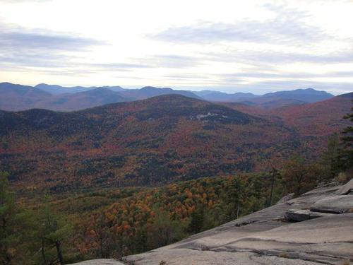
<p>This small mountain, reached by the Iron Mountain Trail, has a fine north outlook and a broad ledge with an excellent view on its south end.</p>
Iron Mountain Hike
<p>This small mountain, reached by the Iron Mountain Trail, has a fine north outlook and a broad ledge with an excellent view on its south end.</p>
Details
The hike is 6 miles with 1,400 feet elevation gain. The Forest Service Road will be closed so we'll first hike 1.2 miles to reach the actual trailhead that will give us extraordinary views of the snowcapped Presidentials and Mount Washington in particular.
Moving on we'll see evidence of an old ski slope and then have to deal with a steep and very difficult climb due to trail erosion. The payback is reaching the northern viewpoint for lunch! The summit is wooded but has evidence of the former firetower. We'll move on to the southern cliffs with breathtaking panaromic views. We'll then check out the remains of the iron mines and then return the way we came.
Please bring at least 2 liters of water, lunch, snacks and dress in layers. No cotton!
Bring a change of clothes because after the hike we'll have dinner at the Red Fox Pub in Jackson, NH.
Lodging Option: I have 8 bunks available with linen for Saturday night at my house in Waterville Valley for $20. You can use the kitchen facilities and store beverages/food in the fridge. I serve coffee in the morning and a continental breakfast. Contact me to RSVP. SPACE IS LIMITED TO EIGHT GUYS.
Directions
The trailhead for Iron Mountain is located in Jackson, New Hampshire.
From the South:
- From the junction of Routes 16 and 302 in Glen, turn north onto Rt. 16.
- Travel about 2.7 miles, then turn left onto Green Hill Road. This is 0.2 north of the red covered bridge in Jackson.
- Follow Green Hill Road for 1.4 miles [pavement ends at 1.2 miles] which will bring you to a fork on the road. Park here. We'll be driving a blue Toyota FJ Cruiser.
From the North:
- From the junction of Routes 16 and 2 in Gorham, turn south onto Rt. 16.
- Travel for about 20 miles, then turn right onto Green Hill Road. If you reach the red covered bridge in Jackson, you have gone 0.2 miles too far.
- Follow Green Hill Road for 1.4 miles [pavement ends at 1.2 miles] which will bring you to a fork on the road. Park here. We'll be driving a blue Toyota FJ Cruiser.
About this event
The hike is 6 miles with 1,400 feet elevation gain. The Forest Service Road will be closed so we'll first hike 1.2 miles to reach the actual trailhead that will give us extraordinary views of the snowcapped Presidentials and Mount Washington in particular.
Moving on we'll see evidence of an old ski slope and then have to deal with a steep and very difficult climb due to trail erosion. The payback is reaching the northern viewpoint for lunch! The summit is wooded but has evidence of the former firetower. We'll move on to the southern cliffs with breathtaking panaromic views. We'll then check out the remains of the iron mines and then return the way we came.
Please bring at least 2 liters of water, lunch, snacks and dress in layers. No cotton!
Bring a change of clothes because after the hike we'll have dinner at the Red Fox Pub in Jackson, NH.
Lodging Option: I have 8 bunks available with linen for Saturday night at my house in Waterville Valley for $20. You can use the kitchen facilities and store beverages/food in the fridge. I serve coffee in the morning and a continental breakfast. Contact me to RSVP. SPACE IS LIMITED TO EIGHT GUYS.
Directions to the trailhead
Get directionsThe trailhead for Iron Mountain is located in Jackson, New Hampshire.
From the South:
- From the junction of Routes 16 and 302 in Glen, turn north onto Rt. 16.
- Travel about 2.7 miles, then turn left onto Green Hill Road. This is 0.2 north of the red covered bridge in Jackson.
- Follow Green Hill Road for 1.4 miles [pavement ends at 1.2 miles] which will bring you to a fork on the road. Park here. We'll be driving a blue Toyota FJ Cruiser.
From the North:
- From the junction of Routes 16 and 2 in Gorham, turn south onto Rt. 16.
- Travel for about 20 miles, then turn right onto Green Hill Road. If you reach the red covered bridge in Jackson, you have gone 0.2 miles too far.
- Follow Green Hill Road for 1.4 miles [pavement ends at 1.2 miles] which will bring you to a fork on the road. Park here. We'll be driving a blue Toyota FJ Cruiser.
Who's going (3)


Questions about this event?
Reach out to the host, Gandalf, for route details, carpooling, or what to bring.
Email the hostYou can also ask in the event discussion below.
Event discussion
Log in to join the conversation.