
Mt. Madison [5366'] & Mt. Adams [5717']
<p>The second and fifth highest peaks in New England and part of the spectacular Presidential Range!</p>
Mt. Madison [5366'] & Mt. Adams [5717']
<p>The second and fifth highest peaks in New England and part of the spectacular Presidential Range!</p>
Details
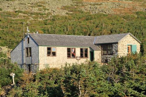
We will hike up the Air Line to do Adams. Then we will go to Madison and also check out the brand new Madison Hut. We will return via the Valley Way back to the trailhead.
THIS IS AN ADVANCE HIKE and you should be in great hiking shape to attend. Everyone must have an outdoor fitness level of Strenuous or higher to attend and your profile under Events Participated should indicate you've hiked more difficult 4,000 footers in the past. If you are a fast hiker and don't like to stick with the group either up or down, then please do not sign up. GROUP SAFETY IS OUR MOST IMPORTANT CONCERN.
Mount Adams
This is the second highest peak in the White Mountains of New Hampshire, and the one with the greatest elevation gain by any of the standard routes. Air Line is the shortest route to Adams, and provides maximum views with its traverse of the exposed "Knife Edge" on upper Durand Ridge; the looks into King Ravine are especially dramatic. I put the words "Knife Edge" in quotes, it's wider than the description suggests, and the views great. Significant boulder scrambling is required on both summit cones, but you will enjoy some of the most magnificent mountain views in the northeastern United States. Trail surface is hard-packed dirt and rock below treeline; boulder-strewn above. If you have any questions contact either Mike or Jon. Look forward to seeing many of the stronger gay hikers. We will have a blast!
Mount Madison
Elevation 5,366 feet is the fifth-highest peak in New England and part of the spectacular Presidential Range. We'll be descending on the Valley Way Trail, which is the easiest way to descend and also the most sheltered.
Type: Loop
Duration: 8.5 hours
Elevation Gain: 5050 feet
Mileage: 10 miles
After The Hike: We'll have a BBQ back on my deck at my house in Waterville Valley. It's BYOB and about $5 per person for food costs. Bring a change of clothes. I have lots of towels and everyone can take showers to clean up.
Lodging Option: I have 8 bunks available with linen for Friday and/or Saturday night at my house in Waterville Valley for $20. You can use the kitchen facilities and store beverages/food in the fridge. I serve coffee in the morning and a continental breakfast. Contact me to RSVP. SPACE IS LIMITED TO EIGHT GUYS.
Directions
We will be starting at Appalachia from US 2. The large parking area at Appalachia is one of the major trailheads in the Whites. It's located on the left side of US 2, 5.5 miles from the NH 16/US 2 junction in Gorham; or on the right ride of US 2, 2 miles from Lowe's Store in Randolph. If you need additional directions, please contact us.
About this event
We will hike up the Air Line to do Adams. Then we will go to Madison and also check out the brand new Madison Hut. We will return via the Valley Way back to the trailhead.
THIS IS AN ADVANCE HIKE and you should be in great hiking shape to attend. Everyone must have an outdoor fitness level of Strenuous or higher to attend and your profile under Events Participated should indicate you've hiked more difficult 4,000 footers in the past. If you are a fast hiker and don't like to stick with the group either up or down, then please do not sign up. GROUP SAFETY IS OUR MOST IMPORTANT CONCERN.
Mount Adams
This is the second highest peak in the White Mountains of New Hampshire, and the one with the greatest elevation gain by any of the standard routes. Air Line is the shortest route to Adams, and provides maximum views with its traverse of the exposed "Knife Edge" on upper Durand Ridge; the looks into King Ravine are especially dramatic. I put the words "Knife Edge" in quotes, it's wider than the description suggests, and the views great. Significant boulder scrambling is required on both summit cones, but you will enjoy some of the most magnificent mountain views in the northeastern United States. Trail surface is hard-packed dirt and rock below treeline; boulder-strewn above. If you have any questions contact either Mike or Jon. Look forward to seeing many of the stronger gay hikers. We will have a blast!
Mount Madison
Elevation 5,366 feet is the fifth-highest peak in New England and part of the spectacular Presidential Range. We'll be descending on the Valley Way Trail, which is the easiest way to descend and also the most sheltered.
Type: Loop
Duration: 8.5 hours
Elevation Gain: 5050 feet
Mileage: 10 miles
After The Hike: We'll have a BBQ back on my deck at my house in Waterville Valley. It's BYOB and about $5 per person for food costs. Bring a change of clothes. I have lots of towels and everyone can take showers to clean up.
Lodging Option: I have 8 bunks available with linen for Friday and/or Saturday night at my house in Waterville Valley for $20. You can use the kitchen facilities and store beverages/food in the fridge. I serve coffee in the morning and a continental breakfast. Contact me to RSVP. SPACE IS LIMITED TO EIGHT GUYS.
Directions to the trailhead
Get directionsWe will be starting at Appalachia from US 2. The large parking area at Appalachia is one of the major trailheads in the Whites. It's located on the left side of US 2, 5.5 miles from the NH 16/US 2 junction in Gorham; or on the right ride of US 2, 2 miles from Lowe's Store in Randolph. If you need additional directions, please contact us.
Who's going (4)

Questions about this event?
Reach out to the host, Gandalf, for route details, carpooling, or what to bring.
Email the hostYou can also ask in the event discussion below.
Event discussion
Log in to join the conversation.