
Mt. Moosilauke Hike
<p>Hike the westernmost of NH's four thousand footers.</p>
Mt. Moosilauke Hike
<p>Hike the westernmost of NH's four thousand footers.</p>
Details
Mt. Moosilauke is one of my favorite summer time hikes, and what better way to enjoy it than by going up the Beaver Brook Trail section of the Appalachian Trail. This is one of the shortest (3.8 miles) but steepest trails up to the summit. It borders a series of waterfalls, where the trail is rocky, wet, and steep. The Dartmouth Outing Club maintains this trail, and their volunteers have placed numerous re-bar handholds, and other assorted footholds to help in the ascent. Nevertheless, I do not recommend this hike if you have difficulties hiking up this type of tough terrain. We will come down the Benton Trail, which is a moderate 3.6 mile descent. The total mileage will be 7.4 miles.
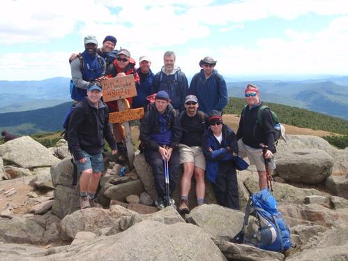
Since we need to spot cars, it's imperative that you adhere to the 8:30 a.m. meeting time, as it will take us approximately 20 to 30 minutes to spot cars at the Benton Trailhead. Also, the summit of this mountain is very exposed, windy, and chilly, even in summer, so bring a good weatherproof parka and pants to carry in your pack to use as needed. A case in point, that photo below of the group at the summit was taken in mid-August of last year. Also, note that there is no potable water on this trail, so bring sufficient water for yourself. Bring snacks and a good lunch to have at the top.
Directions
We will meet at the Beaver Brook Trailhead on NH 112 at Kinsman Notch. From I-93 take exit 32 (Rt. 112 Lincoln/Woodstock) and go west to Woodstock. After you cross the town's traffic light, stay on Rt. 112 west, which is now called the Lost River Road. Go for approximately 6 miles and you will see a trailhead parking lot on your left. This is a WMNF parking area so you need to either have a yearly pass or a pay-per-day parking slip which you can purchase there (on the honor system). Rain will cancel.
About this event
Mt. Moosilauke is one of my favorite summer time hikes, and what better way to enjoy it than by going up the Beaver Brook Trail section of the Appalachian Trail. This is one of the shortest (3.8 miles) but steepest trails up to the summit. It borders a series of waterfalls, where the trail is rocky, wet, and steep. The Dartmouth Outing Club maintains this trail, and their volunteers have placed numerous re-bar handholds, and other assorted footholds to help in the ascent. Nevertheless, I do not recommend this hike if you have difficulties hiking up this type of tough terrain. We will come down the Benton Trail, which is a moderate 3.6 mile descent. The total mileage will be 7.4 miles.
Since we need to spot cars, it's imperative that you adhere to the 8:30 a.m. meeting time, as it will take us approximately 20 to 30 minutes to spot cars at the Benton Trailhead. Also, the summit of this mountain is very exposed, windy, and chilly, even in summer, so bring a good weatherproof parka and pants to carry in your pack to use as needed. A case in point, that photo below of the group at the summit was taken in mid-August of last year. Also, note that there is no potable water on this trail, so bring sufficient water for yourself. Bring snacks and a good lunch to have at the top.
Directions to the trailhead
Get directionsWe will meet at the Beaver Brook Trailhead on NH 112 at Kinsman Notch. From I-93 take exit 32 (Rt. 112 Lincoln/Woodstock) and go west to Woodstock. After you cross the town's traffic light, stay on Rt. 112 west, which is now called the Lost River Road. Go for approximately 6 miles and you will see a trailhead parking lot on your left. This is a WMNF parking area so you need to either have a yearly pass or a pay-per-day parking slip which you can purchase there (on the honor system). Rain will cancel.
Who's going (6)
 SUSTAINING
 SUSTAINING
 GUEST MEMBER
 SUSTAINING
Questions about this event?
Reach out to the host, JPHiker, for route details, carpooling, or what to bring.
Email the hostYou can also ask in the event discussion below.
Event discussion
No comments yet.
Log in to join the conversation.