
Mt. Washington via Ammonoosuc ravine
<p> Hike up to Mt. Washington via the Ammonoosuc ravine</p>
Mt. Washington via Ammonoosuc ravine
<p> Hike up to Mt. Washington via the Ammonoosuc ravine</p>
Details
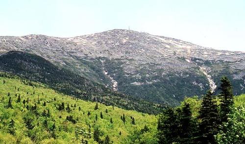
We will be taking the Ammonoosuc ravine trail up from the cog railway depot and via the Lake of the Clouds Hut. The ascent is generally a moderate one, except for the few hundred feet right below the AMC hut where it gets very steep. From there to the summit is also fairly steep, with the added pleasure that now we will be above treeline and very exposed. The total ascent from the base up to the summit is 4,100 feet, so this is quite a hike up to the top of New England's highest peak. We will descend via the Jewell Trail back down to the cog railway depot. At some point below the summit, the trail will take us under the cog railway tracks, which by are now are generally free of coal residue (the cog railway engines are now diesel powered). The total mileage is 9.6 miles, and a good chunk of this hike will be above treeline in fairly exposed terrain where bad weather is always likely to kick-in unannounced. So come prepared. Wear no cotton, and bring a good weatherproof parka and pants to carry in your pack in case you need them. Also bring plenty of water. There will be water at the AMC hut and at the summit house, but in between you'll have to drink what you carry. Also bring plenty of snacks and a good lunch. Rain and/or threat of thunderstorms will cancel this event.
Directions
We will meet at the hiker's parking lot at the Base Road approach to the cog railway depot. This road is best accessed from Route 302 (about 10 miles north of Crawford Notch; or 4 miles south of where 302 intersects Rt. 3 in Twin Mountain). Base Road is well marked. You will see a restaurant called Fabyan's on 302, and a big sign telling you to turn onto Base Road for the cog railway. Go about 6 miles on Base Road till it dead ends at the cog railway. The hiker's parking lot is a few hundred feet, on the right, before the entrance to the railway depot's parking lot. You can also park at the depot's parking lot, but they will charge you if you are a hiker and not a cog railway customer. The hiker's parking lot is free if you have a WMNF parking sticker.
About this event
We will be taking the Ammonoosuc ravine trail up from the cog railway depot and via the Lake of the Clouds Hut. The ascent is generally a moderate one, except for the few hundred feet right below the AMC hut where it gets very steep. From there to the summit is also fairly steep, with the added pleasure that now we will be above treeline and very exposed. The total ascent from the base up to the summit is 4,100 feet, so this is quite a hike up to the top of New England's highest peak. We will descend via the Jewell Trail back down to the cog railway depot. At some point below the summit, the trail will take us under the cog railway tracks, which by are now are generally free of coal residue (the cog railway engines are now diesel powered). The total mileage is 9.6 miles, and a good chunk of this hike will be above treeline in fairly exposed terrain where bad weather is always likely to kick-in unannounced. So come prepared. Wear no cotton, and bring a good weatherproof parka and pants to carry in your pack in case you need them. Also bring plenty of water. There will be water at the AMC hut and at the summit house, but in between you'll have to drink what you carry. Also bring plenty of snacks and a good lunch. Rain and/or threat of thunderstorms will cancel this event.
Directions to the trailhead
Get directionsWe will meet at the hiker's parking lot at the Base Road approach to the cog railway depot. This road is best accessed from Route 302 (about 10 miles north of Crawford Notch; or 4 miles south of where 302 intersects Rt. 3 in Twin Mountain). Base Road is well marked. You will see a restaurant called Fabyan's on 302, and a big sign telling you to turn onto Base Road for the cog railway. Go about 6 miles on Base Road till it dead ends at the cog railway. The hiker's parking lot is a few hundred feet, on the right, before the entrance to the railway depot's parking lot. You can also park at the depot's parking lot, but they will charge you if you are a hiker and not a cog railway customer. The hiker's parking lot is free if you have a WMNF parking sticker.
Who's going (4)
 SUSTAINING
 GUEST MEMBER
 GUEST MEMBER
Questions about this event?
Reach out to the host, JPHiker, for route details, carpooling, or what to bring.
Email the hostYou can also ask in the event discussion below.
Event discussion
No comments yet.
Log in to join the conversation.