
Mt. Jefferson/Clay
<p>Mt. Jefferson at 5,716 ft. is an enjoyable hike if the weather cooperates.</p>
Mt. Jefferson/Clay
<p>Mt. Jefferson at 5,716 ft. is an enjoyable hike if the weather cooperates.</p>
Details
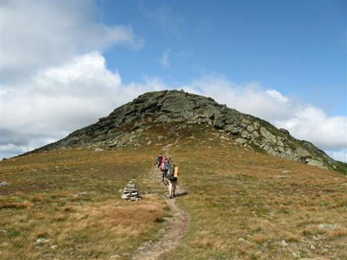
Mt. Jefferson at 5,716 ft is an enjoyable hike if the weather cooperates. I particularly enjoy Monticello Lawn as it slopes away into the Great Gulf and Jefferson Ravine. The views across the Great Gulf Wilderness to the Carter Range are especially beautiful.
Distance: 11.2 round trip
Elevation Gain; 3,216 ft.
Estimated Time: 8-10 hours
We will meet in front of the Cog Railway Visitor's Center [Marshfield Station] and take the Jewell Trail to the Gulfside Trail, a distance of 3.7 miles. Jewell reaches treeline in about 3 miles and from then on we will be fully exposed to the prevailing westerly winds. Once we reach the Gulfside trail we will first head to Mt. Clay for lunch [much quieter] and then continue towards Jefferson with its numerous false summits before reaching the main summit.
Travel above treeline offers unique challenges to any hiker. Please have the appropriate gear/clothing to travel above treeline [rain shell] and the appropriate amount of layers to keep your core body warm.
Book time is approximately 8-10 hours round trip if the conditions are good. One caveat, visibility has to be good! Hiking in zero or low visibility on the ridge to Jefferson is not wise, especially given that the cairns are not very large. Jewell is realistically our only escape route if the weather changes drastically, so if the conditions worsen to where our visibility becomes an issue, we will cancel the hike and we will head down immediately!!
This hike is contingent upon the weather. Wind speed and visibility are the two main variables that can cancel this hike; besides rain.
After The Hike: We'll have a BBQ back on my deck at my house in Waterville Valley. It's BYOB and about $5 per person for food costs. Bring a change of clothes. I have lots of towels and everyone can take showers to clean up.
Lodging Option: I have 8 bunks available with linen for Friday and/or Saturday night at my house in Waterville Valley for $20. You can use the kitchen facilities and store beverages/food in the fridge. I serve coffee in the morning and a continental breakfast. Contact me to RSVP. SPACE IS LIMITED TO EIGHT GUYS.
Directions
I-93 to Rt. 3 to 302. Turn right on 302 and head east. Turn left onto the Cog Railway Base Road and park at the lower parking areas below Marshfield Station [there is a parking fee]. Do not park at the official White Mountain National Forest trailhead.
About this event
Mt. Jefferson at 5,716 ft is an enjoyable hike if the weather cooperates. I particularly enjoy Monticello Lawn as it slopes away into the Great Gulf and Jefferson Ravine. The views across the Great Gulf Wilderness to the Carter Range are especially beautiful.
Distance: 11.2 round trip
Elevation Gain; 3,216 ft.
Estimated Time: 8-10 hours
We will meet in front of the Cog Railway Visitor's Center [Marshfield Station] and take the Jewell Trail to the Gulfside Trail, a distance of 3.7 miles. Jewell reaches treeline in about 3 miles and from then on we will be fully exposed to the prevailing westerly winds. Once we reach the Gulfside trail we will first head to Mt. Clay for lunch [much quieter] and then continue towards Jefferson with its numerous false summits before reaching the main summit.
Travel above treeline offers unique challenges to any hiker. Please have the appropriate gear/clothing to travel above treeline [rain shell] and the appropriate amount of layers to keep your core body warm.
Book time is approximately 8-10 hours round trip if the conditions are good. One caveat, visibility has to be good! Hiking in zero or low visibility on the ridge to Jefferson is not wise, especially given that the cairns are not very large. Jewell is realistically our only escape route if the weather changes drastically, so if the conditions worsen to where our visibility becomes an issue, we will cancel the hike and we will head down immediately!!
This hike is contingent upon the weather. Wind speed and visibility are the two main variables that can cancel this hike; besides rain.
After The Hike: We'll have a BBQ back on my deck at my house in Waterville Valley. It's BYOB and about $5 per person for food costs. Bring a change of clothes. I have lots of towels and everyone can take showers to clean up.
Lodging Option: I have 8 bunks available with linen for Friday and/or Saturday night at my house in Waterville Valley for $20. You can use the kitchen facilities and store beverages/food in the fridge. I serve coffee in the morning and a continental breakfast. Contact me to RSVP. SPACE IS LIMITED TO EIGHT GUYS.
Directions to the trailhead
Get directionsI-93 to Rt. 3 to 302. Turn right on 302 and head east. Turn left onto the Cog Railway Base Road and park at the lower parking areas below Marshfield Station [there is a parking fee]. Do not park at the official White Mountain National Forest trailhead.
Who's going (4)
 SUSTAINING
 SUSTAINING
 GUEST MEMBER
Questions about this event?
Reach out to the host, Gandalf, for route details, carpooling, or what to bring.
Email the hostYou can also ask in the event discussion below.
Event discussion
Log in to join the conversation.