
The Twins/Galehead Hike
<p>The Twins are two lofty peaks that rise above the Pemigewasset Wilderness, offering spectacular views.</p>
The Twins/Galehead Hike
<p>The Twins are two lofty peaks that rise above the Pemigewasset Wilderness, offering spectacular views.</p>
Details
The twins are two lofty peaks that rise above the Pemigewasset Wilderness, offering spectacular views.
If you like a good challenge and beautiful views, then this hike is for you. The Twin Peaks are two of the highest peaks in the Twin Range, which is the loftiest ridge between the Presidentials and the Franconia's. On a clear day, you will experience outstanding views of the Pemigewasset Wilderness and surrounding mountains.
If you are peak bagging, this hike will gain you three summits on you NH4K list.
Totals:
Round Trip [all 2 peaks]: 12 miles
Book Time: 9 hr 41 min [If we move quickly enough, we should finish by 6PM]
Elevation Gain: 3932
Please Note That All Participants Will Be Screened:
This is considered a strenuous hike. There is one stream crossing that may be difficult in high water. There are steep sections and boulder scrambles. You will need to have previous experience hiking in higher elevations [we'll check your profile under events participated], your profile outdoor fitness level must at least indicate 'moderate to strenuous], and you should be able to hike at a moderate to fast pace. Anyone we are unsure of will be emailed for further questioning.
Excursion Details
This is a Traverse Hike requiring car spotting. We will meet at 8:00AM at the Gale River Trailhead to spot cars. After leaving some cars here, we will then drive to North Twin Trailhead to begin our hike.
Our hike will begin at the North Twin Trailhead.
We will bypass the first two stream crossings using a herd path but the third one can be difficult in high water. You may want to bring trekking poles and spare socks in case your boots get wet.
We will continue along the trail to the Summit of North Twin Mtn. [4761']. There is a beautiful outlook with magnificent views just before the true summit so be sure to bring your camera!
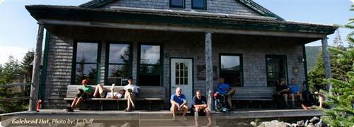
After bagging North Twin, we will continue on the North Twin Spur to the summit of South Twin which is a boulder and rocky peak [4902']. If the weather cooperates, we will enjoy lunch on the South Twin summit. If the weather is not suitable for a longer break here, we will eat at the Galehead Hut.
After summiting South Twin we will then head along the famous Twinway Trail to the Galehead Hut. This is a steep descent amongst large boulders and ledges. Good spot to have trekking poles!
You will be able to replenish your water at the hut, have another snack or eat lunch [if we did not eat on South Twin] and have a bathroom break.
Hikers that also need Galehead for their list can then head 0.5 miles up to the Summit of Galehead Mountain [4024'] and return back to the hut. Those not needing Galehead can relax and enjoy a longer break at the Hut. Once we have re-grouped, we will head down the Gale River Trail t our car spot location.
This last part of the hike is moderate and gentle. A great way to stretch out all those muscles you used on the ascent and descent to the hut.
Carpooling: Contact other members to carpool, share the conversation and travel expenses. Contact us if you want to carpool with us from Exit 28.
After The Hike: We'll have a BBQ back on my deck at my house in Waterville Valley. It's BYOB and about $5 per person for food costs. Bring a change of clothes. I have lots of towels and everyone can take showers to clean up.
Lodging Option: I have 8 bunks available with linen for Friday and/or Saturday night at my house in Waterville Valley for $20. You can use the kitchen facilities and store beverages/food in the fridge. I serve coffee in the morning and a continental breakfast. Contact me to RSVP. SPACE IS LIMITED TO EIGHT GUYS.
Directions
Plug this into your GPS system 44.232719,-71.610426 [Gale River Trailhead]
Or...for the technologically disadvantaged:
Take I-93 North
Take Exit 35 to merge with US-3 North/Daniel Webster Highway, toward Twin Mountain/Lancaster.
At the intersection with Trudeau Rd. [intersection also called Five Corners] bear right onto a dirt, logging road. You should see signs for Trudeau Rd. and for the Ammonoosuc District Ranger Station at this intersection. This is also shortly after the Mt. Cleveland Picnic Area [for a reference/landmark].
Follow the Gale River Road [FR25; this may be North Gale River Road] southeast, bearing left at 0.6 miles, then turn sharp right at 1.3 mi. on the Gale River Loop Rd. and continue to the parking area on the left at 1.6 mi. We'll be driving a blue Toyota FJ Cruiser.
[Straight ahead on the road is the Garfield Trail Parking Lot which we do not want for this excursion.]
The plan is to park here then take as few cars as possible and drive to the North Twin trailhead a couple of miles up the road to begin our hike.
About this event
The twins are two lofty peaks that rise above the Pemigewasset Wilderness, offering spectacular views.
If you like a good challenge and beautiful views, then this hike is for you. The Twin Peaks are two of the highest peaks in the Twin Range, which is the loftiest ridge between the Presidentials and the Franconia's. On a clear day, you will experience outstanding views of the Pemigewasset Wilderness and surrounding mountains.
If you are peak bagging, this hike will gain you three summits on you NH4K list.
Totals:
Round Trip [all 2 peaks]: 12 miles
Book Time: 9 hr 41 min [If we move quickly enough, we should finish by 6PM]
Elevation Gain: 3932
Please Note That All Participants Will Be Screened:
This is considered a strenuous hike. There is one stream crossing that may be difficult in high water. There are steep sections and boulder scrambles. You will need to have previous experience hiking in higher elevations [we'll check your profile under events participated], your profile outdoor fitness level must at least indicate 'moderate to strenuous], and you should be able to hike at a moderate to fast pace. Anyone we are unsure of will be emailed for further questioning.
Excursion Details
This is a Traverse Hike requiring car spotting. We will meet at 8:00AM at the Gale River Trailhead to spot cars. After leaving some cars here, we will then drive to North Twin Trailhead to begin our hike.
Our hike will begin at the North Twin Trailhead.
We will bypass the first two stream crossings using a herd path but the third one can be difficult in high water. You may want to bring trekking poles and spare socks in case your boots get wet.
We will continue along the trail to the Summit of North Twin Mtn. [4761']. There is a beautiful outlook with magnificent views just before the true summit so be sure to bring your camera!
After bagging North Twin, we will continue on the North Twin Spur to the summit of South Twin which is a boulder and rocky peak [4902']. If the weather cooperates, we will enjoy lunch on the South Twin summit. If the weather is not suitable for a longer break here, we will eat at the Galehead Hut.
After summiting South Twin we will then head along the famous Twinway Trail to the Galehead Hut. This is a steep descent amongst large boulders and ledges. Good spot to have trekking poles!
You will be able to replenish your water at the hut, have another snack or eat lunch [if we did not eat on South Twin] and have a bathroom break.
Hikers that also need Galehead for their list can then head 0.5 miles up to the Summit of Galehead Mountain [4024'] and return back to the hut. Those not needing Galehead can relax and enjoy a longer break at the Hut. Once we have re-grouped, we will head down the Gale River Trail t our car spot location.
This last part of the hike is moderate and gentle. A great way to stretch out all those muscles you used on the ascent and descent to the hut.
Carpooling: Contact other members to carpool, share the conversation and travel expenses. Contact us if you want to carpool with us from Exit 28.
After The Hike: We'll have a BBQ back on my deck at my house in Waterville Valley. It's BYOB and about $5 per person for food costs. Bring a change of clothes. I have lots of towels and everyone can take showers to clean up.
Lodging Option: I have 8 bunks available with linen for Friday and/or Saturday night at my house in Waterville Valley for $20. You can use the kitchen facilities and store beverages/food in the fridge. I serve coffee in the morning and a continental breakfast. Contact me to RSVP. SPACE IS LIMITED TO EIGHT GUYS.
Directions to the trailhead
Get directionsPlug this into your GPS system 44.232719,-71.610426 [Gale River Trailhead]
Or...for the technologically disadvantaged:
Take I-93 North
Take Exit 35 to merge with US-3 North/Daniel Webster Highway, toward Twin Mountain/Lancaster.
At the intersection with Trudeau Rd. [intersection also called Five Corners] bear right onto a dirt, logging road. You should see signs for Trudeau Rd. and for the Ammonoosuc District Ranger Station at this intersection. This is also shortly after the Mt. Cleveland Picnic Area [for a reference/landmark].
Follow the Gale River Road [FR25; this may be North Gale River Road] southeast, bearing left at 0.6 miles, then turn sharp right at 1.3 mi. on the Gale River Loop Rd. and continue to the parking area on the left at 1.6 mi. We'll be driving a blue Toyota FJ Cruiser.
[Straight ahead on the road is the Garfield Trail Parking Lot which we do not want for this excursion.]
The plan is to park here then take as few cars as possible and drive to the North Twin trailhead a couple of miles up the road to begin our hike.
Who's going (6)
 SUSTAINING
 SUSTAINING
 SUSTAINING
 GUEST MEMBER
Questions about this event?
Reach out to the host, Gandalf, for route details, carpooling, or what to bring.
Email the hostYou can also ask in the event discussion below.
Event discussion
No comments yet.
Log in to join the conversation.