
Jack Mountain via White Rock Trail
<p>Hike up Jack Mountain via White Rock Trail!</p>
Jack Mountain via White Rock Trail
<p>Hike up Jack Mountain via White Rock Trail!</p>
Details
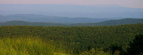
From the trailhead off Dry Run Road, we'll meander to the base of White Rock Mountain and begin the climb, steep at times, up WRM. Once near the summit of WRM, we'll continue behind this small peak and join an old logging road, recently improved, up the side of Jack Mountain to the intersection of Jack Mountain Trail, a road built by the CCC in the 1930s. At the summit of Jack Mountain, we'll enjoy lunch at the picnic area and then decide whether to return back the way we came, follow JM Trail back to Dry Run, follow the logging trail to Gum Tree Mtn trail, or continue along Jack Mountain to the Laurel Canyon trail. All trails lead back to Burnsville. Total hike distance is 6-9 miles depending on the route back.
Participants should bring sturdy shoes, plenty of water, a lunch, and whatever snacks you'd like to eat along the way. Check the forecast at www.weather.gov for 24484 or 24487 and plan accordingly.
Directions
Contact hike organizer for details but we'll depart from next to the big red barn on Dry Run Road in Burnsville, just north of the intersection of Dry Run Rd and Muddy Run Rd. Burnsville is in Bath County, about 3h20m from central Washington, 1h35m from Roanoke, and 1h from Staunton. There are many lodging and other outdoor activities in the area, including the Warm Springs Pools, Goshen Pass, and Ramsey's Draft.
About this event
From the trailhead off Dry Run Road, we'll meander to the base of White Rock Mountain and begin the climb, steep at times, up WRM. Once near the summit of WRM, we'll continue behind this small peak and join an old logging road, recently improved, up the side of Jack Mountain to the intersection of Jack Mountain Trail, a road built by the CCC in the 1930s. At the summit of Jack Mountain, we'll enjoy lunch at the picnic area and then decide whether to return back the way we came, follow JM Trail back to Dry Run, follow the logging trail to Gum Tree Mtn trail, or continue along Jack Mountain to the Laurel Canyon trail. All trails lead back to Burnsville. Total hike distance is 6-9 miles depending on the route back.
Participants should bring sturdy shoes, plenty of water, a lunch, and whatever snacks you'd like to eat along the way. Check the forecast at www.weather.gov for 24484 or 24487 and plan accordingly.
Directions to the trailhead
Get directionsContact hike organizer for details but we'll depart from next to the big red barn on Dry Run Road in Burnsville, just north of the intersection of Dry Run Rd and Muddy Run Rd. Burnsville is in Bath County, about 3h20m from central Washington, 1h35m from Roanoke, and 1h from Staunton. There are many lodging and other outdoor activities in the area, including the Warm Springs Pools, Goshen Pass, and Ramsey's Draft.
Who's going (1)
 GUEST MEMBER
Questions about this event?
Questions for the host, vahikerguy, about route details, carpooling, or what to bring? Ask in the event discussion below.
Event discussion
No comments yet.
Log in to join the conversation.