
Canyon View Trail & The Grotto Trail
<p> Rock formations, streams, waterfalls, giant boulders and The Grotto</p>
Canyon View Trail & The Grotto Trail
<p> Rock formations, streams, waterfalls, giant boulders and The Grotto</p>
Details
Date: Sunday, April 17, 2011
Time: 9:45 AM
Length: 7 miles roundtrip – 4 hours
Difficulty: Moderate
Configuration: In and back each segment
Exposure: Sun/Shade
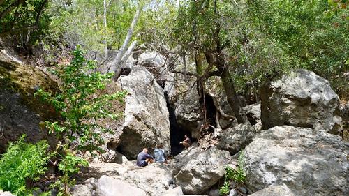
Circle X Ranch is located on the grounds of a former Boy Scout camp about 5 miles north of the Pacific Ocean and provides a great sampling of some of the best scenery in the Santa Monica Mountains with open fields, shady streambeds, a Live Oak forest and incredible volcanic/sandstone rock walls/formations. It ends in a lush grotto overgrown with oaks, bay laurel, sycamores and ferns. Nearby is Sandstone Peak, the highest point in the Santa Monica Mountain range at 3111 feet.
CANYON VIEW TRAIL - Length: 1.9 miles each way. Elevation change: 500 feet. This trail parallels Yerba Buena Road running from the Sandstone Peak trail head to the grotto trail near the group campground at Circle X ranch. The trail provides excellent views.
GROTTO TRAIL - Length: 1.6 miles each way. Elevation change: 500 feet. The trail traverses the hillsides and West Fork of the Arroyo Sequit. The Grotto is below a small waterfall.
Directions
DIRECTIONS – FROM the101 Fwy to trailhead is about 35 minutes. Please plan your commute accordingly. Take the Westlake BL/CA 23 exit
Turn left at S Westlake BL/CA 23 5.4 miles. As you approach the intersection of Westlake BL and Portrero Rd, stay left. At Westlake BL and Carlisle, stay left and continue on Westlake Bl/ CA23
At the Mulholland West/East split stay right on Mulholland West. Continue on CA-23/Mulholland Hwy 2.1 miles.
Turn right at Little Sycamore Canyon Rd 1.9 miles. Do not turn left onto Decker Rd!!
Little Sycamore Canyon Rd becomes Yerba Buena Rd, continue for 2.7 miles.
Navigation system coordinates: +34° 6' 41.82", -118° 55' 35.34"
As you are traveling on Yerba Buena Rd, you will pass a parking area that has a parking lot on each side of the road. This is the trailhead to the Mishe Mokwa trail. The next parking lot is on the right and is the Sandstone Peak/Backbone Trail parking lot. This is the parking lot where we will start our hike. If you reach the Circle X Ranger station you have gone to far. We will gather in the trailhead parking lot.
From PCH North, Hwy 1
Northbound on Hwy 1, turn right on Yerba Buena and go about 6 miles. Parking lot is on the left.
WHAT TO BRING: Good hiking boots/shoes, especially if you do the optional Sandstone Peak hike. We will be crossing a few streams and depending on the water level, your shoes may get wet. A hiking/trekking pole may be useful for stream crossing. Pack a lunch and lots of water… a hat/sunscreen.
CARPOOLING: Contact other members to carpool; share the conversation and travel expenses.
About this event
Date: Sunday, April 17, 2011
Time: 9:45 AM
Length: 7 miles roundtrip – 4 hours
Difficulty: Moderate
Configuration: In and back each segment
Exposure: Sun/Shade
Circle X Ranch is located on the grounds of a former Boy Scout camp about 5 miles north of the Pacific Ocean and provides a great sampling of some of the best scenery in the Santa Monica Mountains with open fields, shady streambeds, a Live Oak forest and incredible volcanic/sandstone rock walls/formations. It ends in a lush grotto overgrown with oaks, bay laurel, sycamores and ferns. Nearby is Sandstone Peak, the highest point in the Santa Monica Mountain range at 3111 feet.
CANYON VIEW TRAIL - Length: 1.9 miles each way. Elevation change: 500 feet. This trail parallels Yerba Buena Road running from the Sandstone Peak trail head to the grotto trail near the group campground at Circle X ranch. The trail provides excellent views.
GROTTO TRAIL - Length: 1.6 miles each way. Elevation change: 500 feet. The trail traverses the hillsides and West Fork of the Arroyo Sequit. The Grotto is below a small waterfall.
Directions to the trailhead
Get directionsDIRECTIONS – FROM the101 Fwy to trailhead is about 35 minutes. Please plan your commute accordingly. Take the Westlake BL/CA 23 exit
Turn left at S Westlake BL/CA 23 5.4 miles. As you approach the intersection of Westlake BL and Portrero Rd, stay left. At Westlake BL and Carlisle, stay left and continue on Westlake Bl/ CA23
At the Mulholland West/East split stay right on Mulholland West. Continue on CA-23/Mulholland Hwy 2.1 miles.
Turn right at Little Sycamore Canyon Rd 1.9 miles. Do not turn left onto Decker Rd!!
Little Sycamore Canyon Rd becomes Yerba Buena Rd, continue for 2.7 miles.
Navigation system coordinates: +34° 6' 41.82", -118° 55' 35.34"
As you are traveling on Yerba Buena Rd, you will pass a parking area that has a parking lot on each side of the road. This is the trailhead to the Mishe Mokwa trail. The next parking lot is on the right and is the Sandstone Peak/Backbone Trail parking lot. This is the parking lot where we will start our hike. If you reach the Circle X Ranger station you have gone to far. We will gather in the trailhead parking lot.
From PCH North, Hwy 1
Northbound on Hwy 1, turn right on Yerba Buena and go about 6 miles. Parking lot is on the left.
WHAT TO BRING: Good hiking boots/shoes, especially if you do the optional Sandstone Peak hike. We will be crossing a few streams and depending on the water level, your shoes may get wet. A hiking/trekking pole may be useful for stream crossing. Pack a lunch and lots of water… a hat/sunscreen.
CARPOOLING: Contact other members to carpool; share the conversation and travel expenses.
Who's going (3)

Questions about this event?
Questions for the host, Menard, about route details, carpooling, or what to bring? Ask in the event discussion below.
Event discussion
No comments yet.
Log in to join the conversation.