
The Tripyramids Hike
<p>The Tripyramids have three summits, but only the North and Middle peaks count as official 4000 footers.</p>
The Tripyramids Hike
<p>The Tripyramids have three summits, but only the North and Middle peaks count as official 4000 footers.</p>
Details
The Tripyramids have three summits, but only the North and Middle peaks count as official 4000 footers.
There are multiple approaches to these peaks. We will be taking the Pend Bend Brook Trail. The Pine Bend trail leaves the Kancamagus highway 1 mile west of Sabbaday falls picnic area. Parts of the trail are steep with rough terrain.
This hike is considered strenuous. Hiking time is approximately 7.5 hours. Round trip distance is 9.6 miles with both summits. Elevation gain is 3,450 feet.
The Tripyramids consist of three peaks: North Tripyramid [4,140 ft.], Middle Tripyramid [4,110 ft.], and South Tripyramid [4,090 ft.].
This hike begins gentle with many brook crossings. After 2.1 miles and entering the Sandwich Range Wilderness, the real hiking begins with the trail becoming rough and steep as it ascends the north bank of the brook valley. At 3.2 miles we reach the Scaur Ridge trail where we attack the final steep, rough and rocky climb to the North Peak with several scrambles over icy ledges so MicroSpikes are recommended. We'll then tag the two peaks and return the way we came.
This is an advanced hike with steep sections. This hike is not for slow hikers. If you have any doubt, please contact us. If you are up to it, it will be a great hike with fantastic views.
Event Coordinators: Mike Boisvert and Jon Normand
After The Hike: We'll either have a BBQ or order out for pizza back at my house in Waterville Valley so bring a change of clothes. I have lots of towels and everyone can take showers to clean up.
Lodging Option: I have 8 bunks available with linen for both Friday and Saturday nights at my house in Waterville Valley for $20 [each night]. You can use the kitchen facilities and store beverages/food in the fridge. I serve coffee in the morning and a continental breakfast. Contact me to RSVP. SPACE IS LIMITED TO EIGHT GUYS.
Directions
Roadside on NH Route 112 (Kancamagus Highway) one mile W of Sabbaday Falls picnic area and county line, elevation about 1380 feet
44.0016°N, 71.4130°W (WGS84)
From Exit 32 of I-93, take NH Route 112 E over Kancamagus Pass about 19.5 miles (about 2.9 miles beyond Lily Pond), roadside parking on R. We will be driving a blue Toyota FJ Cruiser.
About this event
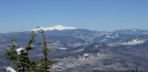
The Tripyramids have three summits, but only the North and Middle peaks count as official 4000 footers.
There are multiple approaches to these peaks. We will be taking the Pend Bend Brook Trail. The Pine Bend trail leaves the Kancamagus highway 1 mile west of Sabbaday falls picnic area. Parts of the trail are steep with rough terrain.
This hike is considered strenuous. Hiking time is approximately 7.5 hours. Round trip distance is 9.6 miles with both summits. Elevation gain is 3,450 feet.
The Tripyramids consist of three peaks: North Tripyramid [4,140 ft.], Middle Tripyramid [4,110 ft.], and South Tripyramid [4,090 ft.].
This hike begins gentle with many brook crossings. After 2.1 miles and entering the Sandwich Range Wilderness, the real hiking begins with the trail becoming rough and steep as it ascends the north bank of the brook valley. At 3.2 miles we reach the Scaur Ridge trail where we attack the final steep, rough and rocky climb to the North Peak with several scrambles over icy ledges so MicroSpikes are recommended. We'll then tag the two peaks and return the way we came.
This is an advanced hike with steep sections. This hike is not for slow hikers. If you have any doubt, please contact us. If you are up to it, it will be a great hike with fantastic views.
Event Coordinators: Mike Boisvert and Jon Normand
After The Hike: We'll either have a BBQ or order out for pizza back at my house in Waterville Valley so bring a change of clothes. I have lots of towels and everyone can take showers to clean up.
Lodging Option: I have 8 bunks available with linen for both Friday and Saturday nights at my house in Waterville Valley for $20 [each night]. You can use the kitchen facilities and store beverages/food in the fridge. I serve coffee in the morning and a continental breakfast. Contact me to RSVP. SPACE IS LIMITED TO EIGHT GUYS.
Directions to the trailhead
Get directionsRoadside on NH Route 112 (Kancamagus Highway) one mile W of Sabbaday Falls picnic area and county line, elevation about 1380 feet
44.0016°N, 71.4130°W (WGS84)
From Exit 32 of I-93, take NH Route 112 E over Kancamagus Pass about 19.5 miles (about 2.9 miles beyond Lily Pond), roadside parking on R. We will be driving a blue Toyota FJ Cruiser.
Who's going (2)
 GUEST MEMBER
Questions about this event?
Reach out to the host, Gandalf, for route details, carpooling, or what to bring.
Email the hostYou can also ask in the event discussion below.
Event discussion
No comments yet.
Log in to join the conversation.