
Middlesex Fells Skyline Trail Hike
<p>Enjoy the Skyline Trail at the Fells, with excellent views of Boston, the Winchester Reservoirs, and the Atlantic Ocean.</p>
Middlesex Fells Skyline Trail Hike
<p>Enjoy the Skyline Trail at the Fells, with excellent views of Boston, the Winchester Reservoirs, and the Atlantic Ocean.</p>
Details
The Skyline trail covers much of the eastern side of the Middlesex Fells Reservation. This is a 6.8 mile trail, which has some short but steep ascents and descents as it follows around the Winchester Reservoir. Elevation climb is less that 1000 feet. This hike affords an excellent view of Boston and the metro north area, as well as a good view of the ocean out towards Revere. These views are from 2 seperate towers which we will climb at either end of this loop hike (small detours off the main trail). The main part of the trail is wooded, with some views of the reservoir.
This is a good moderate hike for those who would like to experience something closer to Boston. The T runs close to the location of this hike for those who live in the area but do not have a car. Please feel free to e-mail for info.
Directions
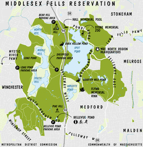
We will meet at the info kiosk at Bellevue Pond off of south Border road at 10 AM. Take I-93 to Exit # 33 which will put you on a Rotary (Roosevelt Circle). Follow the rotary around to South Border Road which goes off to the West. Follow South Border Road through the S curves and there is a small pulloff to the right which comes up quickly. This is where we will meet.
About this event
The Skyline trail covers much of the eastern side of the Middlesex Fells Reservation. This is a 6.8 mile trail, which has some short but steep ascents and descents as it follows around the Winchester Reservoir. Elevation climb is less that 1000 feet. This hike affords an excellent view of Boston and the metro north area, as well as a good view of the ocean out towards Revere. These views are from 2 seperate towers which we will climb at either end of this loop hike (small detours off the main trail). The main part of the trail is wooded, with some views of the reservoir.
This is a good moderate hike for those who would like to experience something closer to Boston. The T runs close to the location of this hike for those who live in the area but do not have a car. Please feel free to e-mail for info.
Directions to the trailhead
Get directionsWe will meet at the info kiosk at Bellevue Pond off of south Border road at 10 AM. Take I-93 to Exit # 33 which will put you on a Rotary (Roosevelt Circle). Follow the rotary around to South Border Road which goes off to the West. Follow South Border Road through the S curves and there is a small pulloff to the right which comes up quickly. This is where we will meet.
Who's going (5)
 GUEST MEMBER
 GUEST MEMBER
 SUSTAINING
 SUSTAINING
Questions about this event?
Questions for the host, outdoorsyguy79, about route details, carpooling, or what to bring? Ask in the event discussion below.
Event discussion
No comments yet.
Log in to join the conversation.