
Mt Jefferson Hike
<p>This is a long but highly rewarding approach up beautiful Castle Ravine with the usual Northern Presidentials rock-hop; then down the Castle Trail with terrific views and some tough scrambling along the spectacular Castles!</p>
Mt Jefferson Hike
<p>This is a long but highly rewarding approach up beautiful Castle Ravine with the usual Northern Presidentials rock-hop; then down the Castle Trail with terrific views and some tough scrambling along the spectacular Castles!</p>
Details
This is a long but highly rewarding approach up beautiful Castle Ravine with the usual Northern Presidentials rock-hop; then down the Castle Trail with terrific views and some tough scrambling along the spectacular Castles!
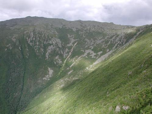
Mt. Jefferson [5,716'] has 360-degree views with the most striking view being down the Great Gulf with the Carter Range beyond. Castle Ravine is wild, steep, rocky with many brook crossings that may be difficult at moderate/high water; and is one the most least visited glacial cirques in the Whites. Our descent down the sharp, spectacular Castellated Ridge [Castle Trail] which narrows into wild, fin-like rock formations known as "The Castles" provides unforgettable views. In bad weather, it can be a dangerous trail because of long and continuous exposure above treeline.
Click Here For More Information: http://www.hikenewengland.com/Jefferson990905.html
Distance: This hike is a total of 10.2 miles basically using the Castle Ravine to ascend and the Castle Trail to descend. At 1.3 miles we leave the Castle Trail to reach the Castle Ravine Trail via the Israel Ridge Path. At 3.2 miles we reach the lower junction of the Link Trail. We reach the summit of Mt. Jefferson at 5.2 miles and then descend via the Castle Trail reaching "The Castles" 5.7 miles. The ridge then becomes very narrow and the trail becomes steep and rough with some fairly difficult scrambles.
Time: 8-9 hours
Elevation Gain: 4,240 feet
This is NOT a dog-friendly hike.
Carpooling: Contact other members to carpool, share the conversation and travel expenses. Contact us if you want to carpool with us from Exit 28.
Cell Phone #: Will be provided to participants in an email.
Event Coordinators: Mike Boisvert and Jon Normand
After The Hike: We'll either have a BBQ or order out for pizza back at my house in Waterville Valley so bring a change of clothes. I have lots of towels and everyone can take showers to clean up.
Lodging Option: I have 8 bunks available with linen for both Friday and Saturday nights at my house in Waterville Valley for $20 [each night]. You can use the kitchen facilities and store beverages/food in the fridge. I serve coffee in the morning and a continental breakfast. Contact me to RSVP. SPACE IS LIMITED TO EIGHT GUYS.
Directions
The trailhead for this hike is located in Randolph, New Hampshire on the south side of Route 2.
From I-93:
- From I-93, take Exit 36 for Rt. 3 North
- Follow Rt. 3 North for about 10 miles which will bring you to the junction of Routes 302 and 3 in Carroll [Twin Mountain]
- Continue driving north on Rt. 3 for 2 miles, then turn right at the blinking light, onto Rt. 115
- Follow Rt. 115 for about 13 miles until it ends upon meeting Rt. 2
- Turn right onto Rt. 2 East
- Follow Rt. 2 East for 4.2 miles, then turn right into the parking area [this parking area is not very visible from the road and can easily be missed]
- We'll be driving a blue Toyota FJ Cruiser
From Rt. 16:
- Take Rt. 16 into the town of Gorham
- At the western-most junction of Routes 2 and 16 [this will be the first junction if heading south on Rt. 16; the second junction when heading north], head west on Rt. 2
- Follow Rt. 2 for 8.3 miles, then turn left into a parking area [this parking area is not very visible from the road and can easily be missed]
- We'll be driving a blue Toyota FJ Cruiser
About this event
This is a long but highly rewarding approach up beautiful Castle Ravine with the usual Northern Presidentials rock-hop; then down the Castle Trail with terrific views and some tough scrambling along the spectacular Castles!
Mt. Jefferson [5,716'] has 360-degree views with the most striking view being down the Great Gulf with the Carter Range beyond. Castle Ravine is wild, steep, rocky with many brook crossings that may be difficult at moderate/high water; and is one the most least visited glacial cirques in the Whites. Our descent down the sharp, spectacular Castellated Ridge [Castle Trail] which narrows into wild, fin-like rock formations known as "The Castles" provides unforgettable views. In bad weather, it can be a dangerous trail because of long and continuous exposure above treeline.
Click Here For More Information: http://www.hikenewengland.com/Jefferson990905.html
Distance: This hike is a total of 10.2 miles basically using the Castle Ravine to ascend and the Castle Trail to descend. At 1.3 miles we leave the Castle Trail to reach the Castle Ravine Trail via the Israel Ridge Path. At 3.2 miles we reach the lower junction of the Link Trail. We reach the summit of Mt. Jefferson at 5.2 miles and then descend via the Castle Trail reaching "The Castles" 5.7 miles. The ridge then becomes very narrow and the trail becomes steep and rough with some fairly difficult scrambles.
Time: 8-9 hours
Elevation Gain: 4,240 feet
This is NOT a dog-friendly hike.
Carpooling: Contact other members to carpool, share the conversation and travel expenses. Contact us if you want to carpool with us from Exit 28.
Cell Phone #: Will be provided to participants in an email.
Event Coordinators: Mike Boisvert and Jon Normand
After The Hike: We'll either have a BBQ or order out for pizza back at my house in Waterville Valley so bring a change of clothes. I have lots of towels and everyone can take showers to clean up.
Lodging Option: I have 8 bunks available with linen for both Friday and Saturday nights at my house in Waterville Valley for $20 [each night]. You can use the kitchen facilities and store beverages/food in the fridge. I serve coffee in the morning and a continental breakfast. Contact me to RSVP. SPACE IS LIMITED TO EIGHT GUYS.
Directions to the trailhead
Get directionsThe trailhead for this hike is located in Randolph, New Hampshire on the south side of Route 2.
From I-93:
- From I-93, take Exit 36 for Rt. 3 North
- Follow Rt. 3 North for about 10 miles which will bring you to the junction of Routes 302 and 3 in Carroll [Twin Mountain]
- Continue driving north on Rt. 3 for 2 miles, then turn right at the blinking light, onto Rt. 115
- Follow Rt. 115 for about 13 miles until it ends upon meeting Rt. 2
- Turn right onto Rt. 2 East
- Follow Rt. 2 East for 4.2 miles, then turn right into the parking area [this parking area is not very visible from the road and can easily be missed]
- We'll be driving a blue Toyota FJ Cruiser
From Rt. 16:
- Take Rt. 16 into the town of Gorham
- At the western-most junction of Routes 2 and 16 [this will be the first junction if heading south on Rt. 16; the second junction when heading north], head west on Rt. 2
- Follow Rt. 2 for 8.3 miles, then turn left into a parking area [this parking area is not very visible from the road and can easily be missed]
- We'll be driving a blue Toyota FJ Cruiser
Who's going (3)



Questions about this event?
Reach out to the host, Gandalf, for route details, carpooling, or what to bring.
Email the hostYou can also ask in the event discussion below.
Event discussion
No comments yet.
Log in to join the conversation.