
Mt. Tremont and Owl's Cliff Traverse
<p> A nice autumn traverse across two peaks in the Sawyer River Wilderness area.</p>
Mt. Tremont and Owl's Cliff Traverse
<p> A nice autumn traverse across two peaks in the Sawyer River Wilderness area.</p>
Details
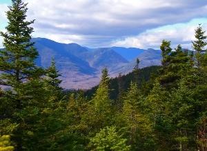
Join me for this 7.8 mile hike across the summits of Mount Tremont (3371') and Owl's Cliff (2940') using the Mt. Tremont and Brunel Trails. This trip has some steep sections along the trails and is often considered to be as tough as some 4000-footers. The bare, rocky summit of Mt. Tremont, one of the NE Most Prominent Peaks, rewards with views into the surrounding wilderness and peaks along with views of Sawyer Pond. Owl's Cliff is an impressive shear cliff often used by mountain climbers. There is a short spur trail to its summit, which affords views into the Sandwich Range and the wilderness to the west. There is about 2450' elevation gain to Mt. Tremont, 700' elvation loss to the col and 370' elevation gain up to Owl's Cliff. Trailhead: From the Kancamagus Highway (Rt. 112), head east from Lincoln and bear left onto Bear Notch Road. The trailhead will be on the left after approximately 1 to 1.2 miles...a short distance past the gated Rob Brook Road (if you pass the seasonal gates, you've gone too far). We'll meet up and carpool over to the trailhead on Rt. 302. Look for a grey Hyundai Elantra. What to Bring: Typical fall hiking gear should be appropriate: shorts or convertible hiking pants, good sturdy hiking boots with thick socks and a windbreaker/rain gear (just in case). Also bring along lunch, snacks and plenty of water (2-l minimum is recommended). Optionally, pack bug repellent and sunscreen and anything else you may require for a day hike. Afterwards: We should be completed with the hike by 4-5 PM. If there is sufficient interest, we'll cap the day off with dinner/drinks in the area afterwards.
Directions
From the Kancamagus Highway (Rt. 112), head east from Lincoln and bear left onto Bear Notch Road. The trailhead will be on the left after approximately 1 to 1.2 miles...a short distance past the gated Rob Brook Road (if you pass the seasonal gates, you've gone too far). We'll meet up and carpool over to the trailhead on Rt. 302. Look for a grey Hyundai Elantra.
About this event
Join me for this 7.8 mile hike across the summits of Mount Tremont (3371') and Owl's Cliff (2940') using the Mt. Tremont and Brunel Trails. This trip has some steep sections along the trails and is often considered to be as tough as some 4000-footers. The bare, rocky summit of Mt. Tremont, one of the NE Most Prominent Peaks, rewards with views into the surrounding wilderness and peaks along with views of Sawyer Pond. Owl's Cliff is an impressive shear cliff often used by mountain climbers. There is a short spur trail to its summit, which affords views into the Sandwich Range and the wilderness to the west. There is about 2450' elevation gain to Mt. Tremont, 700' elvation loss to the col and 370' elevation gain up to Owl's Cliff. Trailhead: From the Kancamagus Highway (Rt. 112), head east from Lincoln and bear left onto Bear Notch Road. The trailhead will be on the left after approximately 1 to 1.2 miles...a short distance past the gated Rob Brook Road (if you pass the seasonal gates, you've gone too far). We'll meet up and carpool over to the trailhead on Rt. 302. Look for a grey Hyundai Elantra. What to Bring: Typical fall hiking gear should be appropriate: shorts or convertible hiking pants, good sturdy hiking boots with thick socks and a windbreaker/rain gear (just in case). Also bring along lunch, snacks and plenty of water (2-l minimum is recommended). Optionally, pack bug repellent and sunscreen and anything else you may require for a day hike. Afterwards: We should be completed with the hike by 4-5 PM. If there is sufficient interest, we'll cap the day off with dinner/drinks in the area afterwards.
Directions to the trailhead
Get directionsFrom the Kancamagus Highway (Rt. 112), head east from Lincoln and bear left onto Bear Notch Road. The trailhead will be on the left after approximately 1 to 1.2 miles...a short distance past the gated Rob Brook Road (if you pass the seasonal gates, you've gone too far). We'll meet up and carpool over to the trailhead on Rt. 302. Look for a grey Hyundai Elantra.
Who's going (4)
 GUEST MEMBER
Questions about this event?
Reach out to the host, shep5, for route details, carpooling, or what to bring.
Email the hostYou can also ask in the event discussion below.
Event discussion
No comments yet.
Log in to join the conversation.