
Mt. Adams via King Ravine
<p>A White Mountains classic: Mt. Adams via King Ravine</p>
Mt. Adams via King Ravine
<p>A White Mountains classic: Mt. Adams via King Ravine</p>
Details
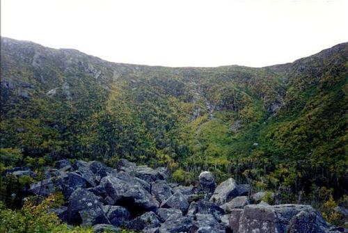
We will start from the Appalachia trailhead on Rt. 2 (1,306 ft.) and hike up to the summit of Mt. Adams (5,799 ft.) via the awesome King Ravine trail, where you will have lots of fun going through "The Subway," around, over, and through gigantic boulders. Of course, you can skip the fun by going up on "The Elevated," and watch your buddies suffer below you. After this, we will then scramble up the always tough headwall, onto the ridge and then on to the summit. If this is a clear day, the views of Mt. Washington from the summit of Mt. Adams are spectacular. We will return to Appalachia via the Air Line Trail, an equally awesome trail with great views. A good portion of this hike will be on very exposed terrain above treeline, so come prepared with good weatherproof outer clothing, and a fleece to warm up while at the summit. Also bring lots of water, lunch, and snacks. The hike up will be 4.6 miles and the return 4.3 for a total of 8.9 miles round trip. Rain will cancel this event.
Directions
We will meet at the Appalachia trailhead on US Rt. 2 about 7 miles west of Gorham, NH. Directions from I-93 are as follows: After going through Franconia Notch, I-93 widens again to four lanes. At the first exit after it widens, get off I-93 and take Rt. 3 to the town of Twin Mountain. Go through the intersection with US 302 (there's a traffic light here) and in about two miles turn right onto NH Rt. 115. Stay on 115 for 9 to 10 miles as it dead-ends on US 2. Turn right (east) and go about 7 miles to the parking area for the Appalachia trailhead. About a mile before Appalachia, you will see Lowe's Store on your left. This is a good place to buy last minute stuff you may need on the hike.
About this event
We will start from the Appalachia trailhead on Rt. 2 (1,306 ft.) and hike up to the summit of Mt. Adams (5,799 ft.) via the awesome King Ravine trail, where you will have lots of fun going through "The Subway," around, over, and through gigantic boulders. Of course, you can skip the fun by going up on "The Elevated," and watch your buddies suffer below you. After this, we will then scramble up the always tough headwall, onto the ridge and then on to the summit. If this is a clear day, the views of Mt. Washington from the summit of Mt. Adams are spectacular. We will return to Appalachia via the Air Line Trail, an equally awesome trail with great views. A good portion of this hike will be on very exposed terrain above treeline, so come prepared with good weatherproof outer clothing, and a fleece to warm up while at the summit. Also bring lots of water, lunch, and snacks. The hike up will be 4.6 miles and the return 4.3 for a total of 8.9 miles round trip. Rain will cancel this event.
Directions to the trailhead
Get directionsWe will meet at the Appalachia trailhead on US Rt. 2 about 7 miles west of Gorham, NH. Directions from I-93 are as follows: After going through Franconia Notch, I-93 widens again to four lanes. At the first exit after it widens, get off I-93 and take Rt. 3 to the town of Twin Mountain. Go through the intersection with US 302 (there's a traffic light here) and in about two miles turn right onto NH Rt. 115. Stay on 115 for 9 to 10 miles as it dead-ends on US 2. Turn right (east) and go about 7 miles to the parking area for the Appalachia trailhead. About a mile before Appalachia, you will see Lowe's Store on your left. This is a good place to buy last minute stuff you may need on the hike.
Who's going (2)
 GUEST MEMBER
 SUSTAINING
Questions about this event?
Reach out to the host, JPHiker, for route details, carpooling, or what to bring.
Email the hostYou can also ask in the event discussion below.
Event discussion
No comments yet.
Log in to join the conversation.