
Mt. Garfield Hike
<p> Hike up to Mt. Garfield for grand views of Franconia ridge and the Pemi wilderness.</p>
Mt. Garfield Hike
<p> Hike up to Mt. Garfield for grand views of Franconia ridge and the Pemi wilderness.</p>
Details
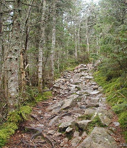
We will be hiking up and down the Garfield Trail (start elevation 1,500 ft.) to the open summit of Mt. Garfield (elevation 4,500 ft.), for a total of 10 miles round trip. Most of the grading of this trail is moderate, except for the half mile below the summit where it is outstandingly steep. The summit is bare, and it offers great views on a clear day. Come prepared for a long day, and bring plenty of water and snacks/lunch. Also, bring a good weatherproofed jacket, and a light fleece, as it might get chilly up at the summit. Rain will cancel this event.
Directions
We will meet at the trailhead parking lot on the Gale River Loop Road (FR 92). This road starts at US 3, about 4 miles south of the town of Twin Mountain, or about 3 miles north of where US 3 leaves I-93 just north of Franconia Notch. The trailhead is reached by leaving US 3 at a small picnic area 3/10 of a mile south of the intersection from Trudeau Road (this intersection is called Five Corners and there is a sign for Trudeau Road). When you turn into the Gale River Loop Road, avoid a right fork, and continue south for 1.2 miles, at that point, bear left and cross a bridge. The trailhead parking lot is on the right shortly after you cross the bridge. Btw, the Gale River trailhead is about another 1.5 mile on this same road, so if you get to that trailhead, you'll know that you went way too far.
About this event
We will be hiking up and down the Garfield Trail (start elevation 1,500 ft.) to the open summit of Mt. Garfield (elevation 4,500 ft.), for a total of 10 miles round trip. Most of the grading of this trail is moderate, except for the half mile below the summit where it is outstandingly steep. The summit is bare, and it offers great views on a clear day. Come prepared for a long day, and bring plenty of water and snacks/lunch. Also, bring a good weatherproofed jacket, and a light fleece, as it might get chilly up at the summit. Rain will cancel this event.
Directions to the trailhead
Get directionsWe will meet at the trailhead parking lot on the Gale River Loop Road (FR 92). This road starts at US 3, about 4 miles south of the town of Twin Mountain, or about 3 miles north of where US 3 leaves I-93 just north of Franconia Notch. The trailhead is reached by leaving US 3 at a small picnic area 3/10 of a mile south of the intersection from Trudeau Road (this intersection is called Five Corners and there is a sign for Trudeau Road). When you turn into the Gale River Loop Road, avoid a right fork, and continue south for 1.2 miles, at that point, bear left and cross a bridge. The trailhead parking lot is on the right shortly after you cross the bridge. Btw, the Gale River trailhead is about another 1.5 mile on this same road, so if you get to that trailhead, you'll know that you went way too far.
Who's going (2)
 SUSTAINING
 GUEST MEMBER
Questions about this event?
Reach out to the host, JPHiker, for route details, carpooling, or what to bring.
Email the hostYou can also ask in the event discussion below.
Event discussion
No comments yet.
Log in to join the conversation.