
N. & S. Baldface Mtns. Hike
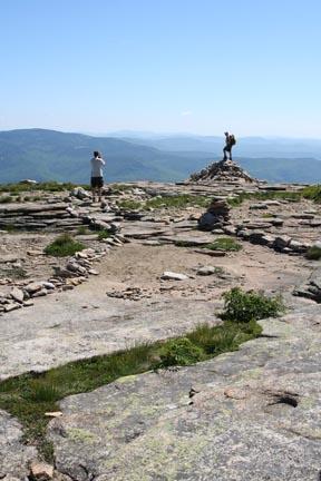
<p>One of the finest ridge traverses of the White Mountains, with about four miles of open ledge walking. </p>
N. & S. Baldface Mtns. Hike
<p>One of the finest ridge traverses of the White Mountains, with about four miles of open ledge walking. </p>
Details
One of the finest ridge traverses of the White Mountains, with about four miles of open ledge walking.
Per SummitPost: "Here's an argument against peak bagging: while you're spending your weekends chasing all 48 of New Hampshire's 4000-footers, you might miss some small but spectacular gems like Cardigan, Chocorua, and the two peaks described here."
Unlike a lot of 4000-footers, a significant portion of Baldface is above treeline. Along the way, the hike encounters gorges, technical scramble sections [that will make some people nervous], cairn-to-cairn navigation, and even a bit of easy creek-hopping.
Distance: We'll follow the Baldface Circle Trail on the steep climb to South Baldface and across North Baldface, descend via the ledgy Bicknell Ridge Trail and lower Baldface Circle Trail. This loop is 9.7 miles.
Time: 6.40 book time
Elevation Gain: 3,600 feet
This is NOT a dog-friendly hike.
Hike description and other info available at Summit Post.
Carpooling: Contact other members to carpool, share the conversation and travel expenses. Contact us if you want to carpool with us from Exit 28.
Cell Phone #: Will be provided to participants in an email.
After The Hike: We'll grab dinner in North Conway so bring a change of clothes.
Lodging Option: I have 8 bunks available with linen for both Friday and Saturday night at my house in Waterville Valley for $20 each night. You can use the kitchen facilities and store beverages/food in the fridge. I serve coffee in the morning and a continental breakfast. Contact me to RSVP. SPACE IS LIMITED TO EIGHT GUYS.
Directions
Getting to Conway from points south: If traffic is light, you can take rte 16 some 75 miles all the way from Portsmouth NH, which is on Interstate 95. If you prefer to maximize your highway miles, you could take Interstate 93 north, and turn east on your choice of rte 25, 112, or 302.
From Conway NH, head east on 302/113 to Fryeburg ME, where 113 North takes a sharp left (not well-marked, but if you see the sign for 5/113 South pointing right, backtrack a couple of blocks). Take route 113 (paved but bumpy) north about twenty miles. The small parking lot - plowed in winter- is on the right shortly after a huge brown sign. The trail is a short distance further north on the opposite side of the road. There's a sign, though it's partly obscured by a telephone pole.
About this event
One of the finest ridge traverses of the White Mountains, with about four miles of open ledge walking.
Per SummitPost: "Here's an argument against peak bagging: while you're spending your weekends chasing all 48 of New Hampshire's 4000-footers, you might miss some small but spectacular gems like Cardigan, Chocorua, and the two peaks described here."
Unlike a lot of 4000-footers, a significant portion of Baldface is above treeline. Along the way, the hike encounters gorges, technical scramble sections [that will make some people nervous], cairn-to-cairn navigation, and even a bit of easy creek-hopping.
Distance: We'll follow the Baldface Circle Trail on the steep climb to South Baldface and across North Baldface, descend via the ledgy Bicknell Ridge Trail and lower Baldface Circle Trail. This loop is 9.7 miles.
Time: 6.40 book time
Elevation Gain: 3,600 feet
This is NOT a dog-friendly hike.
Hike description and other info available at Summit Post.
Carpooling: Contact other members to carpool, share the conversation and travel expenses. Contact us if you want to carpool with us from Exit 28.
Cell Phone #: Will be provided to participants in an email.
After The Hike: We'll grab dinner in North Conway so bring a change of clothes.
Lodging Option: I have 8 bunks available with linen for both Friday and Saturday night at my house in Waterville Valley for $20 each night. You can use the kitchen facilities and store beverages/food in the fridge. I serve coffee in the morning and a continental breakfast. Contact me to RSVP. SPACE IS LIMITED TO EIGHT GUYS.
Directions to the trailhead
Get directionsGetting to Conway from points south: If traffic is light, you can take rte 16 some 75 miles all the way from Portsmouth NH, which is on Interstate 95. If you prefer to maximize your highway miles, you could take Interstate 93 north, and turn east on your choice of rte 25, 112, or 302.
From Conway NH, head east on 302/113 to Fryeburg ME, where 113 North takes a sharp left (not well-marked, but if you see the sign for 5/113 South pointing right, backtrack a couple of blocks). Take route 113 (paved but bumpy) north about twenty miles. The small parking lot - plowed in winter- is on the right shortly after a huge brown sign. The trail is a short distance further north on the opposite side of the road. There's a sign, though it's partly obscured by a telephone pole.
Who's going (4)

Questions about this event?
Reach out to the host, Gandalf, for route details, carpooling, or what to bring.
Email the hostYou can also ask in the event discussion below.
Event discussion
No comments yet.
Log in to join the conversation.