
Peak bag Mts. Whiteface and Passaconaway
<p>Peak bag Mounts Whiteface and Passaconaway. Two 4K mountains in the Sandwich Range of the White Mountains.</p>
Peak bag Mts. Whiteface and Passaconaway
<p>Peak bag Mounts Whiteface and Passaconaway. Two 4K mountains in the Sandwich Range of the White Mountains.</p>
Details
THE TRIP DATE HAS CHANGED FROM 6/5 to 6/12 DUE TO A POOR WEATHER FORCAST. NO OTHER TRIP PLAN DETAILS HAVE BEEN CHANGED.
Peak bag Mounts Whiteface and Passaconaway. Two 4K mountains in the Sandwich Range of the White Mountains. Be prepared for a challenging hike with steep scrambles and some distance. Poor weather will postpone this hike.
Difficulty: Strenuous (terrain, elevation, endurance)
Distance: 12.6 miles
Elevation Gain: roughly 3680 feet
Hiking Pace: Steady with necessary hydration and scenic spot stops
Start Time: 9:00am
The Mountains
Both Mt. Whiteface (4020 feet) and Mt. Passaconaway (4043 feet) are mountains on the NH 48 4K list. They are located in the southern part of the White Mountains within the Sandwich Range. Though these mountains have less elevation than the majority of the other 4K mountains they offer a good strenuous day climb. A feature on the trip includes a hike along a ridgeline which follows the top of the Bowl Natural Area. This cirque, which is formed from both mountains, has never been logged. Both summits are wooded and offer some views. There are other opportunities for views during the hike.
Our Route
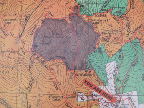
From the Ferncroft Road parking lot we will hike the Blueberry Ledge Trail to the ledges of Mt. Whiteface (3.9mi.). There will be several steep scrambles along this route with some having steps drilled into the rock. We will continue along the Blueberry Ledge Trail than the Rollins Trail, passing the Mt. Whiteface summit, to Dicey's Mill Trail (2.5mi.). Here we will turn left and hike Dicey's Mill Trail and the East Loop Trail to summit Mt. Passaconaway than backtrack to the Blueberry Ledge/ Dicey's Mill junction (1.6mi. total). There is some steep and rough trail along this stretch. We will descend the Dicey's Mill Trail which has a moderate grade and good footing back to the parking lot (4.6mi.).
What To Bring
Sturdy and trail tested hiking shoes are a must. Avoid the use of cotton clothing. Jeans will not be permitted on the hike. Bring plenty of water (suggest at least 2 liters), a lunch, and high energy snacks. Bug spray recommended.
Misc. Trip Notes
Pockets of snow may still exist though the majority of these trails are on south facing slopes.
There is no parking fee. The parking area is on private land and maintained by the Wonalancet Out Door Club. Check out: www.wnoc.org
There are a few springs along the trail, dependability unknown. Bring enough water for the entire trip.
Directions
All mileage is somewhat accurate.
Trail Head Parking Lot: N43"54.830' W71"21.433'
From Route 93 (93 exit 24 to 3 south to 113 east to 113A to Ferncroft Rd.): Take exit 24 (Ashland) onto Route 3 south. Drive 4.5 miles and turn left onto Route 113 east. Drive 15.3 miles and turn onto Route 113A. Drive 6.7 miles and turn left onto Ferncroft Road. Ferncroft Road is broken pavement at first than dirt. It is just before a white church along the side of a very large grass field. Drive down Ferncroft Rd. for about a half mile and follow the trail parking signs.
From Route 16 (113 west to 113A to Ferncroft Rd.): Turn onto Route 113 west in the town of Chocorua. Drive 2.9 miles and turn right onto Route 113A. Drive 6.5 miles and turn right onto Ferncroft Road. Ferncroft Road is broken pavement at first than dirt. It is just after a white church along the side of a very large grass field. Drive down Ferncroft Rd. for about a half mile and follow the trail parking signs.
About this event
THE TRIP DATE HAS CHANGED FROM 6/5 to 6/12 DUE TO A POOR WEATHER FORCAST. NO OTHER TRIP PLAN DETAILS HAVE BEEN CHANGED.
Peak bag Mounts Whiteface and Passaconaway. Two 4K mountains in the Sandwich Range of the White Mountains. Be prepared for a challenging hike with steep scrambles and some distance. Poor weather will postpone this hike.
Difficulty: Strenuous (terrain, elevation, endurance)
Distance: 12.6 miles
Elevation Gain: roughly 3680 feet
Hiking Pace: Steady with necessary hydration and scenic spot stops
Start Time: 9:00am
The Mountains
Both Mt. Whiteface (4020 feet) and Mt. Passaconaway (4043 feet) are mountains on the NH 48 4K list. They are located in the southern part of the White Mountains within the Sandwich Range. Though these mountains have less elevation than the majority of the other 4K mountains they offer a good strenuous day climb. A feature on the trip includes a hike along a ridgeline which follows the top of the Bowl Natural Area. This cirque, which is formed from both mountains, has never been logged. Both summits are wooded and offer some views. There are other opportunities for views during the hike.
Our Route
From the Ferncroft Road parking lot we will hike the Blueberry Ledge Trail to the ledges of Mt. Whiteface (3.9mi.). There will be several steep scrambles along this route with some having steps drilled into the rock. We will continue along the Blueberry Ledge Trail than the Rollins Trail, passing the Mt. Whiteface summit, to Dicey's Mill Trail (2.5mi.). Here we will turn left and hike Dicey's Mill Trail and the East Loop Trail to summit Mt. Passaconaway than backtrack to the Blueberry Ledge/ Dicey's Mill junction (1.6mi. total). There is some steep and rough trail along this stretch. We will descend the Dicey's Mill Trail which has a moderate grade and good footing back to the parking lot (4.6mi.).
What To Bring
Sturdy and trail tested hiking shoes are a must. Avoid the use of cotton clothing. Jeans will not be permitted on the hike. Bring plenty of water (suggest at least 2 liters), a lunch, and high energy snacks. Bug spray recommended.
Misc. Trip Notes
Pockets of snow may still exist though the majority of these trails are on south facing slopes.
There is no parking fee. The parking area is on private land and maintained by the Wonalancet Out Door Club. Check out: www.wnoc.org
There are a few springs along the trail, dependability unknown. Bring enough water for the entire trip.
Directions to the trailhead
Get directionsAll mileage is somewhat accurate.
Trail Head Parking Lot: N43"54.830' W71"21.433'
From Route 93 (93 exit 24 to 3 south to 113 east to 113A to Ferncroft Rd.): Take exit 24 (Ashland) onto Route 3 south. Drive 4.5 miles and turn left onto Route 113 east. Drive 15.3 miles and turn onto Route 113A. Drive 6.7 miles and turn left onto Ferncroft Road. Ferncroft Road is broken pavement at first than dirt. It is just before a white church along the side of a very large grass field. Drive down Ferncroft Rd. for about a half mile and follow the trail parking signs.
From Route 16 (113 west to 113A to Ferncroft Rd.): Turn onto Route 113 west in the town of Chocorua. Drive 2.9 miles and turn right onto Route 113A. Drive 6.5 miles and turn right onto Ferncroft Road. Ferncroft Road is broken pavement at first than dirt. It is just after a white church along the side of a very large grass field. Drive down Ferncroft Rd. for about a half mile and follow the trail parking signs.
Who's going (2)
 GUEST MEMBER
Questions about this event?
Log in to see who's hosting and to ask them questions in the event discussion.
Log in
Event discussion
No comments yet.
Log in to join the conversation.