
GetFit Hike #1: Castle in the Clouds Hike
<p>Join our GetFit hikes that progressively get harder culminating with a hike up a 4,000 footer, Mt. Pierce. This series is ideal for those of you who have been inactive this winter or want to get in shape to hike this summer.</p>
GetFit Hike #1: Castle in the Clouds Hike
<p>Join our GetFit hikes that progressively get harder culminating with a hike up a 4,000 footer, Mt. Pierce. This series is ideal for those of you who have been inactive this winter or want to get in shape to hike this summer.</p>
Details
If you are looking for a mellow hike that leads to a viewpoint that provides a broad vista over the Castle in the Clouds to Lake Winnipesaukee and beyond combined with spectacular waterfalls, then this may be just what you had in mind.
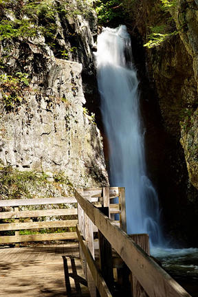
We will be taking short hikes on the Castle in the Clouds property. The Castle is a spectacular mountaintop estate that offers a 270-degree view of mountains and lakes. We will first take a 1.8 mile hike that includes the Oak Ridge Trail that leads to a viewpoint with views of the Belknap Range, Mt. Kearsarge, Mt, Cardigan, Red Hill, and many other small mountains. Then we'll take a 1 mile hike that includes the Brook Walk which flows through impressive gorges, into beautiful pools, and over rapids and spectacular waterfalls. Total elevation gain is about 300 feet.
After the hike: We'll have a casual meal lakeside at "The Docks" outdoors along the shore of Lake Winnipesauke in Meredith.
Event Coordinators: Mike Boisvert and Jon Normand
Directions
From South and West and I-93: Follow I-93 to Exit 23, then take Rt. 104 east towards Meredith. At end of Rt. 104, turn left (North) on Rte 3. In 1/2 mile, at lights, turn right (East) onto Rt. 25 and follow into Moultonborough. Turn right onto Rt. 109 South, go 2 miles, then bear left onto Rt. 171. Look for the Ossipee Park Road which is approx. 1 mile on left. If you've reached the Castle in the Clouds entrance you've gone too far. Read Ossipee Park Road Directions further below.
From the South: (Portsmouth, Rochester) and I-95: Take Rt. 16 north. Turn left onto Rt. 171 in Ossipee. Continue on Rt. 171 for approx. 16 miles. Ossipee Park Road will be on your right about 1 miles past the Castle in the Clouds entrance. Read Ossipee Park Road Directions further below.
From the North: Take Rte 16 south to Rt. 25 West in West Ossipee. Turn right onto Rt. 25 West and continue for approx. 10 miles. In Moultonboro, turn left (South) onto Rt. 109 south, go 2 miles, then bear left onto Rt. 171. Look for the Ossipee Park Road which is approx. 1 mile on left. If you've reached the Castle in the Clouds entrance you've gone too far. Read Ossipee Park Road Directions further below.
Ossipee Park Road Directions: Drive up Ossipee Park Road to the hiker parking area on the right just outside the back gate of the Castle grounds. We will be driving a blue Toyota FJ Cruiser.

About this event
If you are looking for a mellow hike that leads to a viewpoint that provides a broad vista over the Castle in the Clouds to Lake Winnipesaukee and beyond combined with spectacular waterfalls, then this may be just what you had in mind.
We will be taking short hikes on the Castle in the Clouds property. The Castle is a spectacular mountaintop estate that offers a 270-degree view of mountains and lakes. We will first take a 1.8 mile hike that includes the Oak Ridge Trail that leads to a viewpoint with views of the Belknap Range, Mt. Kearsarge, Mt, Cardigan, Red Hill, and many other small mountains. Then we'll take a 1 mile hike that includes the Brook Walk which flows through impressive gorges, into beautiful pools, and over rapids and spectacular waterfalls. Total elevation gain is about 300 feet.
After the hike: We'll have a casual meal lakeside at "The Docks" outdoors along the shore of Lake Winnipesauke in Meredith.
Event Coordinators: Mike Boisvert and Jon Normand
Directions to the trailhead
Get directionsFrom South and West and I-93: Follow I-93 to Exit 23, then take Rt. 104 east towards Meredith. At end of Rt. 104, turn left (North) on Rte 3. In 1/2 mile, at lights, turn right (East) onto Rt. 25 and follow into Moultonborough. Turn right onto Rt. 109 South, go 2 miles, then bear left onto Rt. 171. Look for the Ossipee Park Road which is approx. 1 mile on left. If you've reached the Castle in the Clouds entrance you've gone too far. Read Ossipee Park Road Directions further below.
From the South: (Portsmouth, Rochester) and I-95: Take Rt. 16 north. Turn left onto Rt. 171 in Ossipee. Continue on Rt. 171 for approx. 16 miles. Ossipee Park Road will be on your right about 1 miles past the Castle in the Clouds entrance. Read Ossipee Park Road Directions further below.
From the North: Take Rte 16 south to Rt. 25 West in West Ossipee. Turn right onto Rt. 25 West and continue for approx. 10 miles. In Moultonboro, turn left (South) onto Rt. 109 south, go 2 miles, then bear left onto Rt. 171. Look for the Ossipee Park Road which is approx. 1 mile on left. If you've reached the Castle in the Clouds entrance you've gone too far. Read Ossipee Park Road Directions further below.
Ossipee Park Road Directions: Drive up Ossipee Park Road to the hiker parking area on the right just outside the back gate of the Castle grounds. We will be driving a blue Toyota FJ Cruiser.
Who's going (4)
 GUEST MEMBER
 GUEST MEMBER
 GUEST MEMBER
Questions about this event?
Reach out to the host, Gandalf, for route details, carpooling, or what to bring.
Email the hostYou can also ask in the event discussion below.
Event discussion
No comments yet.
Log in to join the conversation.