
Mt. Kearsarge/Baker's Ledge Hike
<p>This is a hike up to Mount Kearsarge with outstanding 360-degree views from its bare summit.</p>
Mt. Kearsarge/Baker's Ledge Hike
<p>This is a hike up to Mount Kearsarge with outstanding 360-degree views from its bare summit.</p>
Details
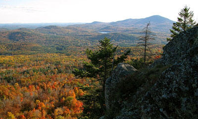
This is a hike up to Mount Kearsarge with outstanding 360-degree views from its bare summit.
Be prepared to hike with this group as our group motto is: We go in a group and we come out as a group. We will hike at a pace of our slowest hiker.
We will be hiking Mt. Kearsarge [2,937 feet] via the Lincoln Trail and Rollins Trail to the summit of Mt. Kearsarge. The total distance covered is 9.2 miles, it should take approximately 6 hours and the elevation gain is 2,100 feet. On a clear day, skyscrapers from Boston 80 miles away are visible from the firetower on the summit.
From the parking area we follow the meandering Link Trail around neat looking boulders to hook up with the Lincoln Trail [part of the Sunapee-Ragged-Kearsarge Greenway Trail]. We'll be having lunch on Baker's Ledge with views towards Sunapee. Once we reach the Rollins State Park upper lot [currently closed] we'll climb to the summit using the Rollins Trail. The summit is large, open and rocky ~ and greatly exposed to the elements.
Mountain weather is subject to rapid changes and extreme conditions. We will assess travel and weather conditions during our hike and make changes to our planned trip as necessary.
Being prepared, traveling with the appropriate gear and knowing how to use it is your personal responsibility. Test and adjust your gear prior to this trip.
Snowshoes and crampons/micro spikes are a must!!
NO COTTON CLOTHING ~ Cotton [the death cloth] has no place in the mountains.
After the hike we can drive into Concord, NH for some apres hiking eating/drinking. Bring a change of clothes to change into after the hike.
Event Coordinators: Mike Boisvert and Jon Normand
Carpooling: Contact other members to carpool, share the conversation and travel expenses. Contact us if you want to carpool with us from Exit 9-S in Manchester at the Burger King parking lot.
Directions
- From I-89 take exit 10 [sign says "To 114" and there's also a brown sign that says "Winslow State Park"].
- At the bottom of the ramp, head east [right if you were heading north].
- Very shortly you come to a T-stop.
- Go right onto North Road and follow that for 0.4 mile.
- Turn left onto Kearsarge Valley Road and follow that also for 0.4 mile.
- Turn right into a fairly obvious cleared dirt/grass parking area. [This may not be plowed and not so obvious in winter]. If you reach the golf course, you've gone 0.4 mile too far.
- There are no signs at the actual parking area ~ but a trailhead sign is visible just inside the woods from the parking area. It's at about the center of the parking area. If we get there early enough you can look for a blue FJ Cruiser which we'll be driving.
About this event
This is a hike up to Mount Kearsarge with outstanding 360-degree views from its bare summit.
Be prepared to hike with this group as our group motto is: We go in a group and we come out as a group. We will hike at a pace of our slowest hiker.
We will be hiking Mt. Kearsarge [2,937 feet] via the Lincoln Trail and Rollins Trail to the summit of Mt. Kearsarge. The total distance covered is 9.2 miles, it should take approximately 6 hours and the elevation gain is 2,100 feet. On a clear day, skyscrapers from Boston 80 miles away are visible from the firetower on the summit.
From the parking area we follow the meandering Link Trail around neat looking boulders to hook up with the Lincoln Trail [part of the Sunapee-Ragged-Kearsarge Greenway Trail]. We'll be having lunch on Baker's Ledge with views towards Sunapee. Once we reach the Rollins State Park upper lot [currently closed] we'll climb to the summit using the Rollins Trail. The summit is large, open and rocky ~ and greatly exposed to the elements.
Mountain weather is subject to rapid changes and extreme conditions. We will assess travel and weather conditions during our hike and make changes to our planned trip as necessary.
Being prepared, traveling with the appropriate gear and knowing how to use it is your personal responsibility. Test and adjust your gear prior to this trip.
Snowshoes and crampons/micro spikes are a must!!
NO COTTON CLOTHING ~ Cotton [the death cloth] has no place in the mountains.
After the hike we can drive into Concord, NH for some apres hiking eating/drinking. Bring a change of clothes to change into after the hike.
Event Coordinators: Mike Boisvert and Jon Normand
Carpooling: Contact other members to carpool, share the conversation and travel expenses. Contact us if you want to carpool with us from Exit 9-S in Manchester at the Burger King parking lot.
Directions to the trailhead
Get directions- From I-89 take exit 10 [sign says "To 114" and there's also a brown sign that says "Winslow State Park"].
- At the bottom of the ramp, head east [right if you were heading north].
- Very shortly you come to a T-stop.
- Go right onto North Road and follow that for 0.4 mile.
- Turn left onto Kearsarge Valley Road and follow that also for 0.4 mile.
- Turn right into a fairly obvious cleared dirt/grass parking area. [This may not be plowed and not so obvious in winter]. If you reach the golf course, you've gone 0.4 mile too far.
- There are no signs at the actual parking area ~ but a trailhead sign is visible just inside the woods from the parking area. It's at about the center of the parking area. If we get there early enough you can look for a blue FJ Cruiser which we'll be driving.
Who's going (4)
 SUSTAINING
 GUEST MEMBER
 SUSTAINING
 GUEST MEMBER
Questions about this event?
Reach out to the host, Gandalf, for route details, carpooling, or what to bring.
Email the hostYou can also ask in the event discussion below.
Event discussion
No comments yet.
Log in to join the conversation.