
GetWinter Hike#5: Mt. Moosilauke
<p>Join our GetWinter Hikes designed to get you into winter hiking. This is it! The 4,000 footer you've been waiting for.</p>
GetWinter Hike#5: Mt. Moosilauke
<p>Join our GetWinter Hikes designed to get you into winter hiking. This is it! The 4,000 footer you've been waiting for.</p>
Details
Join our GetWinter Hikes designed to get you into winter hiking. This is it! The 4,000 footer you've been waiting for.
Be prepared to hike with this group as our group motto is: We go in a group and we come out as a group. We will hike at a pace of our slowest hiker.
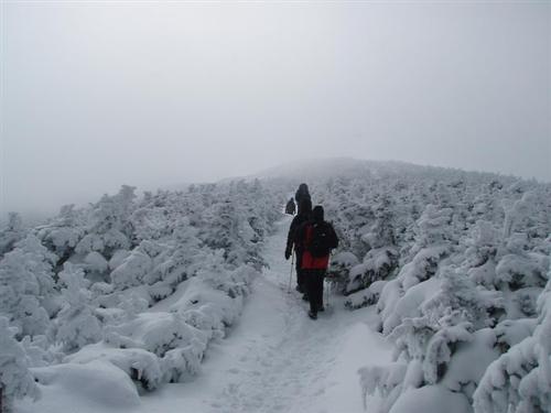
We will be hiking Mt. Moosilauke [4,802 feet] via the Glencliff Trail and Moosilauke Carriage Road to the summit of Mt. Moosilauke. The total distance covered is 7.8 miles, it should take approximately 7 hours and the elevation gain is 3,300 feet. Moosilauke has long been renowned for the breadth and variety of its views, taking in large portions of the White Mountains, central New Hampshire, the Connecticut River Valley and Vermont.
From the parking area we follow an old farm road past a gate. There is only one steep section and the footing is generally good. We reach the ridge and the Moosilauke Carriage Rd. in a sag just north of Moosilauke's South Peak. It is part of the AT. The upper part is above treeline and greatly exposed to the elements, so it can be dangerous in bad weather.
Mountain weather is subject to rapid changes and extreme conditions. We will assess travel and weather conditions during our hike and make changes to our planned trip as necessary.
Being prepared, traveling with the appropriate gear and knowing how to use it is your personal responsibility. Test and adjust your gear prior to this trip.
Snowshoes and crampons/micro spikes are a must!! We highly recommend having goggles, something to cover your neck [scarf, neck gaiter, balaclava] and face [face mask] to protect yourself from frostbite in the event we encounter strong, sub-zero wind chills.
NO COTTON CLOTHING ~ Cotton [the death cloth'] has no place in the mountains.
After the hike we can hang out by the fireplace at my house in Waterville Valley for pizza/beer (sharing costs). Your welcome to bring a change of clothing and take a shower.
Event Coordinators: Mike Boisvert and Jon Normand
Carpooling: Contact other members to carpool, share the conversation and travel expenses. Contact us if you want to carpool with us from Exit 26.
Lodging Option: I have 8 bunks available with linen for Saturday night at my house in Waterville Valley for $20 each night. You can use the kitchen facilities and store beverages/food in the fridge. I serve coffee in the morning and a continental breakfast. Contact me to RSVP. SPACE IS LIMITED TO EIGHT GUYS.
Directions
From I-93 take the Tenney Mountain Highway Exit 26 [Plymouth, NH] and follow NH 25 to the tiny village of Glencliff, between Warren and Haverhill. Turn north onto High St. [formerly Sanatorium Rd.] and drive 1.2 miles to the parking area for Glencliff Trail on right in area of fields and pastures just below Glencliff Home for the Elderly.
About this event
Join our GetWinter Hikes designed to get you into winter hiking. This is it! The 4,000 footer you've been waiting for.
Be prepared to hike with this group as our group motto is: We go in a group and we come out as a group. We will hike at a pace of our slowest hiker.
We will be hiking Mt. Moosilauke [4,802 feet] via the Glencliff Trail and Moosilauke Carriage Road to the summit of Mt. Moosilauke. The total distance covered is 7.8 miles, it should take approximately 7 hours and the elevation gain is 3,300 feet. Moosilauke has long been renowned for the breadth and variety of its views, taking in large portions of the White Mountains, central New Hampshire, the Connecticut River Valley and Vermont.
From the parking area we follow an old farm road past a gate. There is only one steep section and the footing is generally good. We reach the ridge and the Moosilauke Carriage Rd. in a sag just north of Moosilauke's South Peak. It is part of the AT. The upper part is above treeline and greatly exposed to the elements, so it can be dangerous in bad weather.
Mountain weather is subject to rapid changes and extreme conditions. We will assess travel and weather conditions during our hike and make changes to our planned trip as necessary.
Being prepared, traveling with the appropriate gear and knowing how to use it is your personal responsibility. Test and adjust your gear prior to this trip.
Snowshoes and crampons/micro spikes are a must!! We highly recommend having goggles, something to cover your neck [scarf, neck gaiter, balaclava] and face [face mask] to protect yourself from frostbite in the event we encounter strong, sub-zero wind chills.
NO COTTON CLOTHING ~ Cotton [the death cloth'] has no place in the mountains.
After the hike we can hang out by the fireplace at my house in Waterville Valley for pizza/beer (sharing costs). Your welcome to bring a change of clothing and take a shower.
Event Coordinators: Mike Boisvert and Jon Normand
Carpooling: Contact other members to carpool, share the conversation and travel expenses. Contact us if you want to carpool with us from Exit 26.
Lodging Option: I have 8 bunks available with linen for Saturday night at my house in Waterville Valley for $20 each night. You can use the kitchen facilities and store beverages/food in the fridge. I serve coffee in the morning and a continental breakfast. Contact me to RSVP. SPACE IS LIMITED TO EIGHT GUYS.
Directions to the trailhead
Get directionsFrom I-93 take the Tenney Mountain Highway Exit 26 [Plymouth, NH] and follow NH 25 to the tiny village of Glencliff, between Warren and Haverhill. Turn north onto High St. [formerly Sanatorium Rd.] and drive 1.2 miles to the parking area for Glencliff Trail on right in area of fields and pastures just below Glencliff Home for the Elderly.
Who's going (3)
Questions about this event?
Reach out to the host, Gandalf, for route details, carpooling, or what to bring.
Email the hostYou can also ask in the event discussion below.
Event discussion
No comments yet.
Log in to join the conversation.