
Mount Mansfield via Sunset Ridge Hike
<p>Challenging 6.6 mile roundtrip hike up Vermont's highest peak!</p>
Mount Mansfield via Sunset Ridge Hike
<p>Challenging 6.6 mile roundtrip hike up Vermont's highest peak!</p>
Details
We'll meet at the trailhead for the Mt. Mansfield trails at the eastern end of Underhill State Park (there may be a $3 pp fee to enter this state park). Contact hike organizer for details about carpooling from Burlington or getting to Underhill S P. yourself, which is about 17 miles east of Burlington or 22 miles northwest of Montpelier.
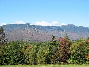
Once on the trail, we'll follow the CCC road up about a mile until the true beginning of the Sunset Ridge Trail. Then we'll follow the SR Trail the rest of the way up to "The Chin," or the summit of Mt. Mansfield. From the summit, if fair weather prevails, we should have fine views of New York, Lake Champlain, and the Green Mountains to the South. After lunch on the summit, we'll head back down the way we came. Total distance is about 6.6 miles.
Check www.weather.gov for Underhill Center, VT or Jericho, VT beforehand but I recommend bringing good boots, plenty of water, lunch, and whatever snacks you want.
Directions
About this event
We'll meet at the trailhead for the Mt. Mansfield trails at the eastern end of Underhill State Park (there may be a $3 pp fee to enter this state park). Contact hike organizer for details about carpooling from Burlington or getting to Underhill S P. yourself, which is about 17 miles east of Burlington or 22 miles northwest of Montpelier.
Once on the trail, we'll follow the CCC road up about a mile until the true beginning of the Sunset Ridge Trail. Then we'll follow the SR Trail the rest of the way up to "The Chin," or the summit of Mt. Mansfield. From the summit, if fair weather prevails, we should have fine views of New York, Lake Champlain, and the Green Mountains to the South. After lunch on the summit, we'll head back down the way we came. Total distance is about 6.6 miles.
Check www.weather.gov for Underhill Center, VT or Jericho, VT beforehand but I recommend bringing good boots, plenty of water, lunch, and whatever snacks you want.
Directions to the trailhead
Get directionsWho's going (0)
No one is on the roster for this event.
Questions about this event?
Questions for the host, vahikerguy, about route details, carpooling, or what to bring? Ask in the event discussion below.
Event discussion
No comments yet.
Log in to join the conversation.